Xianju elevation
Xianju (Zhejiang), China elevation is 60 meters and Xianju elevation in feet is 197 ft above sea level [src 1]. Xianju is a populated place (feature code) with elevation that is 498 meters (1634 ft) smaller than average city elevation in China.
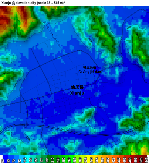
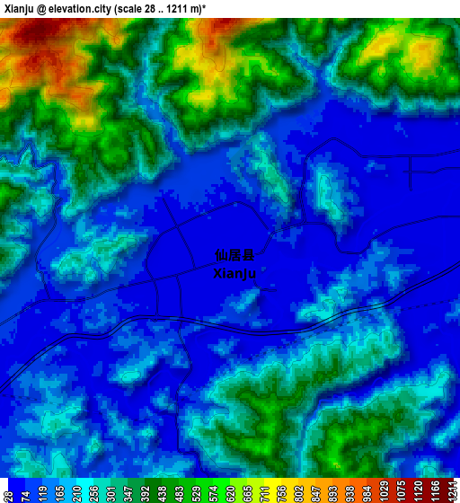
Below is the Elevation map of Xianju, which displays elevation range with different colors. Scale of the first map is from 33 to 545 m (108 to 1788 ft) with average elevation of 106.2 meters (=348 ft) [note 1]
These maps also provides idea of topography and contour of this city, they are displayed at different zoom levels. More info about maps, scale and edge coordinates you can find below images.
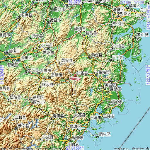
| \ | Map #1 | Map #2 | Topo.Map |
| Scale [m] | 33..545 m | 28..1211 m | × |
| Scale [ft] | 108..1788 ft | 92..3973 ft | × |
| Average | 106.2 m = 348 ft | 237.8 m = 780 ft | × |
| Width | 8.56 km = 5.3 mi | 17.12 km = 10.6 mi | 273.9 km = 170.2 mi |
| Height | 8.56 km = 5.3 mi | 17.12 km = 10.6 mi | 273.9 km = 170.2 mi |
| ↑Max Latitude | 28.893182° | 28.93165° | 30.079° |
| Latitude at center | 28.8547° | 28.8547° | 28.8547° |
| ↓Min Latitude | 28.816204° | 28.777693° | 27.61581° |
| ← Min Longitude | 120.687735° | 120.643789° | 119.32543° |
| Longitude center | 120.73168° | 120.73168° | 120.73168° |
| →Max Longitude | 120.775625° | 120.819571° | 122.13793° |
Nearby cities:
Cities around Xianju sort by population:
• Guli elevation 121 m
68.1 km,  272°
272°
• Linhai 13 m
40.2 km,  89°
89°
• Huangyan 10 m
56.8 km,  113°
113°
• Dongyang 97 m
67.3 km,  313°
313°
• Lubei 11 m
69 km,  115°
115°
• Wuyun 181 m
68.5 km,  250°
250°
• Dongcheng 87 m
67.5 km, 273°
• Dongcheng 9 m
57.4 km, 113°
• Tiantai Chengguanzhen 59 m
42.7 km,  42°
42°
• Gucheng 14 m
37.4 km, 91°
• Pan’an 254 m
36.2 km, 307°
• Fuying 66 m
1.5 km, 306°
Multilingual:
 En español:
Xianju elevación 60 m.
 En France:
Xianju élévation 60 m.


Sources and notes:
- [note 1] Map square and city borders are not equal. Map elevation data is calculated only from area inside that square.
- [src 1] Elevation data from geonames database provided with same terms of usage.
- [src 2] The elevation map of Xianju is generated using elevation data from NASA's 3 arcsec (90m) resolution SRTM data.
- [src 3] Base (background) map © OpenStreetMap contributors tiles are generated by Geofabrik and OpenTopoMap.
Copyright & License:
This Xianju Elevation Map is licensed under CC BY-SA. You may reuse any part from this page, if you give a proper credit by linking to this URL:
 More info on terms of use page.