Zijin elevation
Zijin (Henan), China elevation is 215 meters and Zijin elevation in feet is 705 ft above sea level [src 1]. Zijin is a seat of a third-order administrative division (feature code) with elevation that is 343 meters (1125 ft) smaller than average city elevation in China.
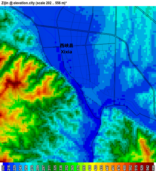
Below is the Elevation map of Zijin, which displays elevation range with different colors. Scale of the first map is from 202 to 556 m (663 to 1824 ft) with average elevation of 281.4 meters (=923 ft) [note 1]
These maps also provides idea of topography and contour of this city, they are displayed at different zoom levels. More info about maps, scale and edge coordinates you can find below images.
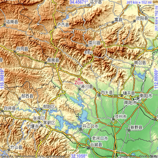
| \ | Map #1 | Topo.Map |
| Scale [m] | 202..556 m | × |
| Scale [ft] | 663..1824 ft | × |
| Average | 281.4 m = 923 ft | × |
| Width | 8.17 km = 5.1 mi | 261.4 km = 162.4 mi |
| Height | 8.17 km = 5.1 mi | 261.4 km = 162.4 mi |
| ↑Max Latitude | 33.325897° | 34.45671° |
| Latitude at center | 33.28917° | 33.28917° |
| ↓Min Latitude | 33.252428° | 32.1058° |
| ← Min Longitude | 111.430495° | 110.06819° |
| Longitude center | 111.47444° | 111.47444° |
| →Max Longitude | 111.518385° | 112.88069° |
Nearby cities:
Cities around Zijin sort by population:
• Shiyan elevation 247 m
96.5 km,  222°
222°
• Laohekou 93 m
102.1 km,  169°
169°
• Nanyang 131 m
103.8 km,  108°
108°
• Danjiangkou 108 m
83.1 km,  177°
177°
• Huazhou 119 m
88.1 km,  139°
139°
• Yunxixian Chengguanzhen 222 m
103.6 km,  250°
250°
• Lushi Chengguanzhen 584 m
93.8 km,  334°
334°
• Nanzhao Chengguanzhen 206 m
91.3 km,  75°
75°
• Yunxian Chengguanzhen 203 m
80.3 km,  230°
230°
• Zhenping Chengguanzhen 189 m
76.1 km, 111°
• Luanchuan Chengguanzhen 742 m
56.2 km,  13°
13°
• Neixiang Chengguanzhen 174 m
43.7 km,  128°
128°
Multilingual:
 En español:
Zijin elevación 215 m.
 En France:
Zijin élévation 215 m.


Sources and notes:
- [note 1] Map square and city borders are not equal. Map elevation data is calculated only from area inside that square.
- [src 1] Elevation data from geonames database provided with same terms of usage.
- [src 2] The elevation map of Zijin is generated using elevation data from NASA's 3 arcsec (90m) resolution SRTM data.
- [src 3] Base (background) map © OpenStreetMap contributors tiles are generated by Geofabrik and OpenTopoMap.
Copyright & License:
This Zijin Elevation Map is licensed under CC BY-SA. You may reuse any part from this page, if you give a proper credit by linking to this URL:
 More info on terms of use page.