Yuncheng elevation
Yuncheng (Shanxi), China elevation is 361 meters and Yuncheng elevation in feet is 1184 ft above sea level [src 1]. Yuncheng is a populated place (feature code) with elevation that is 197 meters (646 ft) smaller than average city elevation in China.
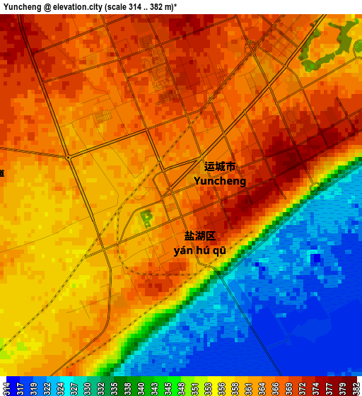
Below is the Elevation map of Yuncheng, which displays elevation range with different colors. Scale of the first map is from 314 to 382 m (1030 to 1253 ft) with average elevation of 354.9 meters (=1164 ft) [note 1]
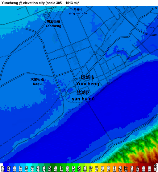
These maps also provides idea of topography and contour of this city, they are displayed at different zoom levels. More info about maps, scale and edge coordinates you can find below images.
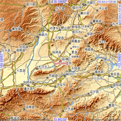
| \ | Map #1 | Map #2 | Topo.Map |
| Scale [m] | 314..382 m | 305..1013 m | × |
| Scale [ft] | 1030..1253 ft | 1001..3323 ft | × |
| Average | 354.9 m = 1164 ft | 370 m = 1214 ft | × |
| Width | 8 km = 5 mi | 16.01 km = 9.9 mi | 256.1 km = 159.1 mi |
| Height | 8 km = 5 mi | 16.01 km = 9.9 mi | 256.1 km = 159.1 mi |
| ↑Max Latitude | 35.05904° | 35.095004° | 36.16652° |
| Latitude at center | 35.02306° | 35.02306° | 35.02306° |
| ↓Min Latitude | 34.987064° | 34.951053° | 33.86338° |
| ← Min Longitude | 110.948835° | 110.904889° | 109.58653° |
| Longitude center | 110.99278° | 110.99278° | 110.99278° |
| →Max Longitude | 111.036725° | 111.080671° | 112.39903° |
Nearby cities:
Cities around Yuncheng sort by population:
• Hancheng elevation 383 m
70.6 km,  313°
313°
• Longxing 401 m
68.7 km,  17°
17°
• Xincheng 555 m
68.4 km,  63°
63°
• Jifeng 402 m
65.7 km,  357°
357°
• Lingbao Chengguanzhen 407 m
57.2 km,  191°
191°
• Xiedian 578 m
47.9 km,  339°
339°
• Guwei 565 m
46.3 km,  221°
221°
• Tongcheng 470 m
42.1 km,  28°
28°
• Daying 356 m
35 km,  163°
163°
• Yishi 482 m
27.4 km, 305°
• Shengrenjian 387 m
26.9 km,  137°
137°
• Yaofeng 410 m
23.7 km, 57°
Multilingual:
 En español:
Yuncheng elevación 361 m.
 En France:
Yuncheng élévation 361 m.
 Auf Deutsch:
Yuncheng höhe über dem Meeresspiegel ist 361 m.

Sources and notes:
- [note 1] Map square and city borders are not equal. Map elevation data is calculated only from area inside that square.
- [src 1] Elevation data from geonames database provided with same terms of usage.
- [src 2] The elevation map of Yuncheng is generated using elevation data from NASA's 3 arcsec (90m) resolution SRTM data.
- [src 3] Base (background) map © OpenStreetMap contributors tiles are generated by Geofabrik and OpenTopoMap.
Copyright & License:
This Yuncheng Elevation Map is licensed under CC BY-SA. You may reuse any part from this page, if you give a proper credit by linking to this URL:
 More info on terms of use page.