Zunyi elevation
Zunyi (Guizhou), China elevation is 867 meters and Zunyi elevation in feet is 2844 ft above sea level [src 1]. Zunyi is a populated place (feature code) with elevation that is 309 meters (1014 ft) bigger than average city elevation in China.
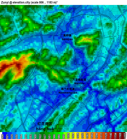
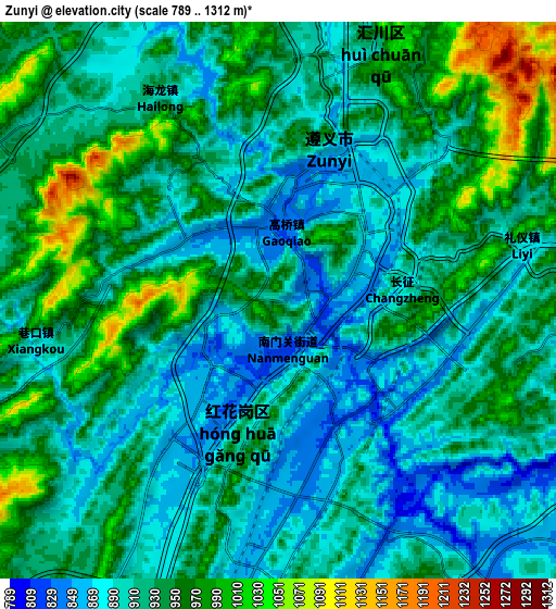
Below is the Elevation map of Zunyi, which displays elevation range with different colors. Scale of the first map is from 806 to 1183 m (2644 to 3881 ft) with average elevation of 884.2 meters (=2901 ft) [note 1]
These maps also provides idea of topography and contour of this city, they are displayed at different zoom levels. More info about maps, scale and edge coordinates you can find below images.
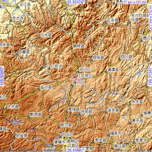
| \ | Map #1 | Map #2 | Topo.Map |
| Scale [m] | 806..1183 m | 789..1312 m | × |
| Scale [ft] | 2644..3881 ft | 2589..4304 ft | × |
| Average | 884.2 m = 2901 ft | 925.2 m = 3035 ft | × |
| Width | 8.65 km = 5.4 mi | 17.31 km = 10.8 mi | 276.9 km = 172.1 mi |
| Height | 8.65 km = 5.4 mi | 17.31 km = 10.8 mi | 276.9 km = 172.1 mi |
| ↑Max Latitude | 27.725577° | 27.76447° | 28.92474° |
| Latitude at center | 27.68667° | 27.68667° | 27.68667° |
| ↓Min Latitude | 27.647749° | 27.608815° | 26.43441° |
| ← Min Longitude | 106.863275° | 106.819329° | 105.50097° |
| Longitude center | 106.90722° | 106.90722° | 106.90722° |
| →Max Longitude | 106.951165° | 106.995111° | 108.31347° |
Nearby cities:
Cities around Zunyi sort by population:
• Loushanguan elevation 935 m
50.7 km,  350°
350°
• Wenshui 1039 m
92.8 km,  336°
336°
• Songkan 425 m
96.1 km,  357°
357°
• Chumi 980 m
61.3 km, 353°
• Taiping 327 m
99.2 km,  300°
300°
• Xinzhan 528 m
78.2 km, 356°
• Sanchahe 1157 m
101.4 km,  332°
332°
• Liangcunchang 1070 m
93 km, 329°
• Huaqiu 1050 m
56.4 km, 327°
• Sangmu 1179 m
85.9 km,  313°
313°
• Donghuang 1208 m
98.9 km,  316°
316°
• Renhuai 848 m
51.2 km,  283°
283°
Multilingual:
 En español:
Zunyi elevación 867 m.
 En France:
Zunyi élévation 867 m.


Sources and notes:
- [note 1] Map square and city borders are not equal. Map elevation data is calculated only from area inside that square.
- [src 1] Elevation data from geonames database provided with same terms of usage.
- [src 2] The elevation map of Zunyi is generated using elevation data from NASA's 3 arcsec (90m) resolution SRTM data.
- [src 3] Base (background) map © OpenStreetMap contributors tiles are generated by Geofabrik and OpenTopoMap.
Copyright & License:
This Zunyi Elevation Map is licensed under CC BY-SA. You may reuse any part from this page, if you give a proper credit by linking to this URL:
 More info on terms of use page.