Bertoua elevation
Bertoua (East), Cameroon elevation is 665 meters and Bertoua elevation in feet is 2182 ft above sea level [src 1]. Bertoua is a seat of a first-order administrative division (feature code) with elevation that is 10 meters (33 ft) smaller than average city elevation in Cameroon.
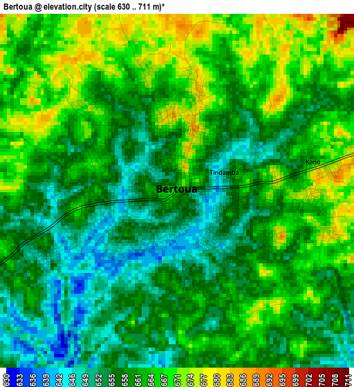
Below is the Elevation map of Bertoua, which displays elevation range with different colors. Scale of the first map is from 630 to 711 m (2067 to 2333 ft) with average elevation of 660.7 meters (=2168 ft) [note 1]
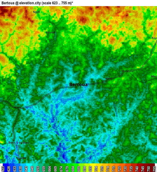
These maps also provides idea of topography and contour of this city, they are displayed at different zoom levels. More info about maps, scale and edge coordinates you can find below images.
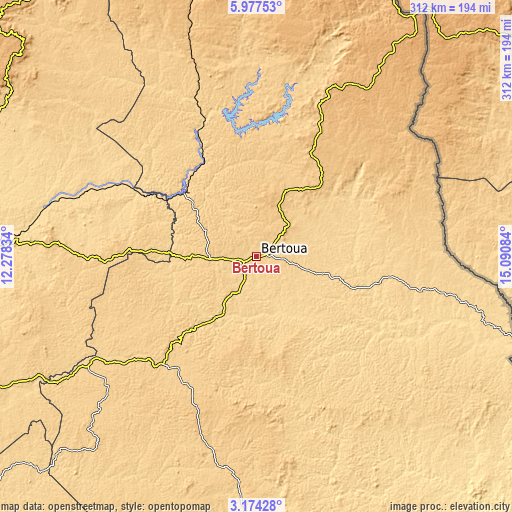
| \ | Map #1 | Map #2 | Topo.Map |
| Scale [m] | 630..711 m | 623..755 m | × |
| Scale [ft] | 2067..2333 ft | 2044..2477 ft | × |
| Average | 660.7 m = 2168 ft | 671.6 m = 2203 ft | × |
| Width | 9.74 km = 6.1 mi | 19.48 km = 12.1 mi | 311.7 km = 193.7 mi |
| Height | 9.74 km = 6.1 mi | 19.48 km = 12.1 mi | 311.7 km = 193.7 mi |
| ↑Max Latitude | 4.621084° | 4.664885° | 5.97753° |
| Latitude at center | 4.57728° | 4.57728° | 4.57728° |
| ↓Min Latitude | 4.533474° | 4.489664° | 3.17428° |
| ← Min Longitude | 13.640645° | 13.596699° | 12.27834° |
| Longitude center | 13.68459° | 13.68459° | 13.68459° |
| →Max Longitude | 13.728535° | 13.772481° | 15.09084° |
Nearby cities:
Cities around Bertoua sort by population:
• Garoua Boulaï elevation 1034 m
174 km,  33°
33°
• Batouri 631 m
77.3 km,  101°
101°
• Nanga Eboko 615 m
146.5 km,  274°
274°
• Bélabo 614 m
58.2 km,  312°
312°
• Akonolinga 643 m
182.8 km,  240°
240°
• Abong Mbang 694 m
86.3 km,  220°
220°
• Bétaré Oya 768 m
122 km,  21°
21°
• Dimako 649 m
25.2 km,  211°
211°
• Doumé 630 m
46.2 km, 214°
• Ndelele 605 m
149.9 km,  113°
113°
• Minta 667 m
98 km, 270°
• Mbang 683 m
38.9 km, 270°
Multilingual:
 En español:
Bertoua elevación 665 m.
 En France:
Bertoua élévation 665 m.


Sources and notes:
- [note 1] Map square and city borders are not equal. Map elevation data is calculated only from area inside that square.
- [src 1] Elevation data from geonames database provided with same terms of usage.
- [src 2] The elevation map of Bertoua is generated using elevation data from NASA's 3 arcsec (90m) resolution SRTM data.
- [src 3] Base (background) map © OpenStreetMap contributors tiles are generated by Geofabrik and OpenTopoMap.
Copyright & License:
This Bertoua Elevation Map is licensed under CC BY-SA. You may reuse any part from this page, if you give a proper credit by linking to this URL:
 More info on terms of use page.