Minta elevation
Minta (Centre), Cameroon elevation is 667 meters and Minta elevation in feet is 2188 ft above sea level [src 1]. Minta is a populated place (feature code) with elevation that is 8 meters (26 ft) smaller than average city elevation in Cameroon.
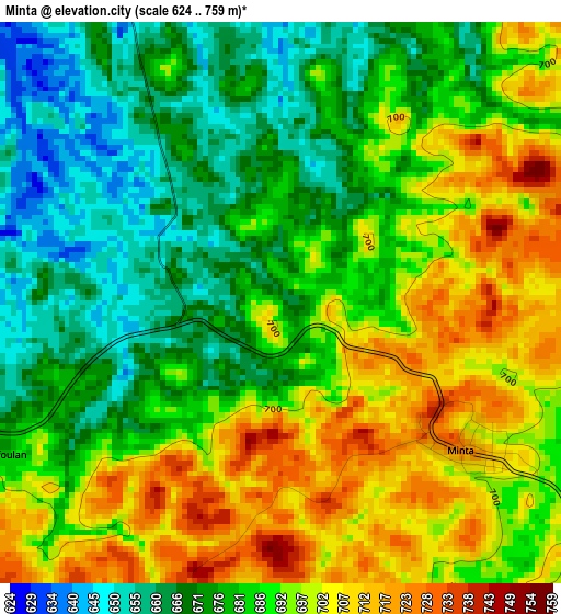
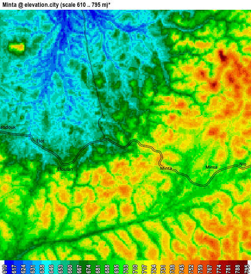
Below is the Elevation map of Minta, which displays elevation range with different colors. Scale of the first map is from 624 to 759 m (2047 to 2490 ft) with average elevation of 686.7 meters (=2253 ft) [note 1]
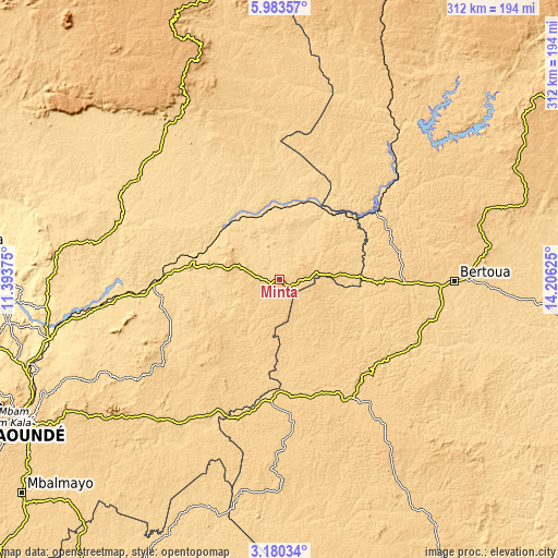
These maps also provides idea of topography and contour of this city, they are displayed at different zoom levels. More info about maps, scale and edge coordinates you can find below images.
| \ | Map #1 | Map #2 | Topo.Map |
| Scale [m] | 624..759 m | 610..795 m | × |
| Scale [ft] | 2047..2490 ft | 2001..2608 ft | × |
| Average | 686.7 m = 2253 ft | 688 m = 2257 ft | × |
| Width | 9.74 km = 6.1 mi | 19.48 km = 12.1 mi | 311.7 km = 193.7 mi |
| Height | 9.74 km = 6.1 mi | 19.48 km = 12.1 mi | 311.7 km = 193.7 mi |
| ↑Max Latitude | 4.627133° | 4.670934° | 5.98357° |
| Latitude at center | 4.58333° | 4.58333° | 4.58333° |
| ↓Min Latitude | 4.539524° | 4.495715° | 3.18034° |
| ← Min Longitude | 12.756055° | 12.712109° | 11.39375° |
| Longitude center | 12.8° | 12.8° | 12.8° |
| →Max Longitude | 12.843945° | 12.887891° | 14.20625° |
Nearby cities:
Cities around Minta sort by population:
• Bertoua elevation 665 m
98 km,  90°
90°
• Nkoteng 583 m
85.3 km,  265°
265°
• Nanga Eboko 615 m
49.3 km,  283°
283°
• Mbandjok 548 m
100.9 km,  261°
261°
• Bélabo 614 m
67.7 km,  54°
54°
• Akonolinga 643 m
109.4 km,  213°
213°
• Abong Mbang 694 m
79.1 km,  147°
147°
• Dimako 649 m
87.8 km,  104°
104°
• Doumé 630 m
81.9 km,  118°
118°
• Yoko 992 m
118.4 km,  333°
333°
• Essé 640 m
113.3 km,  241°
241°
• Mbang 683 m
59.1 km, 90°
Multilingual:
 En español:
Minta elevación 667 m.
 En France:
Minta élévation 667 m.


Sources and notes:
- [note 1] Map square and city borders are not equal. Map elevation data is calculated only from area inside that square.
- [src 1] Elevation data from geonames database provided with same terms of usage.
- [src 2] The elevation map of Minta is generated using elevation data from NASA's 3 arcsec (90m) resolution SRTM data.
- [src 3] Base (background) map © OpenStreetMap contributors tiles are generated by Geofabrik and OpenTopoMap.
Copyright & License:
This Minta Elevation Map is licensed under CC BY-SA. You may reuse any part from this page, if you give a proper credit by linking to this URL:
 More info on terms of use page.