Nguti elevation
Nguti (South-West), Cameroon elevation is 228 meters and Nguti elevation in feet is 748 ft above sea level [src 1]. Nguti is a populated place (feature code) with elevation that is 447 meters (1467 ft) smaller than average city elevation in Cameroon.
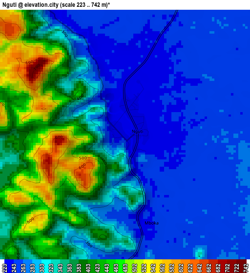
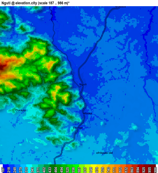
Below is the Elevation map of Nguti, which displays elevation range with different colors. Scale of the first map is from 223 to 742 m (732 to 2434 ft) with average elevation of 328 meters (=1076 ft) [note 1]
These maps also provides idea of topography and contour of this city, they are displayed at different zoom levels. More info about maps, scale and edge coordinates you can find below images.
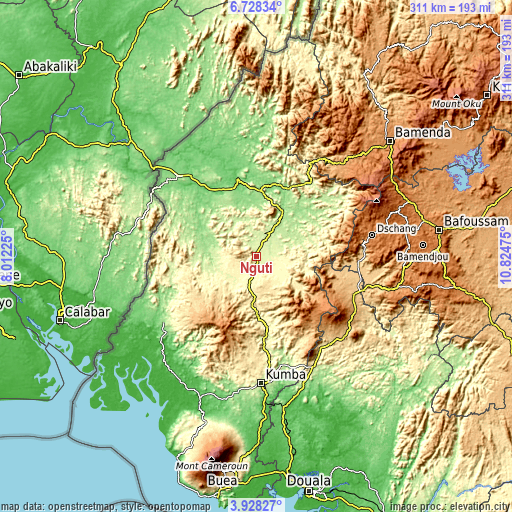
| \ | Map #1 | Map #2 | Topo.Map |
| Scale [m] | 223..742 m | 187..986 m | × |
| Scale [ft] | 732..2434 ft | 614..3235 ft | × |
| Average | 328 m = 1076 ft | 310.7 m = 1019 ft | × |
| Width | 9.73 km = 6 mi | 19.46 km = 12.1 mi | 311.3 km = 193.4 mi |
| Height | 9.73 km = 6 mi | 19.46 km = 12.1 mi | 311.4 km = 193.5 mi |
| ↑Max Latitude | 5.373654° | 5.417404° | 6.72834° |
| Latitude at center | 5.3299° | 5.3299° | 5.3299° |
| ↓Min Latitude | 5.286143° | 5.242383° | 3.92827° |
| ← Min Longitude | 9.374555° | 9.330609° | 8.01225° |
| Longitude center | 9.4185° | 9.4185° | 9.4185° |
| →Max Longitude | 9.462445° | 9.506391° | 10.82475° |
Nearby cities:
Cities around Nguti sort by population:
• Loum elevation 235 m
76.5 km,  152°
152°
• Kumba 244 m
77.2 km,  177°
177°
• Nkongsamba 844 m
71.3 km,  125°
125°
• Dschang 1345 m
71.4 km,  79°
79°
• Fontem 902 m
53.6 km,  73°
73°
• Manjo 526 m
70.2 km,  140°
140°
• Melong 792 m
64.4 km,  111°
111°
• Penja 148 m
82.1 km,  159°
159°
• Mamfe 93 m
48.3 km,  346°
346°
• Mundemba 111 m
73.9 km,  234°
234°
• Batibo 1090 m
74.2 km,  40°
40°
• Bekondo 382 m
72.8 km,  188°
188°
Multilingual:
 En español:
Nguti elevación 228 m.
 En France:
Nguti élévation 228 m.


Sources and notes:
- [note 1] Map square and city borders are not equal. Map elevation data is calculated only from area inside that square.
- [src 1] Elevation data from geonames database provided with same terms of usage.
- [src 2] The elevation map of Nguti is generated using elevation data from NASA's 3 arcsec (90m) resolution SRTM data.
- [src 3] Base (background) map © OpenStreetMap contributors tiles are generated by Geofabrik and OpenTopoMap.
Copyright & License:
This Nguti Elevation Map is licensed under CC BY-SA. You may reuse any part from this page, if you give a proper credit by linking to this URL:
 More info on terms of use page.