Melong elevation
Melong (Littoral), Cameroon elevation is 792 meters and Melong elevation in feet is 2598 ft above sea level [src 1]. Melong is a populated place (feature code) with elevation that is 117 meters (384 ft) bigger than average city elevation in Cameroon.
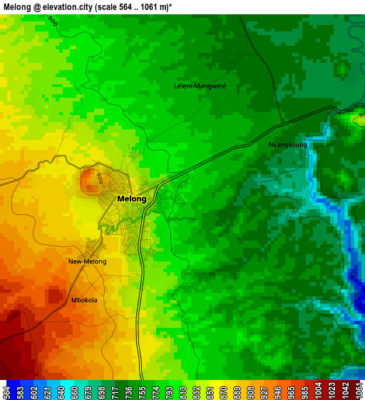
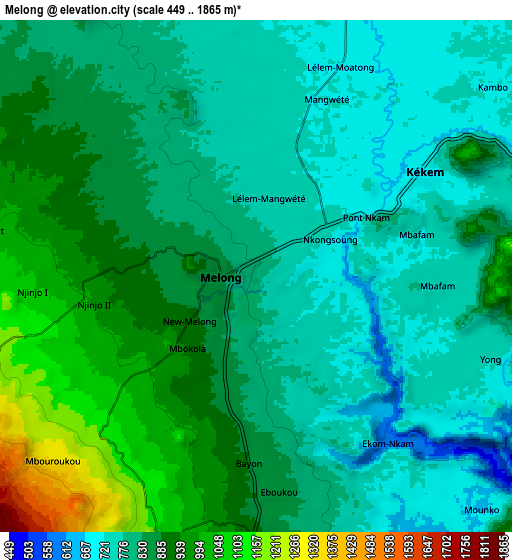
Below is the Elevation map of Melong, which displays elevation range with different colors. Scale of the first map is from 564 to 1061 m (1850 to 3481 ft) with average elevation of 794.9 meters (=2608 ft) [note 1]
These maps also provides idea of topography and contour of this city, they are displayed at different zoom levels. More info about maps, scale and edge coordinates you can find below images.
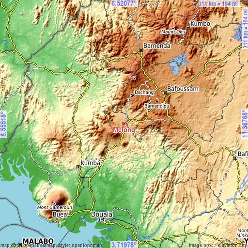
| \ | Map #1 | Map #2 | Topo.Map |
| Scale [m] | 564..1061 m | 449..1865 m | × |
| Scale [ft] | 1850..3481 ft | 1473..6119 ft | × |
| Average | 794.9 m = 2608 ft | 846.8 m = 2778 ft | × |
| Width | 9.73 km = 6 mi | 19.47 km = 12.1 mi | 311.4 km = 193.5 mi |
| Height | 9.73 km = 6 mi | 19.47 km = 12.1 mi | 311.5 km = 193.6 mi |
| ↑Max Latitude | 5.165578° | 5.209344° | 6.52077° |
| Latitude at center | 5.12181° | 5.12181° | 5.12181° |
| ↓Min Latitude | 5.078039° | 5.034264° | 3.71978° |
| ← Min Longitude | 9.917485° | 9.873539° | 8.55518° |
| Longitude center | 9.96143° | 9.96143° | 9.96143° |
| →Max Longitude | 10.005375° | 10.049321° | 11.36768° |
Nearby cities:
Cities around Melong sort by population:
• Loum elevation 235 m
51.4 km,  209°
209°
• Nkongsamba 844 m
18.7 km,  187°
187°
• Dschang 1345 m
37.2 km,  15°
15°
• Bafang 1179 m
24.2 km,  80°
80°
• Fontem 902 m
39.5 km,  347°
347°
• Manjo 526 m
34.7 km, 206°
• Bazou 1206 m
56.5 km,  96°
96°
• Bansoa 1483 m
53.3 km,  47°
47°
• Ngou 1441 m
47.7 km, 79°
• Bandjoun 1529 m
57.4 km,  60°
60°
• Bamendjou 1604 m
50.5 km, 53°
• Bana 1415 m
34.9 km,  85°
85°
Multilingual:
 En español:
Melong elevación 792 m.
 En France:
Melong élévation 792 m.


Sources and notes:
- [note 1] Map square and city borders are not equal. Map elevation data is calculated only from area inside that square.
- [src 1] Elevation data from geonames database provided with same terms of usage.
- [src 2] The elevation map of Melong is generated using elevation data from NASA's 3 arcsec (90m) resolution SRTM data.
- [src 3] Base (background) map © OpenStreetMap contributors tiles are generated by Geofabrik and OpenTopoMap.
Copyright & License:
This Melong Elevation Map is licensed under CC BY-SA. You may reuse any part from this page, if you give a proper credit by linking to this URL:
 More info on terms of use page.