Chaitén elevation
Chaitén (Los Lagos Region, Provincia de Palena), Chile elevation is 17 meters and Chaitén elevation in feet is 56 ft above sea level [src 1]. Chaitén is a populated place (feature code) with elevation that is 258 meters (846 ft) smaller than average city elevation in Chile.
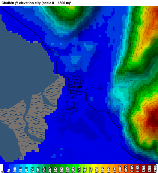
Below is the Elevation map of Chaitén, which displays elevation range with different colors. Scale of the first map is from 0 to 1306 m (0 to 4285 ft) with average elevation of 205.3 meters (=674 ft) [note 1]
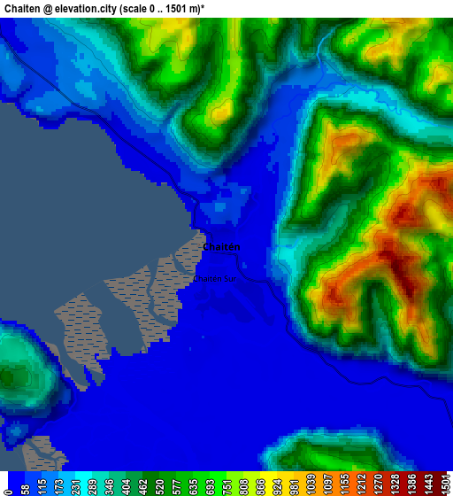
These maps also provides idea of topography and contour of this city, they are displayed at different zoom levels. More info about maps, scale and edge coordinates you can find below images.
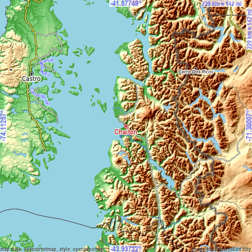
| \ | Map #1 | Map #2 | Topo.Map |
| Scale [m] | 0..1306 m | 0..1501 m | × |
| Scale [ft] | 0..4285 ft | 0..4925 ft | × |
| Average | 205.3 m = 674 ft | 329 m = 1079 ft | × |
| Width | 7.16 km = 4.4 mi | 14.31 km = 8.9 mi | 229 km = 142.3 mi |
| Height | 7.16 km = 4.4 mi | 14.31 km = 8.9 mi | 229 km = 142.3 mi |
| ↑Max Latitude | -42.883768° | -42.851559° | -41.87749° |
| Latitude at center | -42.91596° | -42.91596° | -42.91596° |
| ↓Min Latitude | -42.948135° | -42.980293° | -43.93722° |
| ← Min Longitude | -72.750265° | -72.794211° | -74.11257° |
| Longitude center | -72.70632° | -72.70632° | -72.70632° |
| →Max Longitude | -72.662375° | -72.618429° | -71.30007° |
Nearby cities:
Cities around Chaitén sort by population:
• Puerto Montt elevation 27 m
162 km,  353°
353°
• Castro 81 m
100.2 km,  299°
299°
• Ancud 51 m
147.7 km,  321°
321°
• Puerto Varas 60 m
179 km, 352°
• Quellón 23 m
77.3 km,  253°
253°
• Dalcahue 19 m
97.6 km,  307°
307°
• Chonchi 20 m
93.1 km,  290°
290°
• Calbuco 38 m
131.7 km,  344°
344°
• Futaleufú 351 m
74.4 km,  113°
113°
• Palena 262 m
107 km,  136°
136°
• La Ensenada 58 m
190.5 km,  4°
4°
• La Junta 51 m
120.2 km,  168°
168°
Multilingual:
 En español:
Chaitén elevación 17 m.
 En France:
Chaitén élévation 17 m.


Sources and notes:
- [note 1] Map square and city borders are not equal. Map elevation data is calculated only from area inside that square.
- [src 1] Elevation data from geonames database provided with same terms of usage.
- [src 2] The elevation map of Chaitén is generated using elevation data from NASA's 3 arcsec (90m) resolution SRTM data.
- [src 3] Base (background) map © OpenStreetMap contributors tiles are generated by Geofabrik and OpenTopoMap.
Copyright & License:
This Chaitén Elevation Map is licensed under CC BY-SA. You may reuse any part from this page, if you give a proper credit by linking to this URL:
 More info on terms of use page.