La Ensenada elevation
La Ensenada (Los Lagos Region, Provincia de Llanquihue), Chile elevation is 58 meters and La Ensenada elevation in feet is 190 ft above sea level [src 1]. La Ensenada is a populated place (feature code) with elevation that is 217 meters (712 ft) smaller than average city elevation in Chile.
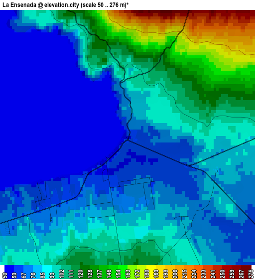
Below is the Elevation map of La Ensenada, which displays elevation range with different colors. Scale of the first map is from 50 to 276 m (164 to 906 ft) with average elevation of 90.8 meters (=298 ft) [note 1]
These maps also provides idea of topography and contour of this city, they are displayed at different zoom levels. More info about maps, scale and edge coordinates you can find below images.

| \ | Map #1 | Topo.Map |
| Scale [m] | 50..276 m | × |
| Scale [ft] | 164..906 ft | × |
| Average | 90.8 m = 298 ft | × |
| Width | 7.35 km = 4.6 mi | 235.3 km = 146.2 mi |
| Height | 7.35 km = 4.6 mi | 235.3 km = 146.2 mi |
| ↑Max Latitude | -41.17439° | -40.14096° |
| Latitude at center | -41.20746° | -41.20746° |
| ↓Min Latitude | -41.240513° | -42.25686° |
| ← Min Longitude | -72.582345° | -73.94465° |
| Longitude center | -72.5384° | -72.5384° |
| →Max Longitude | -72.494455° | -71.13215° |
Nearby cities:
Cities around La Ensenada sort by population:
• Puerto Montt elevation 27 m
44.6 km,  229°
229°
• Osorno 37 m
86.4 km,  324°
324°
• Ancud 51 m
129.4 km,  235°
235°
• La Unión 32 m
111.5 km,  335°
335°
• Puerto Varas 60 m
39.4 km,  251°
251°
• Río Bueno 61 m
103.2 km, 340°
• Purranque 119 m
61.5 km,  302°
302°
• Dalcahue 19 m
159.5 km,  215°
215°
• Calbuco 38 m
79.9 km, 218°
• Puyehue 211 m
61.2 km,  355°
355°
• Corral 5 m
165 km,  332°
332°
• Las Gaviotas 11 m
158.9 km, 339°
Multilingual:
 En español:
La Ensenada elevación 58 m.
 En France:
La Ensenada élévation 58 m.
 Auf Deutsch:
La Ensenada höhe über dem Meeresspiegel ist 58 m.

Sources and notes:
- [note 1] Map square and city borders are not equal. Map elevation data is calculated only from area inside that square.
- [src 1] Elevation data from geonames database provided with same terms of usage.
- [src 2] The elevation map of La Ensenada is generated using elevation data from NASA's 3 arcsec (90m) resolution SRTM data.
- [src 3] Base (background) map © OpenStreetMap contributors tiles are generated by Geofabrik and OpenTopoMap.
Copyright & License:
This La Ensenada Elevation Map is licensed under CC BY-SA. You may reuse any part from this page, if you give a proper credit by linking to this URL:
 More info on terms of use page.