Panguipulli elevation
Panguipulli (Los Ríos Region, Provincia de Valdivia), Chile elevation is 140 meters and Panguipulli elevation in feet is 459 ft above sea level [src 1]. Panguipulli is a populated place (feature code) with elevation that is 135 meters (443 ft) smaller than average city elevation in Chile.
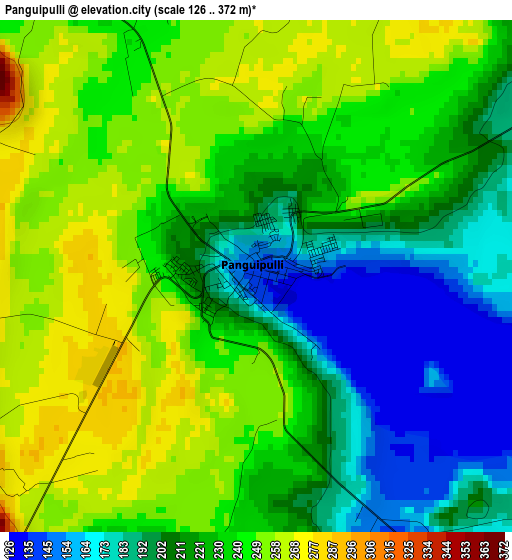
Below is the Elevation map of Panguipulli, which displays elevation range with different colors. Scale of the first map is from 126 to 372 m (413 to 1220 ft) with average elevation of 224.7 meters (=737 ft) [note 1]
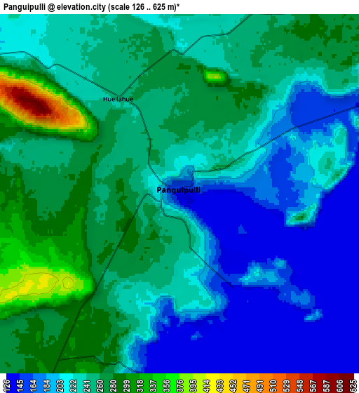
These maps also provides idea of topography and contour of this city, they are displayed at different zoom levels. More info about maps, scale and edge coordinates you can find below images.
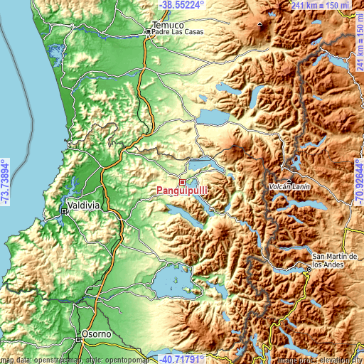
| \ | Map #1 | Map #2 | Topo.Map |
| Scale [m] | 126..372 m | 126..625 m | × |
| Scale [ft] | 413..1220 ft | 413..2051 ft | × |
| Average | 224.7 m = 737 ft | 232.3 m = 762 ft | × |
| Width | 7.53 km = 4.7 mi | 15.05 km = 9.4 mi | 240.8 km = 149.6 mi |
| Height | 7.53 km = 4.7 mi | 15.05 km = 9.4 mi | 240.8 km = 149.6 mi |
| ↑Max Latitude | -39.609703° | -39.575839° | -38.55224° |
| Latitude at center | -39.64355° | -39.64355° | -39.64355° |
| ↓Min Latitude | -39.677381° | -39.711195° | -40.71791° |
| ← Min Longitude | -72.376635° | -72.420581° | -73.73894° |
| Longitude center | -72.33269° | -72.33269° | -72.33269° |
| →Max Longitude | -72.288745° | -72.244799° | -70.92644° |
Nearby cities:
Cities around Panguipulli sort by population:
• Temuco elevation 114 m
103.1 km,  347°
347°
• Valdivia 17 m
80.4 km,  256°
256°
• Villarrica 232 m
40.8 km,  12°
12°
• Las Animas 10 m
77.9 km, 256°
• Pucón 236 m
51.7 km,  38°
38°
• La Unión 32 m
96.4 km,  221°
221°
• Loncoche 114 m
40 km,  320°
320°
• Río Bueno 61 m
93.4 km,  214°
214°
• Pitrufquén 99 m
77.6 km,  340°
340°
• Freire 108 m
80.9 km, 341°
• Corral 5 m
97.7 km,  253°
253°
• Las Gaviotas 11 m
77.2 km, 251°
Multilingual:
 En español:
Panguipulli elevación 140 m.
 En France:
Panguipulli élévation 140 m.
 Auf Deutsch:
Panguipulli höhe über dem Meeresspiegel ist 140 m.

Sources and notes:
- [note 1] Map square and city borders are not equal. Map elevation data is calculated only from area inside that square.
- [src 1] Elevation data from geonames database provided with same terms of usage.
- [src 2] The elevation map of Panguipulli is generated using elevation data from NASA's 3 arcsec (90m) resolution SRTM data.
- [src 3] Base (background) map © OpenStreetMap contributors tiles are generated by Geofabrik and OpenTopoMap.
Copyright & License:
This Panguipulli Elevation Map is licensed under CC BY-SA. You may reuse any part from this page, if you give a proper credit by linking to this URL:
 More info on terms of use page.