San Vicente elevation
San Vicente (O'Higgins Region, Provincia de Cachapoal), Chile elevation is 210 meters and San Vicente elevation in feet is 689 ft above sea level [src 1]. San Vicente is a populated place (feature code) with elevation that is 65 meters (213 ft) smaller than average city elevation in Chile.
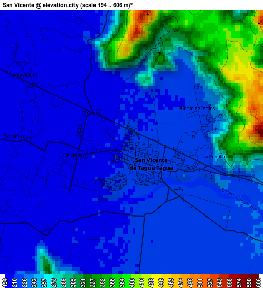
Below is the Elevation map of San Vicente, which displays elevation range with different colors. Scale of the first map is from 194 to 606 m (636 to 1988 ft) with average elevation of 242 meters (=794 ft) [note 1]
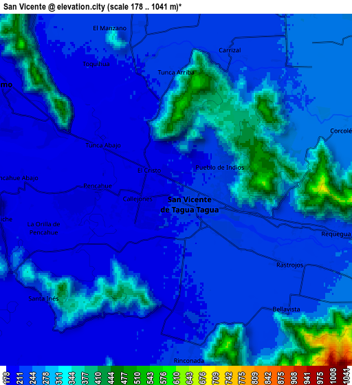
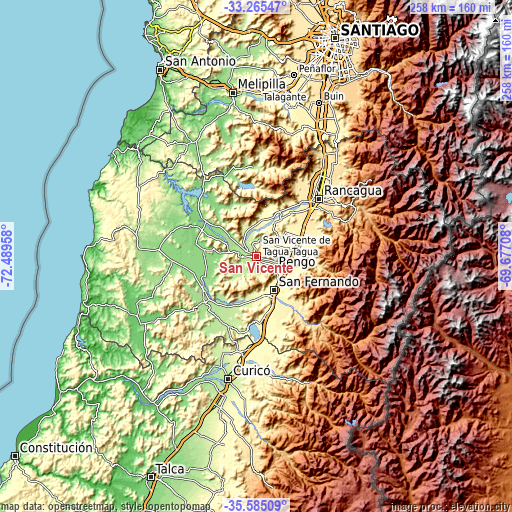
These maps also provides idea of topography and contour of this city, they are displayed at different zoom levels. More info about maps, scale and edge coordinates you can find below images.
| \ | Map #1 | Map #2 | Topo.Map |
| Scale [m] | 194..606 m | 178..1041 m | × |
| Scale [ft] | 636..1988 ft | 584..3415 ft | × |
| Average | 242 m = 794 ft | 257 m = 843 ft | × |
| Width | 8.06 km = 5 mi | 16.12 km = 10 mi | 257.9 km = 160.3 mi |
| Height | 8.06 km = 5 mi | 16.12 km = 10 mi | 257.9 km = 160.3 mi |
| ↑Max Latitude | -34.397077° | -34.360808° | -33.26547° |
| Latitude at center | -34.43333° | -34.43333° | -34.43333° |
| ↓Min Latitude | -34.469568° | -34.505789° | -35.58509° |
| ← Min Longitude | -71.127275° | -71.171221° | -72.48958° |
| Longitude center | -71.08333° | -71.08333° | -71.08333° |
| →Max Longitude | -71.039385° | -70.995439° | -69.67708° |
Nearby cities:
Cities around San Vicente sort by population:
• Rancagua elevation 506 m
42.7 km,  46°
46°
• Curicó 217 m
62.7 km,  193°
193°
• Rengo 326 m
20.9 km,  81°
81°
• Santa Cruz 174 m
34.5 km,  228°
228°
• Paine 407 m
76.3 km,  24°
24°
• San Vicente de Tagua Tagua 214 m
0.8 km,  137°
137°
• Molina 253 m
77.9 km, 193°
• Machalí 568 m
48.8 km, 54°
• Graneros 483 m
52.1 km,  38°
38°
• Chimbarongo 309 m
31.3 km,  173°
173°
• Rauco 195 m
58.8 km,  201°
201°
• Teno 297 m
49.1 km, 188°
Multilingual:
 En español:
San Vicente elevación 210 m.
 En France:
San Vicente élévation 210 m.
 Auf Deutsch:
San Vicente höhe über dem Meeresspiegel ist 210 m.

Sources and notes:
- [note 1] Map square and city borders are not equal. Map elevation data is calculated only from area inside that square.
- [src 1] Elevation data from geonames database provided with same terms of usage.
- [src 2] The elevation map of San Vicente is generated using elevation data from NASA's 3 arcsec (90m) resolution SRTM data.
- [src 3] Base (background) map © OpenStreetMap contributors tiles are generated by Geofabrik and OpenTopoMap.
Copyright & License:
This San Vicente Elevation Map is licensed under CC BY-SA. You may reuse any part from this page, if you give a proper credit by linking to this URL:
 More info on terms of use page.