Daloa elevation
Daloa (Sassandra-Marahoué), Ivory Coast elevation is 262 meters and Daloa elevation in feet is 860 ft above sea level [src 1]. Daloa is a seat of a first-order administrative division (feature code) with elevation that is 33 meters (108 ft) bigger than average city elevation in Ivory Coast.
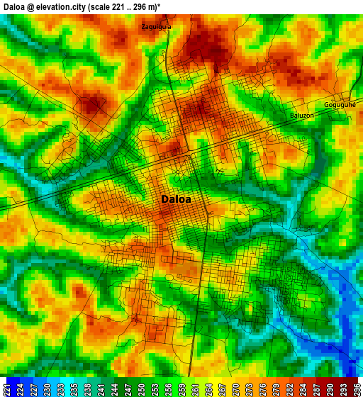
Below is the Elevation map of Daloa, which displays elevation range with different colors. Scale of the first map is from 221 to 296 m (725 to 971 ft) with average elevation of 260.6 meters (=855 ft) [note 1]
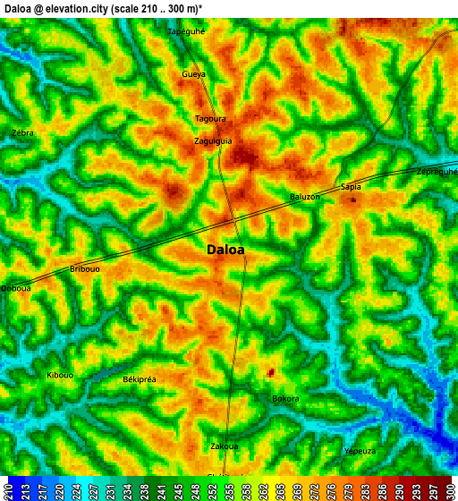
These maps also provides idea of topography and contour of this city, they are displayed at different zoom levels. More info about maps, scale and edge coordinates you can find below images.
| \ | Map #1 | Map #2 | Topo.Map |
| Scale [m] | 221..296 m | 210..300 m | × |
| Scale [ft] | 725..971 ft | 689..984 ft | × |
| Average | 260.6 m = 855 ft | 253.7 m = 832 ft | × |
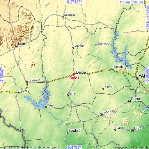
| Width | 9.7 km = 6 mi | 19.4 km = 12.1 mi | 310.4 km = 192.9 mi |
| Height | 9.7 km = 6 mi | 19.4 km = 12.1 mi | 310.5 km = 192.9 mi |
| ↑Max Latitude | 6.920977° | 6.9646° | 8.27129° |
| Latitude at center | 6.87735° | 6.87735° | 6.87735° |
| ↓Min Latitude | 6.833719° | 6.790084° | 5.4793° |
| ← Min Longitude | -6.494165° | -6.538111° | -7.85647° |
| Longitude center | -6.45022° | -6.45022° | -6.45022° |
| →Max Longitude | -6.406275° | -6.362329° | -5.04397° |
Nearby cities:
Cities around Daloa sort by population:
• Gagnoa elevation 202 m
99.6 km,  146°
146°
• Bouaflé 208 m
78.9 km,  80°
80°
• Sinfra 265 m
66 km,  115°
115°
• Issia 211 m
45.4 km,  199°
199°
• Duekoué 231 m
100.4 km,  261°
261°
• Zuénoula 207 m
75.7 km,  35°
35°
• Vavoua 276 m
56.2 km,  356°
356°
• Bangolo 264 m
115.3 km,  277°
277°
• Guibéroua 230 m
77.4 km,  156°
156°
• Kouibly 307 m
96.3 km,  295°
295°
• Buyo 229 m
90.2 km,  222°
222°
• Zoukougbeu 244 m
47.4 km,  254°
254°
Multilingual:
 En español:
Daloa elevación 262 m.
 En France:
Daloa élévation 262 m.


Sources and notes:
- [note 1] Map square and city borders are not equal. Map elevation data is calculated only from area inside that square.
- [src 1] Elevation data from geonames database provided with same terms of usage.
- [src 2] The elevation map of Daloa is generated using elevation data from NASA's 3 arcsec (90m) resolution SRTM data.
- [src 3] Base (background) map © OpenStreetMap contributors tiles are generated by Geofabrik and OpenTopoMap.
Copyright & License:
This Daloa Elevation Map is licensed under CC BY-SA. You may reuse any part from this page, if you give a proper credit by linking to this URL:
 More info on terms of use page.