Tanda elevation
Tanda (Zanzan), Ivory Coast elevation is 274 meters and Tanda elevation in feet is 899 ft above sea level [src 1]. Tanda is a seat of a third-order administrative division (feature code) with elevation that is 45 meters (148 ft) bigger than average city elevation in Ivory Coast.
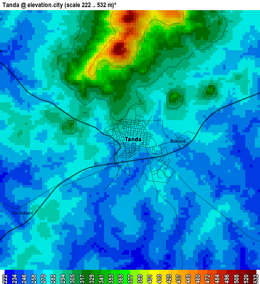
Below is the Elevation map of Tanda, which displays elevation range with different colors. Scale of the first map is from 222 to 532 m (728 to 1745 ft) with average elevation of 279.3 meters (=916 ft) [note 1]
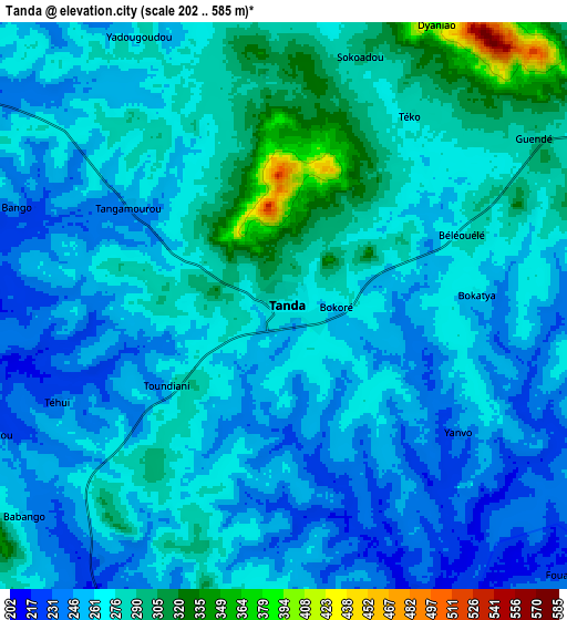
These maps also provides idea of topography and contour of this city, they are displayed at different zoom levels. More info about maps, scale and edge coordinates you can find below images.
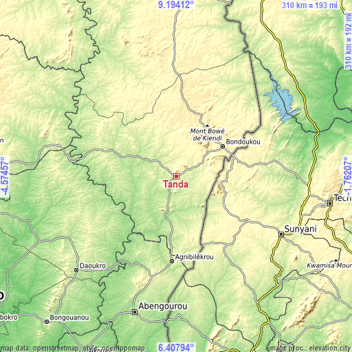
| \ | Map #1 | Map #2 | Topo.Map |
| Scale [m] | 222..532 m | 202..585 m | × |
| Scale [ft] | 728..1745 ft | 663..1919 ft | × |
| Average | 279.3 m = 916 ft | 269.1 m = 883 ft | × |
| Width | 9.68 km = 6 mi | 19.36 km = 12 mi | 309.8 km = 192.5 mi |
| Height | 9.68 km = 6 mi | 19.36 km = 12 mi | 309.8 km = 192.5 mi |
| ↑Max Latitude | 7.846886° | 7.890418° | 9.19412° |
| Latitude at center | 7.80335° | 7.80335° | 7.80335° |
| ↓Min Latitude | 7.759809° | 7.716264° | 6.40794° |
| ← Min Longitude | -3.212265° | -3.256211° | -4.57457° |
| Longitude center | -3.16832° | -3.16832° | -3.16832° |
| →Max Longitude | -3.124375° | -3.080429° | -1.76207° |
Nearby cities:
Cities around Tanda sort by population:
• Abengourou elevation 197 m
124.7 km,  196°
196°
• Bondoukou 350 m
48.4 km,  57°
57°
• Agnibilékrou 236 m
74.8 km,  183°
183°
• Daoukro 188 m
120.5 km,  226°
226°
• Arrah 143 m
153.6 km,  215°
215°
• Dabakala 254 m
152.1 km,  294°
294°
• M’Bahiakro 127 m
134.7 km,  253°
253°
• Prikro 213 m
92.9 km,  259°
259°
• Nassian 353 m
79.5 km,  335°
335°
• Sandégué 201 m
48.3 km, 290°
• Koun-Fao 196 m
36.3 km,  194°
194°
• Transua 195 m
32.9 km,  148°
148°
Multilingual:
 En español:
Tanda elevación 274 m.
 En France:
Tanda élévation 274 m.


Sources and notes:
- [note 1] Map square and city borders are not equal. Map elevation data is calculated only from area inside that square.
- [src 1] Elevation data from geonames database provided with same terms of usage.
- [src 2] The elevation map of Tanda is generated using elevation data from NASA's 3 arcsec (90m) resolution SRTM data.
- [src 3] Base (background) map © OpenStreetMap contributors tiles are generated by Geofabrik and OpenTopoMap.
Copyright & License:
This Tanda Elevation Map is licensed under CC BY-SA. You may reuse any part from this page, if you give a proper credit by linking to this URL:
 More info on terms of use page.