Pont-la-Ville elevation
Pont-la-Ville (Fribourg, Gruyère District), Switzerland elevation is 788 meters and Pont-la-Ville elevation in feet is 2585 ft above sea level [src 1]. Pont-la-Ville is a seat of a third-order administrative division (feature code) with elevation that is 240 meters (787 ft) bigger than average city elevation in Switzerland.
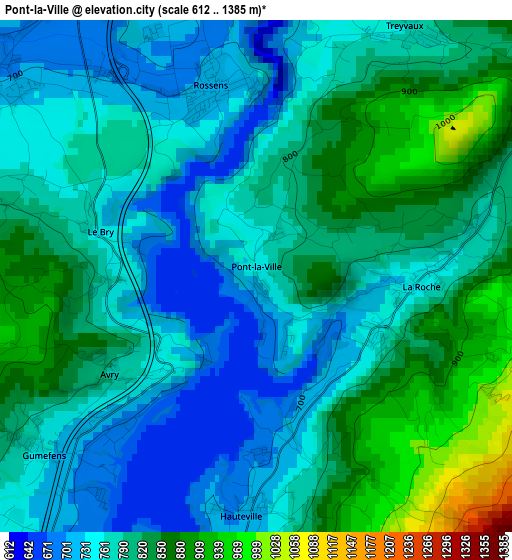
Below is the Elevation map of Pont-la-Ville, which displays elevation range with different colors. Scale of the first map is from 612 to 1385 m (2008 to 4544 ft) with average elevation of 794 meters (=2605 ft) [note 1]
These maps also provides idea of topography and contour of this city, they are displayed at different zoom levels. More info about maps, scale and edge coordinates you can find below images.
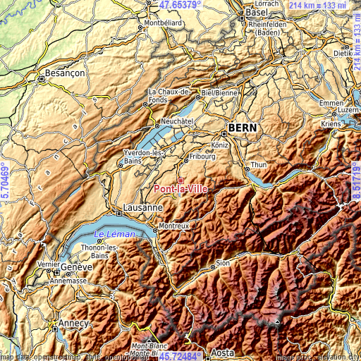
| \ | Map #1 | Topo.Map |
| Scale [m] | 612..1385 m | × |
| Scale [ft] | 2008..4544 ft | × |
| Average | 794 m = 2605 ft | × |
| Width | 6.7 km = 4.2 mi | 214.5 km = 133.3 mi |
| Height | 6.7 km = 4.2 mi | 214.5 km = 133.3 mi |
| ↑Max Latitude | 46.728061° | 47.65379° |
| Latitude at center | 46.69793° | 46.69793° |
| ↓Min Latitude | 46.667782° | 45.72484° |
| ← Min Longitude | 7.066995° | 5.70469° |
| Longitude center | 7.11094° | 7.11094° |
| →Max Longitude | 7.154885° | 8.51719° |
Nearby cities:
Cities around Pont-la-Ville sort by population:
• Bulle elevation 771 m
9.8 km,  204°
204°
• Villars-sur-Glâne 656 m
10.3 km,  2°
2°
• Marly 636 m
9.6 km,  25°
25°
• Riaz 729 m
7.2 km,  211°
211°
• Charmey 895 m
9.6 km,  154°
154°
• Marsens 759 m
6.1 km,  220°
220°
• Giffers 756 m
10.3 km,  46°
46°
• La Roche 750 m
2 km,  95°
95°
• Treyvaux 783 m
3.9 km, 31°
• Praroman 779 m
7.8 km,  40°
40°
• Ependes 751 m
6.8 km,  23°
23°
• Matran 597 m
9.8 km,  354°
354°
Multilingual:
 En español:
Pont-la-Ville elevación 788 m.
 En France:
Pont-la-Ville élévation 788 m.
 Auf Deutsch:
Pont-la-Ville höhe über dem Meeresspiegel ist 788 m.

Sources and notes:
- [note 1] Map square and city borders are not equal. Map elevation data is calculated only from area inside that square.
- [src 1] Elevation data from geonames database provided with same terms of usage.
- [src 2] The elevation map of Pont-la-Ville is generated using elevation data from NASA's 3 arcsec (90m) resolution SRTM data.
- [src 3] Base (background) map © OpenStreetMap contributors tiles are generated by Geofabrik and OpenTopoMap.
Copyright & License:
This Pont-la-Ville Elevation Map is licensed under CC BY-SA. You may reuse any part from this page, if you give a proper credit by linking to this URL:
 More info on terms of use page.