Marin-Epagnier elevation
Marin-Epagnier (Neuchâtel, Neuchâtel District), Switzerland elevation is 446 meters and Marin-Epagnier elevation in feet is 1463 ft above sea level [src 1]. Marin-Epagnier is a populated place (feature code) with elevation that is 102 meters (335 ft) smaller than average city elevation in Switzerland.
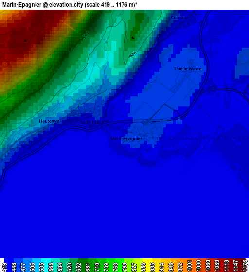
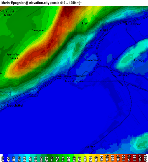
Below is the Elevation map of Marin-Epagnier, which displays elevation range with different colors. Scale of the first map is from 419 to 1176 m (1375 to 3858 ft) with average elevation of 504.4 meters (=1655 ft) [note 1]
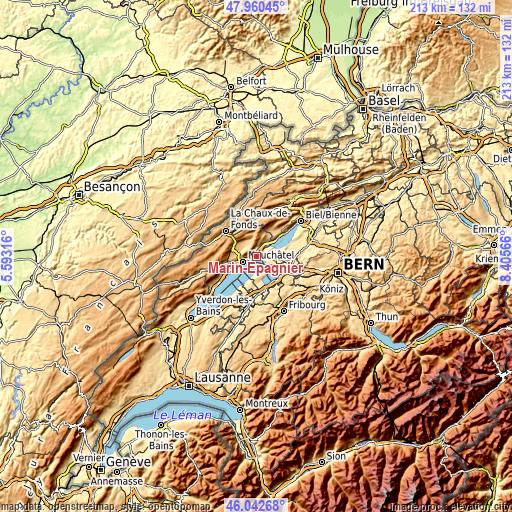
These maps also provides idea of topography and contour of this city, they are displayed at different zoom levels. More info about maps, scale and edge coordinates you can find below images.
| \ | Map #1 | Map #2 | Topo.Map |
| Scale [m] | 419..1176 m | 419..1259 m | × |
| Scale [ft] | 1375..3858 ft | 1375..4131 ft | × |
| Average | 504.4 m = 1655 ft | 559.6 m = 1836 ft | × |
| Width | 6.66 km = 4.1 mi | 13.33 km = 8.3 mi | 213.2 km = 132.5 mi |
| Height | 6.66 km = 4.1 mi | 13.33 km = 8.3 mi | 213.2 km = 132.5 mi |
| ↑Max Latitude | 47.040127° | 47.070066° | 47.96045° |
| Latitude at center | 47.01017° | 47.01017° | 47.01017° |
| ↓Min Latitude | 46.980197° | 46.950207° | 46.04268° |
| ← Min Longitude | 6.955465° | 6.911519° | 5.59316° |
| Longitude center | 6.99941° | 6.99941° | 6.99941° |
| →Max Longitude | 7.043355° | 7.087301° | 8.40566° |
Nearby cities:
Cities around Marin-Epagnier sort by population:
• Neuchâtel elevation 441 m
5.6 km,  248°
248°
• Peseux 539 m
8.8 km, 252°
• Le Landeron 433 m
7.5 km,  45°
45°
• La Neuveville 448 m
9.7 km, 50°
• Saint-Blaise 456 m
1 km,  303°
303°
• Ins 478 m
8.1 km,  93°
93°
• Cernier 825 m
9.2 km,  305°
305°
• Dombresson 741 m
7.5 km,  336°
336°
• Chézard-Saint-Martin 744 m
8 km,  321°
321°
• Cornaux 452 m
3.6 km,  24°
24°
• Grand-Savagnier 747 m
5.7 km, 323°
• Erlach 434 m
8.2 km,  64°
64°
Multilingual:
 En español:
Marin-Epagnier elevación 446 m.
 En France:
Marin-Epagnier élévation 446 m.
 Auf Deutsch:
Marin-Epagnier höhe über dem Meeresspiegel ist 446 m.

Sources and notes:
- [note 1] Map square and city borders are not equal. Map elevation data is calculated only from area inside that square.
- [src 1] Elevation data from geonames database provided with same terms of usage.
- [src 2] The elevation map of Marin-Epagnier is generated using elevation data from NASA's 3 arcsec (90m) resolution SRTM data.
- [src 3] Base (background) map © OpenStreetMap contributors tiles are generated by Geofabrik and OpenTopoMap.
Copyright & License:
This Marin-Epagnier Elevation Map is licensed under CC BY-SA. You may reuse any part from this page, if you give a proper credit by linking to this URL:
 More info on terms of use page.