Dänikon elevation
Dänikon (Zurich, Bezirk Dielsdorf), Switzerland elevation is 430 meters and Dänikon elevation in feet is 1411 ft above sea level [src 1]. Dänikon is a populated place (feature code) with elevation that is 118 meters (387 ft) smaller than average city elevation in Switzerland.
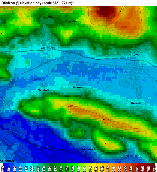
Below is the Elevation map of Dänikon, which displays elevation range with different colors. Scale of the first map is from 378 to 721 m (1240 to 2365 ft) with average elevation of 477.8 meters (=1568 ft) [note 1]
These maps also provides idea of topography and contour of this city, they are displayed at different zoom levels. More info about maps, scale and edge coordinates you can find below images.
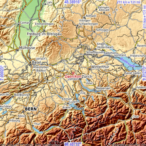
| \ | Map #1 | Topo.Map |
| Scale [m] | 378..721 m | × |
| Scale [ft] | 1240..2365 ft | × |
| Average | 477.8 m = 1568 ft | × |
| Width | 6.61 km = 4.1 mi | 211.5 km = 131.4 mi |
| Height | 6.61 km = 4.1 mi | 211.5 km = 131.4 mi |
| ↑Max Latitude | 47.476451° | 48.38916° |
| Latitude at center | 47.44674° | 47.44674° |
| ↓Min Latitude | 47.417012° | 46.48712° |
| ← Min Longitude | 8.362535° | 7.00023° |
| Longitude center | 8.40648° | 8.40648° |
| →Max Longitude | 8.450425° | 9.81273° |
Nearby cities:
Cities around Dänikon sort by population:
• Spreitenbach elevation 403 m
3.9 km,  227°
227°
• Würenlos 407 m
3.3 km,  261°
261°
• Geroldswil 403 m
2.8 km,  173°
173°
• Unterengstringen 421 m
4.8 km,  139°
139°
• Dietikon / Vorstadt 387 m
4.3 km,  189°
189°
• Sonnhalde 446 m
4.2 km,  79°
79°
• Otelfingen 439 m
1.9 km,  323°
323°
• Killwangen 411 m
4.5 km,  248°
248°
• Weiningen 419 m
3.7 km, 142°
• Dällikon / Dällikon (Dorf) 440 m
2.5 km,  107°
107°
• Regensdorf / Feldblumen-Riedthofstrasse 439 m
4.7 km,  104°
104°
• Regensdorf / Hofacher-Geeren 442 m
4.4 km, 106°
Multilingual:
 En español:
Dänikon elevación 430 m.
 En France:
Dänikon élévation 430 m.


Sources and notes:
- [note 1] Map square and city borders are not equal. Map elevation data is calculated only from area inside that square.
- [src 1] Elevation data from geonames database provided with same terms of usage.
- [src 2] The elevation map of Dänikon is generated using elevation data from NASA's 3 arcsec (90m) resolution SRTM data.
- [src 3] Base (background) map © OpenStreetMap contributors tiles are generated by Geofabrik and OpenTopoMap.
Copyright & License:
This Dänikon Elevation Map is licensed under CC BY-SA. You may reuse any part from this page, if you give a proper credit by linking to this URL:
 More info on terms of use page.