Amriswil elevation
Amriswil (Thurgau, Arbon District), Switzerland elevation is 451 meters and Amriswil elevation in feet is 1480 ft above sea level [src 1]. Amriswil is a populated place (feature code) with elevation that is 97 meters (318 ft) smaller than average city elevation in Switzerland.
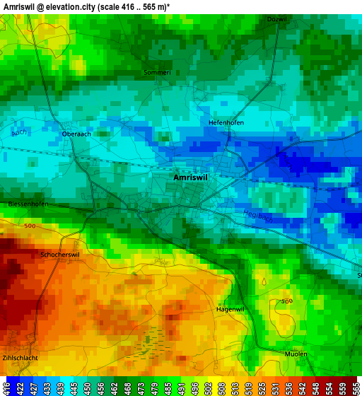
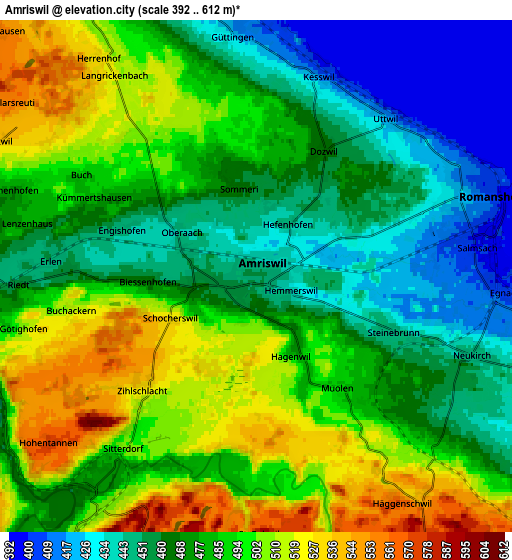
Below is the Elevation map of Amriswil, which displays elevation range with different colors. Scale of the first map is from 416 to 565 m (1365 to 1854 ft) with average elevation of 473.4 meters (=1553 ft) [note 1]
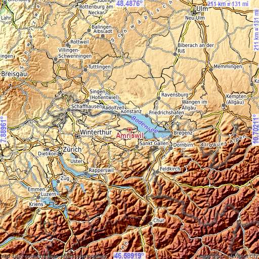
These maps also provides idea of topography and contour of this city, they are displayed at different zoom levels. More info about maps, scale and edge coordinates you can find below images.
| \ | Map #1 | Map #2 | Topo.Map |
| Scale [m] | 416..565 m | 392..612 m | × |
| Scale [ft] | 1365..1854 ft | 1286..2008 ft | × |
| Average | 473.4 m = 1553 ft | 479.2 m = 1572 ft | × |
| Width | 6.6 km = 4.1 mi | 13.19 km = 8.2 mi | 211.1 km = 131.2 mi |
| Height | 6.6 km = 4.1 mi | 13.19 km = 8.2 mi | 211.1 km = 131.2 mi |
| ↑Max Latitude | 47.576644° | 47.606281° | 48.4876° |
| Latitude at center | 47.54699° | 47.54699° | 47.54699° |
| ↓Min Latitude | 47.517319° | 47.487632° | 46.58919° |
| ← Min Longitude | 9.251915° | 9.207969° | 7.88961° |
| Longitude center | 9.29586° | 9.29586° | 9.29586° |
| →Max Longitude | 9.339805° | 9.383751° | 10.70211° |
Nearby cities:
Cities around Amriswil sort by population:
• Romanshorn elevation 401 m
6.6 km,  71°
71°
• Egnach 405 m
6.4 km,  94°
94°
• Sulgen 469 m
8.3 km,  264°
264°
• Erlen 459 m
4.6 km,  271°
271°
• Altnau 440 m
7.5 km,  340°
340°
• Uttwil 417 m
5.4 km,  39°
39°
• Güttingen 422 m
6.3 km,  354°
354°
• Salmsach 400 m
5.8 km,  81°
81°
• Häggenschwil 572 m
6.9 km,  147°
147°
• Muolen 491 m
3.6 km,  143°
143°
• Langrickenbach 522 m
6.3 km,  324°
324°
• Hohentannen 574 m
6.8 km,  231°
231°
Multilingual:
 En español:
Amriswil elevación 451 m.
 En France:
Amriswil élévation 451 m.
 Auf Deutsch:
Amriswil höhe über dem Meeresspiegel ist 451 m.

Sources and notes:
- [note 1] Map square and city borders are not equal. Map elevation data is calculated only from area inside that square.
- [src 1] Elevation data from geonames database provided with same terms of usage.
- [src 2] The elevation map of Amriswil is generated using elevation data from NASA's 3 arcsec (90m) resolution SRTM data.
- [src 3] Base (background) map © OpenStreetMap contributors tiles are generated by Geofabrik and OpenTopoMap.
Copyright & License:
This Amriswil Elevation Map is licensed under CC BY-SA. You may reuse any part from this page, if you give a proper credit by linking to this URL:
 More info on terms of use page.