Muolen elevation
Muolen (Saint Gallen, Wahlkreis St. Gallen), Switzerland elevation is 491 meters and Muolen elevation in feet is 1611 ft above sea level [src 1]. Muolen is a populated place (feature code) with elevation that is 57 meters (187 ft) smaller than average city elevation in Switzerland.
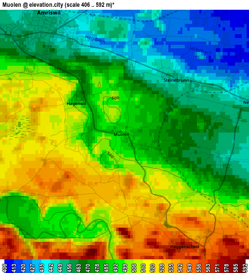
Below is the Elevation map of Muolen, which displays elevation range with different colors. Scale of the first map is from 406 to 592 m (1332 to 1942 ft) with average elevation of 488.8 meters (=1604 ft) [note 1]
These maps also provides idea of topography and contour of this city, they are displayed at different zoom levels. More info about maps, scale and edge coordinates you can find below images.
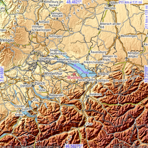
| \ | Map #1 | Topo.Map |
| Scale [m] | 406..592 m | × |
| Scale [ft] | 1332..1942 ft | × |
| Average | 488.8 m = 1604 ft | × |
| Width | 6.6 km = 4.1 mi | 211.2 km = 131.2 mi |
| Height | 6.6 km = 4.1 mi | 211.2 km = 131.2 mi |
| ↑Max Latitude | 47.550689° | 48.4621° |
| Latitude at center | 47.52102° | 47.52102° |
| ↓Min Latitude | 47.491334° | 46.56275° |
| ← Min Longitude | 9.280895° | 7.91859° |
| Longitude center | 9.32484° | 9.32484° |
| →Max Longitude | 9.368785° | 10.73109° |
Nearby cities:
Cities around Muolen sort by population:
• Arbon elevation 408 m
8.2 km,  93°
93°
• Amriswil 451 m
3.6 km,  323°
323°
• Romanshorn 401 m
6.4 km,  39°
39°
• Wittenbach 615 m
8.1 km,  145°
145°
• Egnach 405 m
4.8 km,  60°
60°
• Waldkirch 627 m
6.5 km,  206°
206°
• Erlen 459 m
7.4 km,  293°
293°
• Roggwil 438 m
5.8 km,  113°
113°
• Uttwil 417 m
7.2 km,  9°
9°
• Salmsach 400 m
5.1 km, 43°
• Häggenschwil 572 m
3.3 km, 152°
• Hohentannen 574 m
7.6 km,  259°
259°
Multilingual:
 En español:
Muolen elevación 491 m.
 En France:
Muolen élévation 491 m.


Sources and notes:
- [note 1] Map square and city borders are not equal. Map elevation data is calculated only from area inside that square.
- [src 1] Elevation data from geonames database provided with same terms of usage.
- [src 2] The elevation map of Muolen is generated using elevation data from NASA's 3 arcsec (90m) resolution SRTM data.
- [src 3] Base (background) map © OpenStreetMap contributors tiles are generated by Geofabrik and OpenTopoMap.
Copyright & License:
This Muolen Elevation Map is licensed under CC BY-SA. You may reuse any part from this page, if you give a proper credit by linking to this URL:
 More info on terms of use page.