Biberist elevation
Biberist (Solothurn, Bezirk Wasseramt), Switzerland elevation is 449 meters and Biberist elevation in feet is 1473 ft above sea level [src 1]. Biberist is a populated place (feature code) with elevation that is 99 meters (325 ft) smaller than average city elevation in Switzerland.
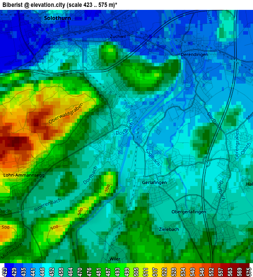
Below is the Elevation map of Biberist, which displays elevation range with different colors. Scale of the first map is from 423 to 575 m (1388 to 1886 ft) with average elevation of 463 meters (=1519 ft) [note 1]
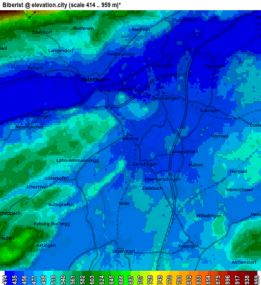
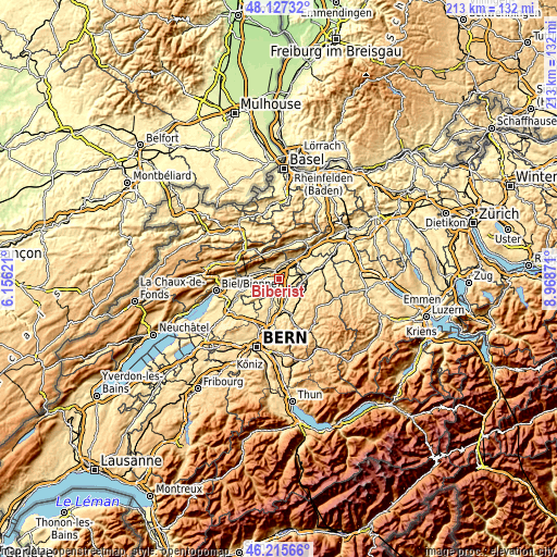
These maps also provides idea of topography and contour of this city, they are displayed at different zoom levels. More info about maps, scale and edge coordinates you can find below images.
| \ | Map #1 | Map #2 | Topo.Map |
| Scale [m] | 423..575 m | 414..959 m | × |
| Scale [ft] | 1388..1886 ft | 1358..3146 ft | × |
| Average | 463 m = 1519 ft | 482 m = 1581 ft | × |
| Width | 6.64 km = 4.1 mi | 13.28 km = 8.3 mi | 212.6 km = 132.1 mi |
| Height | 6.64 km = 4.1 mi | 13.28 km = 8.3 mi | 212.5 km = 132 mi |
| ↑Max Latitude | 47.209951° | 47.239795° | 48.12732° |
| Latitude at center | 47.18009° | 47.18009° | 47.18009° |
| ↓Min Latitude | 47.150212° | 47.120317° | 46.21566° |
| ← Min Longitude | 7.518515° | 7.474569° | 6.15621° |
| Longitude center | 7.56246° | 7.56246° | 7.56246° |
| →Max Longitude | 7.606405° | 7.650351° | 8.96871° |
Nearby cities:
Cities around Biberist sort by population:
• Solothurn elevation 440 m
3.6 km,  328°
328°
• Zuchwil 434 m
2.4 km,  7°
7°
• Derendingen 439 m
2.8 km,  43°
43°
• Gerlafingen 451 m
1.3 km,  143°
143°
• Utzenstorf 473 m
5.3 km,  187°
187°
• Langendorf 483 m
5.7 km,  320°
320°
• Luterbach 433 m
4.2 km,  23°
23°
• Subingen 441 m
4.8 km,  64°
64°
• Bätterkinden 474 m
5.7 km,  198°
198°
• Deitingen 454 m
5.8 km,  47°
47°
• Riedholz 474 m
5.7 km,  4°
4°
• Kriegstetten 455 m
2.8 km,  103°
103°
Multilingual:
 En español:
Biberist elevación 449 m.
 En France:
Biberist élévation 449 m.
 Auf Deutsch:
Biberist höhe über dem Meeresspiegel ist 449 m.

Sources and notes:
- [note 1] Map square and city borders are not equal. Map elevation data is calculated only from area inside that square.
- [src 1] Elevation data from geonames database provided with same terms of usage.
- [src 2] The elevation map of Biberist is generated using elevation data from NASA's 3 arcsec (90m) resolution SRTM data.
- [src 3] Base (background) map © OpenStreetMap contributors tiles are generated by Geofabrik and OpenTopoMap.
Copyright & License:
This Biberist Elevation Map is licensed under CC BY-SA. You may reuse any part from this page, if you give a proper credit by linking to this URL:
 More info on terms of use page.