Solothurn elevation
Solothurn, Switzerland elevation is 440 meters and Solothurn elevation in feet is 1444 ft above sea level [src 1]. Solothurn is a seat of a first-order administrative division (feature code) with elevation that is 108 meters (354 ft) smaller than average city elevation in Switzerland.
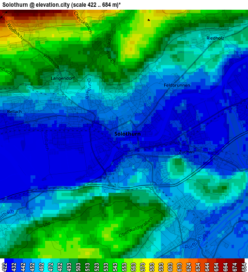
Below is the Elevation map of Solothurn, which displays elevation range with different colors. Scale of the first map is from 422 to 684 m (1385 to 2244 ft) with average elevation of 477.6 meters (=1567 ft) [note 1]
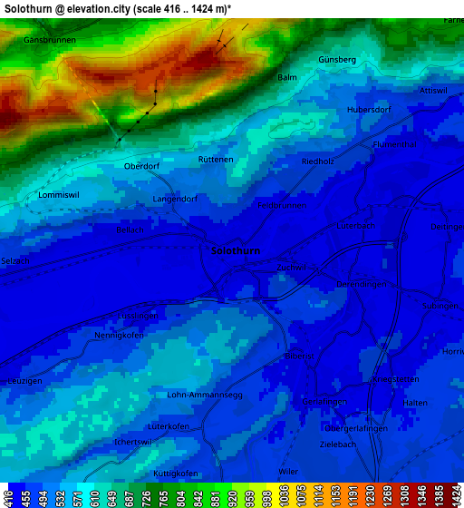
These maps also provides idea of topography and contour of this city, they are displayed at different zoom levels. More info about maps, scale and edge coordinates you can find below images.
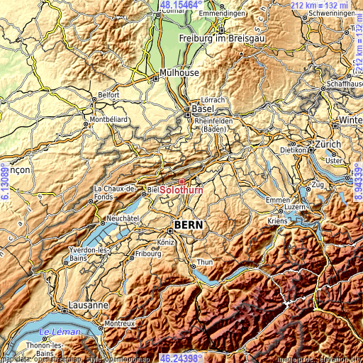
| \ | Map #1 | Map #2 | Topo.Map |
| Scale [m] | 422..684 m | 416..1424 m | × |
| Scale [ft] | 1385..2244 ft | 1365..4672 ft | × |
| Average | 477.6 m = 1567 ft | 572 m = 1877 ft | × |
| Width | 6.64 km = 4.1 mi | 13.28 km = 8.3 mi | 212.4 km = 132 mi |
| Height | 6.64 km = 4.1 mi | 13.28 km = 8.3 mi | 212.4 km = 132 mi |
| ↑Max Latitude | 47.237755° | 47.267584° | 48.15464° |
| Latitude at center | 47.20791° | 47.20791° | 47.20791° |
| ↓Min Latitude | 47.178048° | 47.148169° | 46.24398° |
| ← Min Longitude | 7.493195° | 7.449249° | 6.13089° |
| Longitude center | 7.53714° | 7.53714° | 7.53714° |
| →Max Longitude | 7.581085° | 7.625031° | 8.94339° |
Nearby cities:
Cities around Solothurn sort by population:
• Zuchwil elevation 434 m
2.3 km,  107°
107°
• Biberist 449 m
3.6 km,  148°
148°
• Derendingen 439 m
4 km, 105°
• Gerlafingen 451 m
4.9 km, 147°
• Langendorf 483 m
2.1 km,  307°
307°
• Luterbach 433 m
3.7 km,  78°
78°
• Selzach 453 m
6.2 km,  267°
267°
• Subingen 441 m
6.3 km,  99°
99°
• Deitingen 454 m
6.2 km, 82°
• Riedholz 474 m
3.5 km,  41°
41°
• Leuzigen 455 m
7.1 km,  238°
238°
• Kriegstetten 455 m
5.9 km,  128°
128°
Multilingual:
 En español:
Soleura elevación 440 m.
 En France:
Soleure élévation 440 m.
 Auf Deutsch:
Solothurn höhe über dem Meeresspiegel ist 440 m.

Sources and notes:
- [note 1] Map square and city borders are not equal. Map elevation data is calculated only from area inside that square.
- [src 1] Elevation data from geonames database provided with same terms of usage.
- [src 2] The elevation map of Solothurn is generated using elevation data from NASA's 3 arcsec (90m) resolution SRTM data.
- [src 3] Base (background) map © OpenStreetMap contributors tiles are generated by Geofabrik and OpenTopoMap.
Copyright & License:
This Solothurn Elevation Map is licensed under CC BY-SA. You may reuse any part from this page, if you give a proper credit by linking to this URL:
 More info on terms of use page.