Biel/Bienne elevation
Biel/Bienne (Bern, Biel/Bienne District), Switzerland elevation is 439 meters and Biel/Bienne elevation in feet is 1440 ft above sea level [src 1]. Biel/Bienne is a seat of a second-order administrative division (feature code) with elevation that is 109 meters (358 ft) smaller than average city elevation in Switzerland.
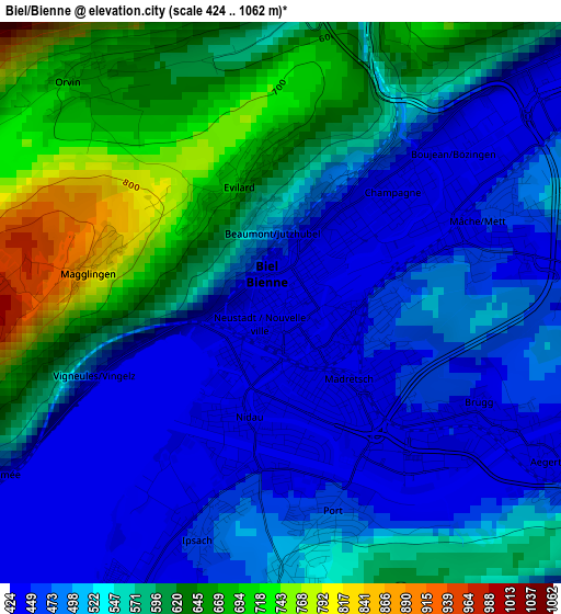
Below is the Elevation map of Biel/Bienne, which displays elevation range with different colors. Scale of the first map is from 424 to 1062 m (1391 to 3484 ft) with average elevation of 543.7 meters (=1784 ft) [note 1]
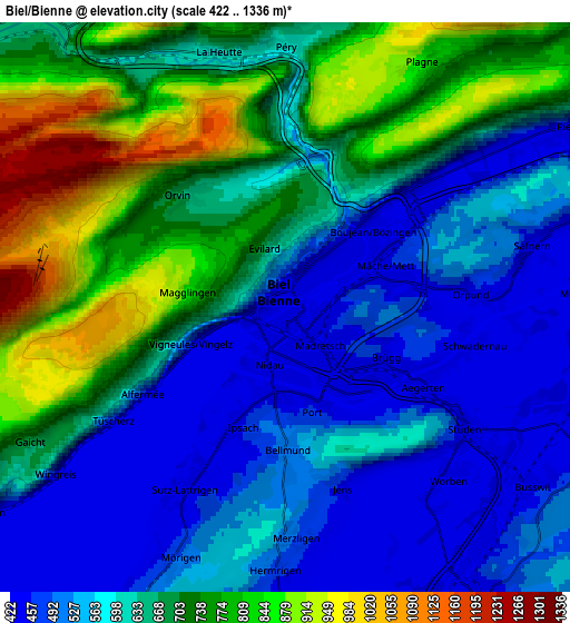
These maps also provides idea of topography and contour of this city, they are displayed at different zoom levels. More info about maps, scale and edge coordinates you can find below images.
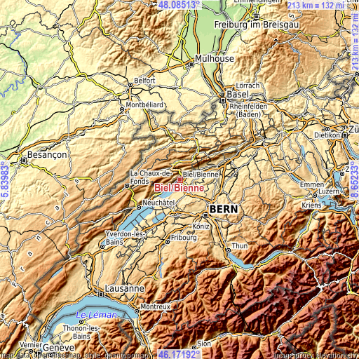
| \ | Map #1 | Map #2 | Topo.Map |
| Scale [m] | 424..1062 m | 422..1336 m | × |
| Scale [ft] | 1391..3484 ft | 1385..4383 ft | × |
| Average | 543.7 m = 1784 ft | 636 m = 2087 ft | × |
| Width | 6.65 km = 4.1 mi | 13.3 km = 8.3 mi | 212.7 km = 132.2 mi |
| Height | 6.65 km = 4.1 mi | 13.3 km = 8.3 mi | 212.7 km = 132.2 mi |
| ↑Max Latitude | 47.167015° | 47.196884° | 48.08513° |
| Latitude at center | 47.13713° | 47.13713° | 47.13713° |
| ↓Min Latitude | 47.107228° | 47.077309° | 46.17192° |
| ← Min Longitude | 7.202135° | 7.158189° | 5.83983° |
| Longitude center | 7.24608° | 7.24608° | 7.24608° |
| →Max Longitude | 7.290025° | 7.333971° | 8.65233° |
Nearby cities:
Cities around Biel/Bienne sort by population:
• Lyss elevation 445 m
8.4 km,  146°
146°
• Nidau 437 m
1.4 km,  198°
198°
• Brügg 434 m
2.9 km,  121°
121°
• Pieterlen 440 m
8.1 km,  58°
58°
• Täuffelen 490 m
8.6 km, 204°
• Orpund 437 m
4.7 km,  87°
87°
• Evilard 707 m
1.6 km,  340°
340°
• Worben 439 m
5.3 km,  135°
135°
• Péry 634 m
6.3 km,  2°
2°
• Bellmund 504 m
3.2 km,  180°
180°
• Meinisberg 446 m
8.1 km,  72°
72°
• Orvin 673 m
3.6 km,  316°
316°
Multilingual:
 En español:
Biel-Bienne elevación 439 m.
 En France:
Bienne élévation 439 m.


Sources and notes:
- [note 1] Map square and city borders are not equal. Map elevation data is calculated only from area inside that square.
- [src 1] Elevation data from geonames database provided with same terms of usage.
- [src 2] The elevation map of Biel/Bienne is generated using elevation data from NASA's 3 arcsec (90m) resolution SRTM data.
- [src 3] Base (background) map © OpenStreetMap contributors tiles are generated by Geofabrik and OpenTopoMap.
Copyright & License:
This Biel/Bienne Elevation Map is licensed under CC BY-SA. You may reuse any part from this page, if you give a proper credit by linking to this URL:
 More info on terms of use page.