Fribourg elevation
Fribourg, Switzerland elevation is 627 meters and Fribourg elevation in feet is 2057 ft above sea level [src 1]. Fribourg is a seat of a first-order administrative division (feature code) with elevation that is 79 meters (259 ft) bigger than average city elevation in Switzerland.
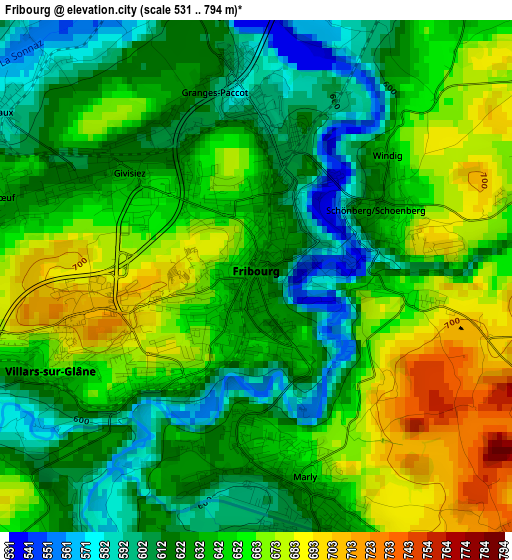
Below is the Elevation map of Fribourg, which displays elevation range with different colors. Scale of the first map is from 531 to 794 m (1742 to 2605 ft) with average elevation of 640.4 meters (=2101 ft) [note 1]
These maps also provides idea of topography and contour of this city, they are displayed at different zoom levels. More info about maps, scale and edge coordinates you can find below images.
| \ | Map #1 | Map #2 | Topo.Map |
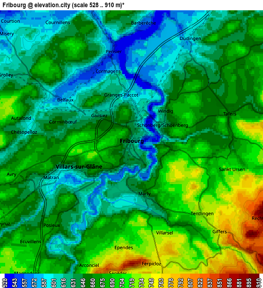
| Scale [m] | 531..794 m | 528..910 m | × |
| Scale [ft] | 1742..2605 ft | 1732..2986 ft | × |
| Average | 640.4 m = 2101 ft | 660.2 m = 2166 ft | × |
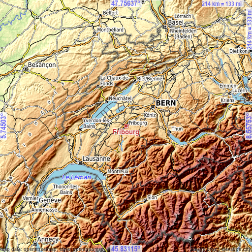
| Width | 6.69 km = 4.2 mi | 13.38 km = 8.3 mi | 214.1 km = 133 mi |
| Height | 6.69 km = 4.2 mi | 13.38 km = 8.3 mi | 214.1 km = 133 mi |
| ↑Max Latitude | 46.832443° | 46.862499° | 47.75637° |
| Latitude at center | 46.80237° | 46.80237° | 46.80237° |
| ↓Min Latitude | 46.77228° | 46.742174° | 45.83115° |
| ← Min Longitude | 7.107335° | 7.063389° | 5.74503° |
| Longitude center | 7.15128° | 7.15128° | 7.15128° |
| →Max Longitude | 7.195225° | 7.239171° | 8.55753° |
Nearby cities:
Cities around Fribourg sort by population:
• Villars-sur-Glâne elevation 656 m
2.9 km,  243°
243°
• Marly 636 m
3.1 km,  160°
160°
• Düdingen 600 m
6 km,  30°
30°
• Givisiez 645 m
2.2 km,  299°
299°
• Tafers 661 m
5.3 km,  74°
74°
• Belfaux 584 m
4 km, 302°
• Corminboeuf 646 m
3.6 km,  284°
284°
• Giffers 756 m
6.2 km,  135°
135°
• Avry-sur-Matran 697 m
6.6 km,  255°
255°
• Praroman 779 m
6 km, 160°
• Ependes 751 m
5.4 km,  184°
184°
• Matran 597 m
4.5 km,  245°
245°
Multilingual:
 En español:
Friburgo elevación 627 m.
 En France:
Fribourg élévation 627 m.
 Auf Deutsch:
Freiburg höhe über dem Meeresspiegel ist 627 m.

Sources and notes:
- [note 1] Map square and city borders are not equal. Map elevation data is calculated only from area inside that square.
- [src 1] Elevation data from geonames database provided with same terms of usage.
- [src 2] The elevation map of Fribourg is generated using elevation data from NASA's 3 arcsec (90m) resolution SRTM data.
- [src 3] Base (background) map © OpenStreetMap contributors tiles are generated by Geofabrik and OpenTopoMap.
Copyright & License:
This Fribourg Elevation Map is licensed under CC BY-SA. You may reuse any part from this page, if you give a proper credit by linking to this URL:
 More info on terms of use page.