Gland elevation
Gland (Vaud, Nyon District), Switzerland elevation is 416 meters and Gland elevation in feet is 1365 ft above sea level [src 1]. Gland is a populated place (feature code) with elevation that is 132 meters (433 ft) smaller than average city elevation in Switzerland.
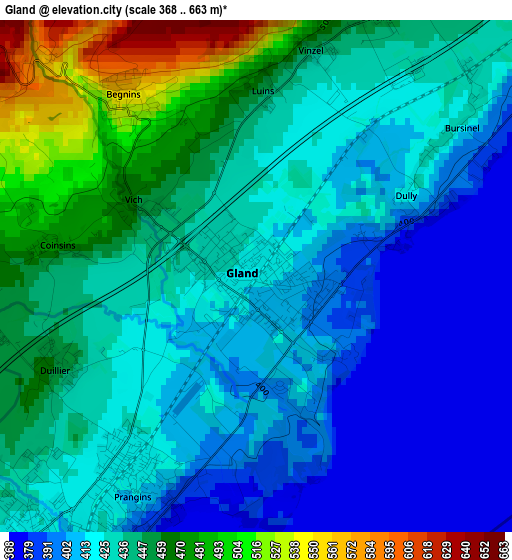
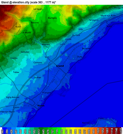
Below is the Elevation map of Gland, which displays elevation range with different colors. Scale of the first map is from 368 to 663 m (1207 to 2175 ft) with average elevation of 431.2 meters (=1415 ft) [note 1]
These maps also provides idea of topography and contour of this city, they are displayed at different zoom levels. More info about maps, scale and edge coordinates you can find below images.

| \ | Map #1 | Map #2 | Topo.Map |
| Scale [m] | 368..663 m | 363..1177 m | × |
| Scale [ft] | 1207..2175 ft | 1191..3862 ft | × |
| Average | 431.2 m = 1415 ft | 497.6 m = 1633 ft | × |
| Width | 6.74 km = 4.2 mi | 13.47 km = 8.4 mi | 215.6 km = 134 mi |
| Height | 6.74 km = 4.2 mi | 13.47 km = 8.4 mi | 215.6 km = 134 mi |
| ↑Max Latitude | 46.451106° | 46.481374° | 47.38161° |
| Latitude at center | 46.42082° | 46.42082° | 46.42082° |
| ↓Min Latitude | 46.390518° | 46.360198° | 45.44279° |
| ← Min Longitude | 6.226155° | 6.182209° | 4.86385° |
| Longitude center | 6.2701° | 6.2701° | 6.2701° |
| →Max Longitude | 6.314045° | 6.357991° | 7.67635° |
Nearby cities:
Cities around Gland sort by population:
• Nyon elevation 401 m
4.8 km,  209°
209°
• Rolle 389 m
6.5 km,  50°
50°
• Prangins 413 m
3.3 km, 208°
• Arzier 869 m
6.4 km,  312°
312°
• Saint-Cergue 1043 m
9.1 km,  287°
287°
• Genolier 546 m
4.3 km, 292°
• Gimel 731 m
10.3 km,  16°
16°
• Begnins 550 m
2.9 km,  323°
323°
• Perroy 413 m
8.2 km, 51°
• Le Vaud 814 m
6.8 km,  337°
337°
• Trélex 499 m
4.8 km,  262°
262°
• Chéserex 502 m
7.7 km,  251°
251°
Multilingual:
 En español:
Gland elevación 416 m.
 En France:
Gland élévation 416 m.
 Auf Deutsch:
Gland VD höhe über dem Meeresspiegel ist 416 m.

Sources and notes:
- [note 1] Map square and city borders are not equal. Map elevation data is calculated only from area inside that square.
- [src 1] Elevation data from geonames database provided with same terms of usage.
- [src 2] The elevation map of Gland is generated using elevation data from NASA's 3 arcsec (90m) resolution SRTM data.
- [src 3] Base (background) map © OpenStreetMap contributors tiles are generated by Geofabrik and OpenTopoMap.
Copyright & License:
This Gland Elevation Map is licensed under CC BY-SA. You may reuse any part from this page, if you give a proper credit by linking to this URL:
 More info on terms of use page.