Grenchen elevation
Grenchen (Solothurn, Bezirk Lebern), Switzerland elevation is 454 meters and Grenchen elevation in feet is 1490 ft above sea level [src 1]. Grenchen is a populated place (feature code) with elevation that is 94 meters (308 ft) smaller than average city elevation in Switzerland.
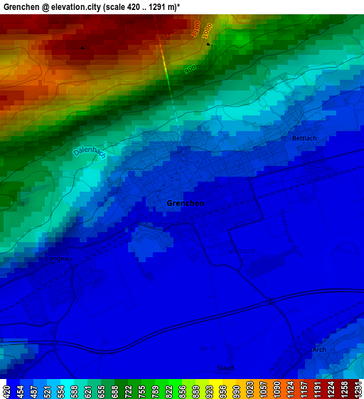
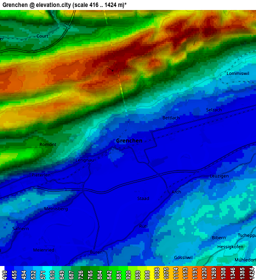
Below is the Elevation map of Grenchen, which displays elevation range with different colors. Scale of the first map is from 420 to 1291 m (1378 to 4236 ft) with average elevation of 587.3 meters (=1927 ft) [note 1]
These maps also provides idea of topography and contour of this city, they are displayed at different zoom levels. More info about maps, scale and edge coordinates you can find below images.
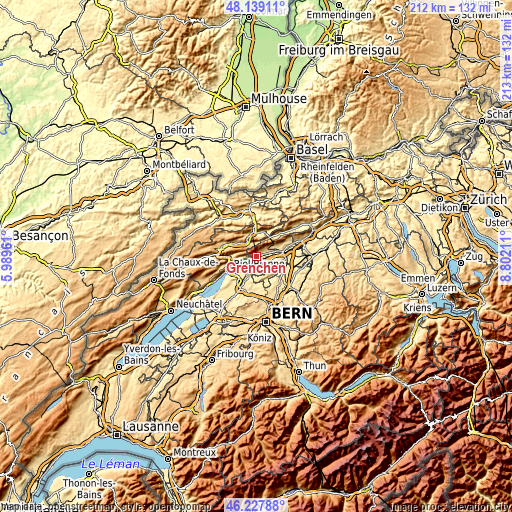
| \ | Map #1 | Map #2 | Topo.Map |
| Scale [m] | 420..1291 m | 416..1424 m | × |
| Scale [ft] | 1378..4236 ft | 1365..4672 ft | × |
| Average | 587.3 m = 1927 ft | 678.5 m = 2226 ft | × |
| Width | 6.64 km = 4.1 mi | 13.28 km = 8.3 mi | 212.5 km = 132 mi |
| Height | 6.64 km = 4.1 mi | 13.28 km = 8.3 mi | 212.5 km = 132 mi |
| ↑Max Latitude | 47.221954° | 47.251792° | 48.13911° |
| Latitude at center | 47.1921° | 47.1921° | 47.1921° |
| ↓Min Latitude | 47.162229° | 47.132341° | 46.22788° |
| ← Min Longitude | 7.351915° | 7.307969° | 5.98961° |
| Longitude center | 7.39586° | 7.39586° | 7.39586° |
| →Max Longitude | 7.439805° | 7.483751° | 8.80211° |
Nearby cities:
Cities around Grenchen sort by population:
• Moutier elevation 536 m
9.8 km,  348°
348°
• Lengnau 442 m
2.4 km,  240°
240°
• Bettlach 469 m
2.3 km,  66°
66°
• Langendorf 483 m
9.5 km, 71°
• Pieterlen 440 m
4.8 km,  246°
246°
• Selzach 453 m
4.7 km, 71°
• Orpund 437 m
8.9 km,  228°
228°
• Bévilard 696 m
9.9 km,  300°
300°
• Arch 475 m
4 km,  137°
137°
• Court 667 m
6.9 km,  319°
319°
• Meinisberg 446 m
5.1 km, 225°
• Leuzigen 455 m
5.1 km,  112°
112°
Multilingual:
 En español:
Grenchen elevación 454 m.
 En France:
Granges élévation 454 m.
 Auf Deutsch:
Grenchen höhe über dem Meeresspiegel ist 454 m.

Sources and notes:
- [note 1] Map square and city borders are not equal. Map elevation data is calculated only from area inside that square.
- [src 1] Elevation data from geonames database provided with same terms of usage.
- [src 2] The elevation map of Grenchen is generated using elevation data from NASA's 3 arcsec (90m) resolution SRTM data.
- [src 3] Base (background) map © OpenStreetMap contributors tiles are generated by Geofabrik and OpenTopoMap.
Copyright & License:
This Grenchen Elevation Map is licensed under CC BY-SA. You may reuse any part from this page, if you give a proper credit by linking to this URL:
 More info on terms of use page.