Moutier elevation
Moutier (Bern, Jura bernois), Switzerland elevation is 536 meters and Moutier elevation in feet is 1759 ft above sea level [src 1]. Moutier is a seat of a third-order administrative division (feature code) with elevation that is 12 meters (39 ft) smaller than average city elevation in Switzerland.
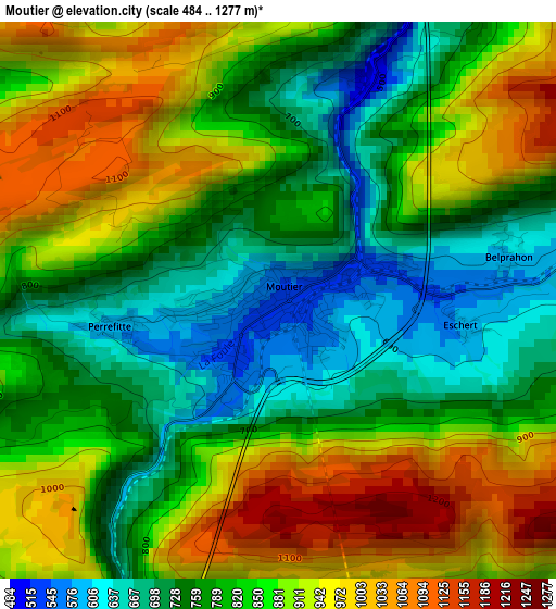
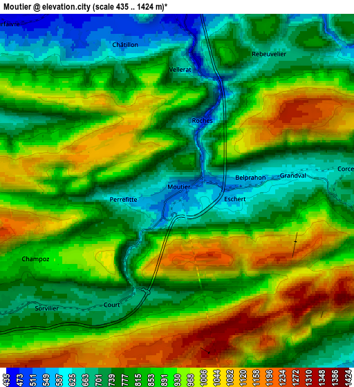
Below is the Elevation map of Moutier, which displays elevation range with different colors. Scale of the first map is from 484 to 1277 m (1588 to 4190 ft) with average elevation of 839.9 meters (=2756 ft) [note 1]
These maps also provides idea of topography and contour of this city, they are displayed at different zoom levels. More info about maps, scale and edge coordinates you can find below images.
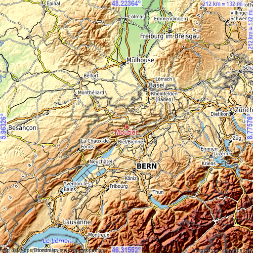
| \ | Map #1 | Map #2 | Topo.Map |
| Scale [m] | 484..1277 m | 435..1424 m | × |
| Scale [ft] | 1588..4190 ft | 1427..4672 ft | × |
| Average | 839.9 m = 2756 ft | 866.1 m = 2842 ft | × |
| Width | 6.63 km = 4.1 mi | 13.26 km = 8.2 mi | 212.2 km = 131.9 mi |
| Height | 6.63 km = 4.1 mi | 13.26 km = 8.2 mi | 212.2 km = 131.9 mi |
| ↑Max Latitude | 47.307986° | 47.337775° | 48.22364° |
| Latitude at center | 47.27818° | 47.27818° | 47.27818° |
| ↓Min Latitude | 47.248357° | 47.218518° | 46.31552° |
| ← Min Longitude | 7.325565° | 7.281619° | 5.96326° |
| Longitude center | 7.36951° | 7.36951° | 7.36951° |
| →Max Longitude | 7.413455° | 7.457401° | 8.77576° |
Nearby cities:
Cities around Moutier sort by population:
• Grenchen elevation 454 m
9.8 km,  168°
168°
• Delémont 432 m
9.8 km,  348°
348°
• Bettlach 469 m
9.6 km,  154°
154°
• Courroux 417 m
9.2 km,  1°
1°
• Selzach 453 m
10.4 km,  141°
141°
• Courrendlin 436 m
6.7 km, 1°
• Courtételle 440 m
8 km,  330°
330°
• Malleray 700 m
8.5 km,  238°
238°
• Vicques 453 m
8.6 km,  22°
22°
• Bévilard 696 m
8 km,  234°
234°
• Courfaivre 457 m
9.1 km,  313°
313°
• Court 667 m
5 km,  210°
210°
Multilingual:
 En español:
Moutier elevación 536 m.
 En France:
Moutier élévation 536 m.


Sources and notes:
- [note 1] Map square and city borders are not equal. Map elevation data is calculated only from area inside that square.
- [src 1] Elevation data from geonames database provided with same terms of usage.
- [src 2] The elevation map of Moutier is generated using elevation data from NASA's 3 arcsec (90m) resolution SRTM data.
- [src 3] Base (background) map © OpenStreetMap contributors tiles are generated by Geofabrik and OpenTopoMap.
Copyright & License:
This Moutier Elevation Map is licensed under CC BY-SA. You may reuse any part from this page, if you give a proper credit by linking to this URL:
 More info on terms of use page.