Küssnacht elevation
Küssnacht (Schwyz, Bezirk Küssnacht), Switzerland elevation is 440 meters and Küssnacht elevation in feet is 1444 ft above sea level [src 1]. Küssnacht is a seat of a second-order administrative division (feature code) with elevation that is 108 meters (354 ft) smaller than average city elevation in Switzerland.
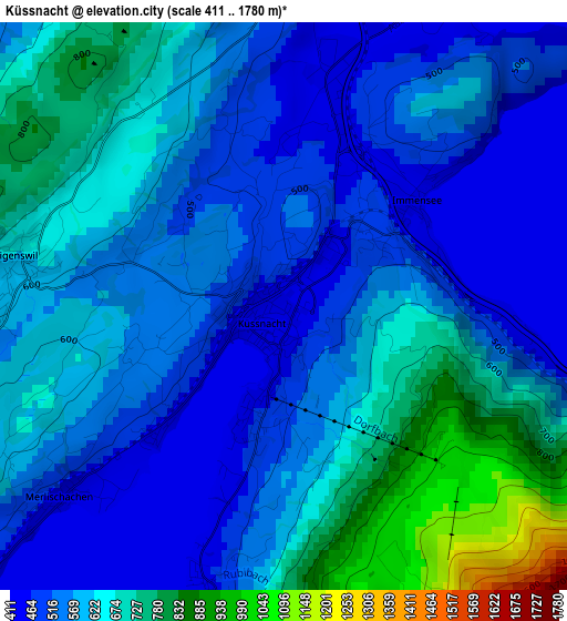
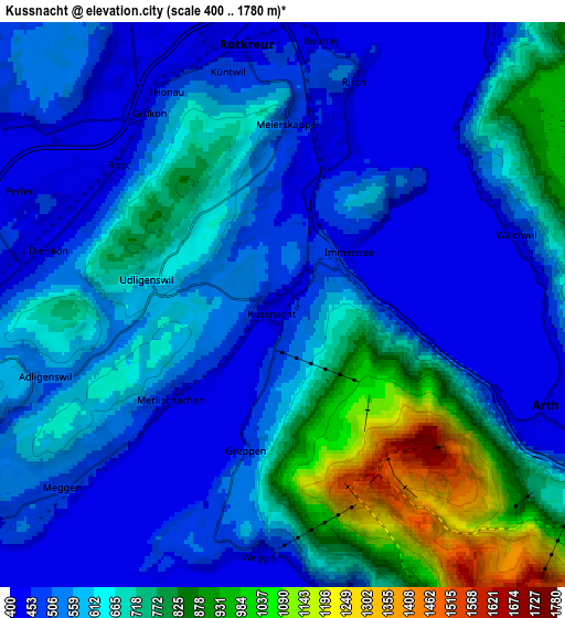
Below is the Elevation map of Küssnacht, which displays elevation range with different colors. Scale of the first map is from 411 to 1780 m (1348 to 5840 ft) with average elevation of 595.8 meters (=1955 ft) [note 1]
These maps also provides idea of topography and contour of this city, they are displayed at different zoom levels. More info about maps, scale and edge coordinates you can find below images.
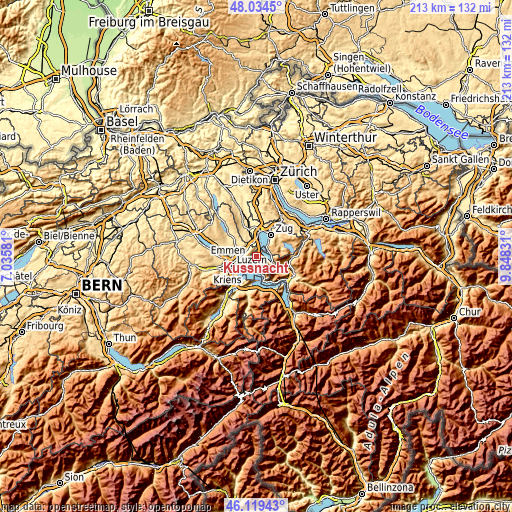
| \ | Map #1 | Map #2 | Topo.Map |
| Scale [m] | 411..1780 m | 400..1780 m | × |
| Scale [ft] | 1348..5840 ft | 1312..5840 ft | × |
| Average | 595.8 m = 1955 ft | 615.5 m = 2019 ft | × |
| Width | 6.65 km = 4.1 mi | 13.31 km = 8.3 mi | 212.9 km = 132.3 mi |
| Height | 6.65 km = 4.1 mi | 13.31 km = 8.3 mi | 212.9 km = 132.3 mi |
| ↑Max Latitude | 47.115484° | 47.145382° | 48.0345° |
| Latitude at center | 47.08557° | 47.08557° | 47.08557° |
| ↓Min Latitude | 47.055639° | 47.025691° | 46.11943° |
| ← Min Longitude | 8.398115° | 8.354169° | 7.03581° |
| Longitude center | 8.44206° | 8.44206° | 8.44206° |
| →Max Longitude | 8.486005° | 8.529951° | 9.84831° |
Nearby cities:
Cities around Küssnacht sort by population:
• Ebikon elevation 437 m
7.7 km,  264°
264°
• Rotkreuz 427 m
6.4 km,  352°
352°
• Arth 425 m
6.6 km,  111°
111°
• Meggen 476 m
6.7 km,  229°
229°
• Adligenswil 547 m
6.5 km,  249°
249°
• Buchrain 458 m
7.3 km,  279°
279°
• Root 426 m
5.1 km,  309°
309°
• Weggis 439 m
6 km,  187°
187°
• Walchwil 479 m
5.9 km,  72°
72°
• Udligenswil 621 m
3 km, 279°
• Inwil 427 m
8.3 km,  302°
302°
• Meierskappel 503 m
4.4 km,  0°
0°
Multilingual:
 En español:
Küssnacht am Rigi elevación 440 m.
 En France:
Küssnacht am Rigi élévation 440 m.
 Auf Deutsch:
Küssnacht SZ höhe über dem Meeresspiegel ist 440 m.

Sources and notes:
- [note 1] Map square and city borders are not equal. Map elevation data is calculated only from area inside that square.
- [src 1] Elevation data from geonames database provided with same terms of usage.
- [src 2] The elevation map of Küssnacht is generated using elevation data from NASA's 3 arcsec (90m) resolution SRTM data.
- [src 3] Base (background) map © OpenStreetMap contributors tiles are generated by Geofabrik and OpenTopoMap.
Copyright & License:
This Küssnacht Elevation Map is licensed under CC BY-SA. You may reuse any part from this page, if you give a proper credit by linking to this URL:
 More info on terms of use page.