Weggis elevation
Weggis (Lucerne, Lucerne-Land District), Switzerland elevation is 439 meters and Weggis elevation in feet is 1440 ft above sea level [src 1]. Weggis is a populated place (feature code) with elevation that is 109 meters (358 ft) smaller than average city elevation in Switzerland.
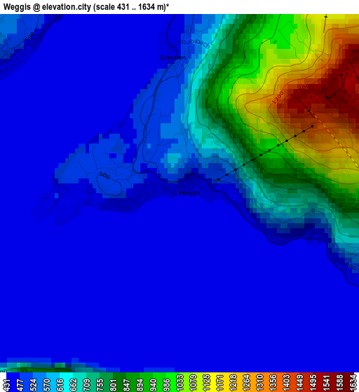
Below is the Elevation map of Weggis, which displays elevation range with different colors. Scale of the first map is from 431 to 1634 m (1414 to 5361 ft) with average elevation of 589.9 meters (=1935 ft) [note 1]
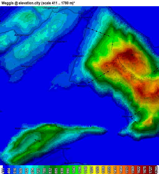
These maps also provides idea of topography and contour of this city, they are displayed at different zoom levels. More info about maps, scale and edge coordinates you can find below images.
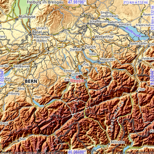
| \ | Map #1 | Map #2 | Topo.Map |
| Scale [m] | 431..1634 m | 411..1780 m | × |
| Scale [ft] | 1414..5361 ft | 1348..5840 ft | × |
| Average | 589.9 m = 1935 ft | 630.4 m = 2068 ft | × |
| Width | 6.66 km = 4.1 mi | 13.32 km = 8.3 mi | 213.1 km = 132.4 mi |
| Height | 6.66 km = 4.1 mi | 13.32 km = 8.3 mi | 213.1 km = 132.4 mi |
| ↑Max Latitude | 47.062024° | 47.091952° | 47.98196° |
| Latitude at center | 47.03208° | 47.03208° | 47.03208° |
| ↓Min Latitude | 47.002119° | 46.972141° | 46.06498° |
| ← Min Longitude | 8.388245° | 8.344299° | 7.02594° |
| Longitude center | 8.43219° | 8.43219° | 8.43219° |
| →Max Longitude | 8.476135° | 8.520081° | 9.83844° |
Nearby cities:
Cities around Weggis sort by population:
• Küssnacht elevation 440 m
6 km,  7°
7°
• Ebikon 437 m
8.7 km,  307°
307°
• Arth 425 m
7.7 km,  63°
63°
• Meggen 476 m
4.7 km,  290°
290°
• Adligenswil 547 m
6.5 km,  304°
304°
• Buochs 441 m
6.5 km,  186°
186°
• Goldau 517 m
8.8 km,  78°
78°
• Ennetbürgen 436 m
5.6 km,  197°
197°
• Beckenried 434 m
8 km,  155°
155°
• Udligenswil 621 m
6.8 km,  341°
341°
• Gersau 465 m
8.2 km,  120°
120°
• Vitznau 448 m
4.6 km, 121°
Multilingual:
 En español:
Weggis elevación 439 m.
 En France:
Weggis élévation 439 m.


Sources and notes:
- [note 1] Map square and city borders are not equal. Map elevation data is calculated only from area inside that square.
- [src 1] Elevation data from geonames database provided with same terms of usage.
- [src 2] The elevation map of Weggis is generated using elevation data from NASA's 3 arcsec (90m) resolution SRTM data.
- [src 3] Base (background) map © OpenStreetMap contributors tiles are generated by Geofabrik and OpenTopoMap.
Copyright & License:
This Weggis Elevation Map is licensed under CC BY-SA. You may reuse any part from this page, if you give a proper credit by linking to this URL:
 More info on terms of use page.