La Tour-de-Trême elevation
La Tour-de-Trême (Fribourg, Gruyère District), Switzerland elevation is 747 meters and La Tour-de-Trême elevation in feet is 2451 ft above sea level [src 1]. La Tour-de-Trême is a populated place (feature code) with elevation that is 199 meters (653 ft) bigger than average city elevation in Switzerland.
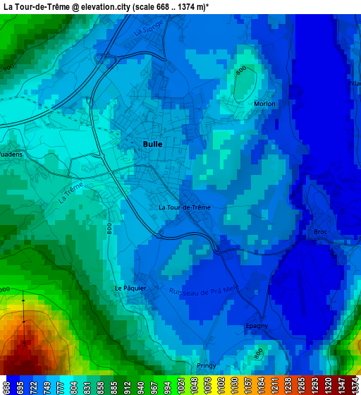
Below is the Elevation map of La Tour-de-Trême, which displays elevation range with different colors. Scale of the first map is from 668 to 1374 m (2192 to 4508 ft) with average elevation of 786.5 meters (=2580 ft) [note 1]
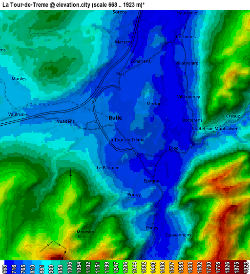
These maps also provides idea of topography and contour of this city, they are displayed at different zoom levels. More info about maps, scale and edge coordinates you can find below images.
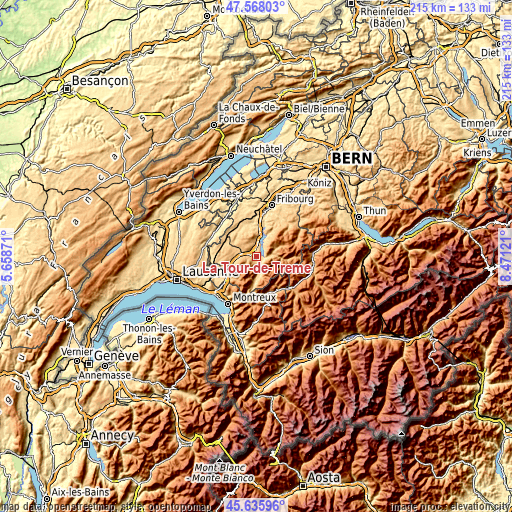
| \ | Map #1 | Map #2 | Topo.Map |
| Scale [m] | 668..1374 m | 668..1923 m | × |
| Scale [ft] | 2192..4508 ft | 2192..6309 ft | × |
| Average | 786.5 m = 2580 ft | 972.9 m = 3192 ft | × |
| Width | 6.71 km = 4.2 mi | 13.43 km = 8.3 mi | 214.8 km = 133.5 mi |
| Height | 6.71 km = 4.2 mi | 13.43 km = 8.3 mi | 214.8 km = 133.5 mi |
| ↑Max Latitude | 46.64079° | 46.670953° | 47.56803° |
| Latitude at center | 46.61061° | 46.61061° | 46.61061° |
| ↓Min Latitude | 46.580413° | 46.5502° | 45.63596° |
| ← Min Longitude | 7.021015° | 6.977069° | 5.65871° |
| Longitude center | 7.06496° | 7.06496° | 7.06496° |
| →Max Longitude | 7.108905° | 7.152851° | 8.47121° |
Nearby cities:
Cities around La Tour-de-Trême sort by population:
• Bulle elevation 771 m
1 km,  323°
323°
• Broc 719 m
2.7 km,  103°
103°
• Riaz 729 m
3.5 km,  356°
356°
• Vuadens 816 m
3.7 km,  278°
278°
• Charmey 895 m
7.7 km,  82°
82°
• Gruyères 805 m
3.3 km,  156°
156°
• Marsens 759 m
5.1 km, 355°
• La Roche 750 m
11 km,  30°
30°
• Sâles 826 m
7.5 km,  290°
290°
• Mézières 769 m
13.1 km,  305°
305°
• Vuisternens-devant-Romont 801 m
11.4 km, 294°
• Pont-la-Ville 788 m
10.3 km,  19°
19°
Multilingual:
 En español:
La Tour-de-Trême elevación 747 m.
 En France:
La Tour-de-Trême élévation 747 m.
 Auf Deutsch:
La Tour-de-Trême höhe über dem Meeresspiegel ist 747 m.

Sources and notes:
- [note 1] Map square and city borders are not equal. Map elevation data is calculated only from area inside that square.
- [src 1] Elevation data from geonames database provided with same terms of usage.
- [src 2] The elevation map of La Tour-de-Trême is generated using elevation data from NASA's 3 arcsec (90m) resolution SRTM data.
- [src 3] Base (background) map © OpenStreetMap contributors tiles are generated by Geofabrik and OpenTopoMap.
Copyright & License:
This La Tour-de-Trême Elevation Map is licensed under CC BY-SA. You may reuse any part from this page, if you give a proper credit by linking to this URL:
 More info on terms of use page.