Meilen elevation
Meilen (Zurich, Bezirk Meilen), Switzerland elevation is 464 meters and Meilen elevation in feet is 1522 ft above sea level [src 1]. Meilen is a seat of a second-order administrative division (feature code) with elevation that is 84 meters (276 ft) smaller than average city elevation in Switzerland.
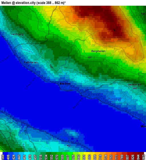
Below is the Elevation map of Meilen, which displays elevation range with different colors. Scale of the first map is from 388 to 862 m (1273 to 2828 ft) with average elevation of 512.3 meters (=1681 ft) [note 1]
These maps also provides idea of topography and contour of this city, they are displayed at different zoom levels. More info about maps, scale and edge coordinates you can find below images.
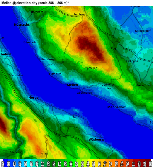
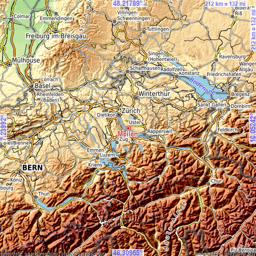
| \ | Map #1 | Map #2 | Topo.Map |
| Scale [m] | 388..862 m | 388..866 m | × |
| Scale [ft] | 1273..2828 ft | 1273..2841 ft | × |
| Average | 512.3 m = 1681 ft | 526.1 m = 1726 ft | × |
| Width | 6.63 km = 4.1 mi | 13.26 km = 8.2 mi | 212.2 km = 131.9 mi |
| Height | 6.63 km = 4.1 mi | 13.26 km = 8.2 mi | 212.2 km = 131.9 mi |
| ↑Max Latitude | 47.302129° | 47.331921° | 48.21789° |
| Latitude at center | 47.27232° | 47.27232° | 47.27232° |
| ↓Min Latitude | 47.242494° | 47.212651° | 46.30955° |
| ← Min Longitude | 8.602225° | 8.558279° | 7.23992° |
| Longitude center | 8.64617° | 8.64617° | 8.64617° |
| →Max Longitude | 8.690115° | 8.734061° | 10.05242° |
Nearby cities:
Cities around Meilen sort by population:
• Horgen elevation 419 m
3.9 km,  249°
249°
• Horgen / Horgen (Dorfkern) 449 m
3.8 km,  241°
241°
• Herrliberg 519 m
3.1 km,  310°
310°
• Männedorf / Dorfkern 425 m
3.9 km,  117°
117°
• Au 478 m
3.4 km,  182°
182°
• Horgen / Allmend 515 m
4.1 km,  227°
227°
• Feldmeilen 444 m
2 km,  291°
291°
• Uetikon 451 m
2.6 km,  109°
109°
• Obermeilen 419 m
1 km,  135°
135°
• Au / Mittel-Dorf 460 m
3.3 km, 180°
• Au / Unter-Dorf 442 m
3 km,  200°
200°
• Uetikon / Grossdorf 458 m
2.5 km, 105°
Multilingual:
 En español:
Meilen elevación 464 m.
 En France:
Meilen élévation 464 m.


Sources and notes:
- [note 1] Map square and city borders are not equal. Map elevation data is calculated only from area inside that square.
- [src 1] Elevation data from geonames database provided with same terms of usage.
- [src 2] The elevation map of Meilen is generated using elevation data from NASA's 3 arcsec (90m) resolution SRTM data.
- [src 3] Base (background) map © OpenStreetMap contributors tiles are generated by Geofabrik and OpenTopoMap.
Copyright & License:
This Meilen Elevation Map is licensed under CC BY-SA. You may reuse any part from this page, if you give a proper credit by linking to this URL:
 More info on terms of use page.