Meyrin elevation
Meyrin (Geneva), Switzerland elevation is 445 meters and Meyrin elevation in feet is 1460 ft above sea level [src 1]. Meyrin is a populated place (feature code) with elevation that is 103 meters (338 ft) smaller than average city elevation in Switzerland.
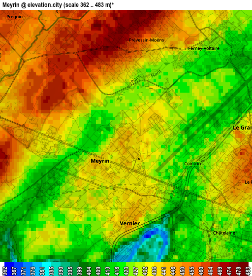
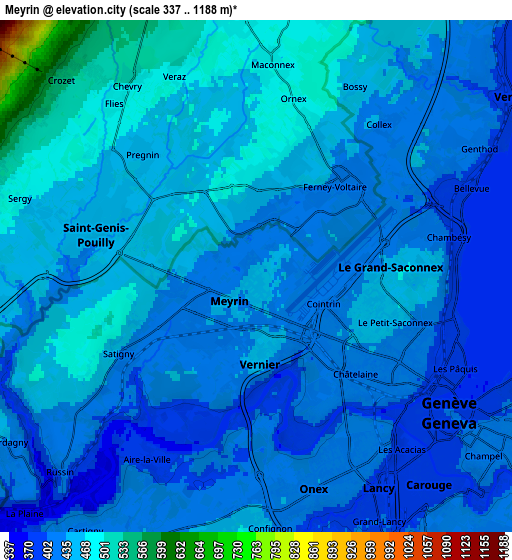
Below is the Elevation map of Meyrin, which displays elevation range with different colors. Scale of the first map is from 362 to 483 m (1188 to 1585 ft) with average elevation of 433.4 meters (=1422 ft) [note 1]
These maps also provides idea of topography and contour of this city, they are displayed at different zoom levels. More info about maps, scale and edge coordinates you can find below images.
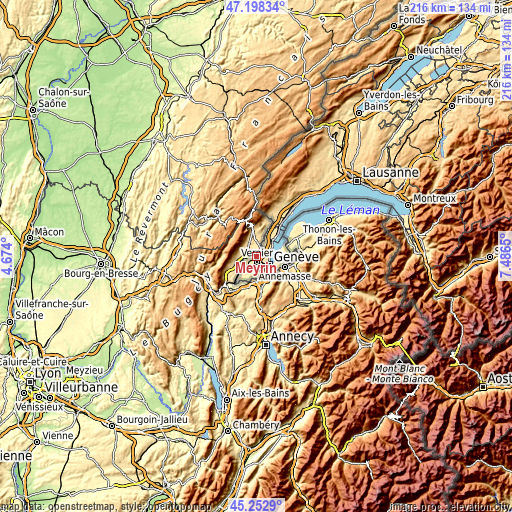
| \ | Map #1 | Map #2 | Topo.Map |
| Scale [m] | 362..483 m | 337..1188 m | × |
| Scale [ft] | 1188..1585 ft | 1106..3898 ft | × |
| Average | 433.4 m = 1422 ft | 438.5 m = 1439 ft | × |
| Width | 6.76 km = 4.2 mi | 13.52 km = 8.4 mi | 216.3 km = 134.4 mi |
| Height | 6.76 km = 4.2 mi | 13.52 km = 8.4 mi | 216.3 km = 134.4 mi |
| ↑Max Latitude | 46.264629° | 46.295001° | 47.19834° |
| Latitude at center | 46.23424° | 46.23424° | 46.23424° |
| ↓Min Latitude | 46.203834° | 46.173411° | 45.2529° |
| ← Min Longitude | 6.036305° | 5.992359° | 4.674° |
| Longitude center | 6.08025° | 6.08025° | 6.08025° |
| →Max Longitude | 6.124195° | 6.168141° | 7.4865° |
Nearby cities:
Cities around Meyrin sort by population:
• Genève elevation 400 m
6.2 km,  125°
125°
• Vernier 440 m
1.9 km,  169°
169°
• Lancy 421 m
5.6 km,  151°
151°
• Carouge 388 m
7.5 km,  142°
142°
• Onex 426 m
5.8 km,  163°
163°
• Le Grand-Saconnex 450 m
3.1 km,  94°
94°
• Bernex 451 m
6.4 km,  183°
183°
• Les Avanchets 430 m
2.6 km,  123°
123°
• Bellevue 384 m
6.3 km,  65°
65°
• Confignon 438 m
6.8 km, 177°
• Satigny 422 m
4.1 km,  237°
237°
• Aire-la-Ville 377 m
5.6 km,  210°
210°
Multilingual:
 En español:
Meyrin elevación 445 m.
 En France:
Meyrin élévation 445 m.


Sources and notes:
- [note 1] Map square and city borders are not equal. Map elevation data is calculated only from area inside that square.
- [src 1] Elevation data from geonames database provided with same terms of usage.
- [src 2] The elevation map of Meyrin is generated using elevation data from NASA's 3 arcsec (90m) resolution SRTM data.
- [src 3] Base (background) map © OpenStreetMap contributors tiles are generated by Geofabrik and OpenTopoMap.
Copyright & License:
This Meyrin Elevation Map is licensed under CC BY-SA. You may reuse any part from this page, if you give a proper credit by linking to this URL:
 More info on terms of use page.