Muri elevation
Muri (Bern, Bern-Mittelland District), Switzerland elevation is 558 meters and Muri elevation in feet is 1831 ft above sea level [src 1]. Muri is a populated place (feature code) with elevation that is 10 meters (33 ft) bigger than average city elevation in Switzerland.
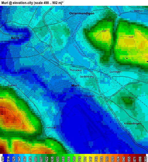
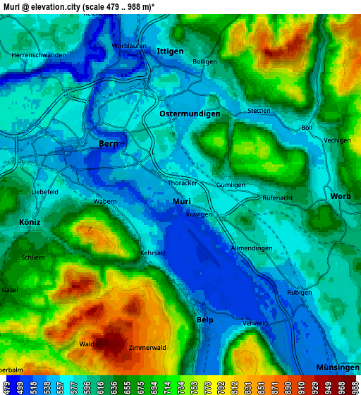
Below is the Elevation map of Muri, which displays elevation range with different colors. Scale of the first map is from 498 to 902 m (1634 to 2959 ft) with average elevation of 585.6 meters (=1921 ft) [note 1]
These maps also provides idea of topography and contour of this city, they are displayed at different zoom levels. More info about maps, scale and edge coordinates you can find below images.
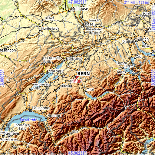
| \ | Map #1 | Map #2 | Topo.Map |
| Scale [m] | 498..902 m | 479..988 m | × |
| Scale [ft] | 1634..2959 ft | 1572..3241 ft | × |
| Average | 585.6 m = 1921 ft | 630.4 m = 2068 ft | × |
| Width | 6.67 km = 4.1 mi | 13.35 km = 8.3 mi | 213.6 km = 132.7 mi |
| Height | 6.67 km = 4.1 mi | 13.35 km = 8.3 mi | 213.5 km = 132.7 mi |
| ↑Max Latitude | 46.961221° | 46.991205° | 47.88291° |
| Latitude at center | 46.93122° | 46.93122° | 46.93122° |
| ↓Min Latitude | 46.901202° | 46.871168° | 45.96231° |
| ← Min Longitude | 7.442635° | 7.398689° | 6.08033° |
| Longitude center | 7.48658° | 7.48658° | 7.48658° |
| →Max Longitude | 7.530525° | 7.574471° | 8.89283° |
Nearby cities:
Cities around Muri sort by population:
• Bern elevation 549 m
3.5 km,  302°
302°
• Köniz 577 m
5.5 km,  262°
262°
• Worb 585 m
5.8 km,  91°
91°
• Belp 519 m
4.5 km,  168°
168°
• Zollikofen 558 m
7.8 km,  344°
344°
• Bolligen 582 m
4.9 km,  9°
9°
• Vechigen 605 m
5.9 km,  73°
73°
• Kehrsatz 572 m
2.6 km,  207°
207°
• Stettlen 563 m
4.2 km,  44°
44°
• Rubigen 549 m
5.7 km,  129°
129°
• Toffen 531 m
7.9 km,  176°
176°
• Ostermundigen 550 m
2.9 km, 5°
Multilingual:
 En español:
Muri bei Bern elevación 558 m.
 En France:
Muri bei Bern élévation 558 m.
 Auf Deutsch:
Muri bei Bern, Muri b. Bern höhe über dem Meeresspiegel ist 558 m.

Sources and notes:
- [note 1] Map square and city borders are not equal. Map elevation data is calculated only from area inside that square.
- [src 1] Elevation data from geonames database provided with same terms of usage.
- [src 2] The elevation map of Muri is generated using elevation data from NASA's 3 arcsec (90m) resolution SRTM data.
- [src 3] Base (background) map © OpenStreetMap contributors tiles are generated by Geofabrik and OpenTopoMap.
Copyright & License:
This Muri Elevation Map is licensed under CC BY-SA. You may reuse any part from this page, if you give a proper credit by linking to this URL:
 More info on terms of use page.