Neunkirch elevation
Neunkirch (Schaffhausen, Bezirk Oberklettgau), Switzerland elevation is 430 meters and Neunkirch elevation in feet is 1411 ft above sea level [src 1]. Neunkirch is a seat of a second-order administrative division (feature code) with elevation that is 118 meters (387 ft) smaller than average city elevation in Switzerland.
Below is the Elevation map of Neunkirch, which displays elevation range with different colors. Scale of the first map is from 389 to 794 m (1276 to 2605 ft) with average elevation of 491.7 meters (=1613 ft) [note 1]
These maps also provides idea of topography and contour of this city, they are displayed at different zoom levels. More info about maps, scale and edge coordinates you can find below images.
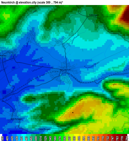
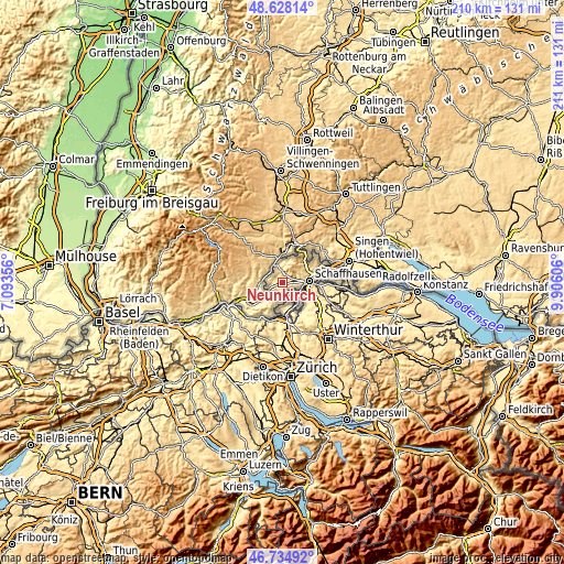
| \ | Map #1 | Topo.Map |
| Scale [m] | 389..794 m | × |
| Scale [ft] | 1276..2605 ft | × |
| Average | 491.7 m = 1613 ft | × |
| Width | 6.58 km = 4.1 mi | 210.5 km = 130.8 mi |
| Height | 6.58 km = 4.1 mi | 210.5 km = 130.8 mi |
| ↑Max Latitude | 47.719693° | 48.62814° |
| Latitude at center | 47.69012° | 47.69012° |
| ↓Min Latitude | 47.66053° | 46.73492° |
| ← Min Longitude | 8.455865° | 7.09356° |
| Longitude center | 8.49981° | 8.49981° |
| →Max Longitude | 8.543755° | 9.90606° |
Nearby cities:
Cities around Neunkirch sort by population:
• Schaffhausen elevation 403 m
10.1 km,  85°
85°
• Neuhausen 471 m
8.6 km, 93°
• Rafz 421 m
10.1 km,  161°
161°
• Beringen 454 m
5.6 km,  81°
81°
• Wilchingen 426 m
3.5 km,  223°
223°
• Feuerthalen 418 m
10.8 km, 89°
• Hallau 424 m
3.2 km,  282°
282°
• Schleitheim 470 m
6.6 km,  348°
348°
• Dachsen 392 m
9.3 km,  107°
107°
• Flurlingen 406 m
9.8 km, 94°
• Uhwiesen 468 m
10.4 km,  101°
101°
• Löhningen 478 m
4.1 km,  72°
72°
Multilingual:
 En español:
Neunkirch elevación 430 m.
 En France:
Neunkirch élévation 430 m.
 Auf Deutsch:
Neunkirch höhe über dem Meeresspiegel ist 430 m.

Sources and notes:
- [note 1] Map square and city borders are not equal. Map elevation data is calculated only from area inside that square.
- [src 1] Elevation data from geonames database provided with same terms of usage.
- [src 2] The elevation map of Neunkirch is generated using elevation data from NASA's 3 arcsec (90m) resolution SRTM data.
- [src 3] Base (background) map © OpenStreetMap contributors tiles are generated by Geofabrik and OpenTopoMap.
Copyright & License:
This Neunkirch Elevation Map is licensed under CC BY-SA. You may reuse any part from this page, if you give a proper credit by linking to this URL:
 More info on terms of use page.