Schaffhausen elevation
Schaffhausen, Switzerland elevation is 403 meters and Schaffhausen elevation in feet is 1322 ft above sea level [src 1]. Schaffhausen is a seat of a first-order administrative division (feature code) with elevation that is 145 meters (476 ft) smaller than average city elevation in Switzerland.
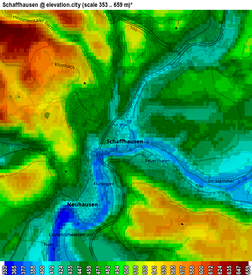
Below is the Elevation map of Schaffhausen, which displays elevation range with different colors. Scale of the first map is from 353 to 659 m (1158 to 2162 ft) with average elevation of 479.8 meters (=1574 ft) [note 1]
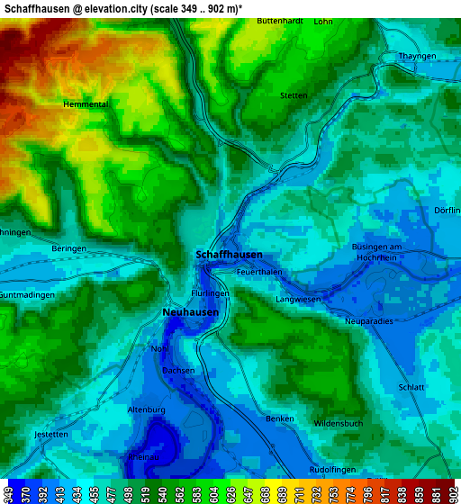
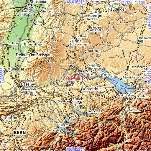
These maps also provides idea of topography and contour of this city, they are displayed at different zoom levels. More info about maps, scale and edge coordinates you can find below images.
| \ | Map #1 | Map #2 | Topo.Map |
| Scale [m] | 353..659 m | 349..902 m | × |
| Scale [ft] | 1158..2162 ft | 1145..2959 ft | × |
| Average | 479.8 m = 1574 ft | 505.7 m = 1659 ft | × |
| Width | 6.58 km = 4.1 mi | 13.15 km = 8.2 mi | 210.5 km = 130.8 mi |
| Height | 6.58 km = 4.1 mi | 13.15 km = 8.2 mi | 210.5 km = 130.8 mi |
| ↑Max Latitude | 47.726889° | 47.756441° | 48.63521° |
| Latitude at center | 47.69732° | 47.69732° | 47.69732° |
| ↓Min Latitude | 47.667734° | 47.638132° | 46.74225° |
| ← Min Longitude | 8.590985° | 8.547039° | 7.22868° |
| Longitude center | 8.63493° | 8.63493° | 8.63493° |
| →Max Longitude | 8.678875° | 8.722821° | 10.04118° |
Nearby cities:
Cities around Schaffhausen sort by population:
• Neuhausen elevation 471 m
2 km,  229°
229°
• Thayngen 436 m
7.7 km,  44°
44°
• Beringen 454 m
4.5 km,  270°
270°
• Feuerthalen 418 m
1 km,  139°
139°
• Neunkirch 430 m
10.1 km, 265°
• Marthalen 395 m
7.7 km,  169°
169°
• Dachsen 392 m
3.8 km,  199°
199°
• Flurlingen 406 m
1.5 km,  194°
194°
• Uhwiesen 468 m
3 km,  179°
179°
• Löhningen 478 m
6.2 km, 274°
• Stetten 573 m
5.2 km,  23°
23°
• Diessenhofen 406 m
8.6 km,  96°
96°
Multilingual:
 En español:
Schaffhausen elevación 403 m.
 En France:
Schaffhouse élévation 403 m.
 Auf Deutsch:
Schaffhausen höhe über dem Meeresspiegel ist 403 m.

Sources and notes:
- [note 1] Map square and city borders are not equal. Map elevation data is calculated only from area inside that square.
- [src 1] Elevation data from geonames database provided with same terms of usage.
- [src 2] The elevation map of Schaffhausen is generated using elevation data from NASA's 3 arcsec (90m) resolution SRTM data.
- [src 3] Base (background) map © OpenStreetMap contributors tiles are generated by Geofabrik and OpenTopoMap.
Copyright & License:
This Schaffhausen Elevation Map is licensed under CC BY-SA. You may reuse any part from this page, if you give a proper credit by linking to this URL:
 More info on terms of use page.