La Punt Chamues-ch elevation
La Punt Chamues-ch (Grisons, Region Maloja), Switzerland elevation is 1729 meters and La Punt Chamues-ch elevation in feet is 5673 ft above sea level [src 1]. La Punt Chamues-ch is a seat of a third-order administrative division (feature code) with elevation that is 1181 meters (3875 ft) bigger than average city elevation in Switzerland.
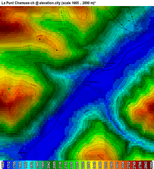
Below is the Elevation map of La Punt Chamues-ch, which displays elevation range with different colors. Scale of the first map is from 1665 to 2890 m (5463 to 9482 ft) with average elevation of 2087.3 meters (=6848 ft) [note 1]
These maps also provides idea of topography and contour of this city, they are displayed at different zoom levels. More info about maps, scale and edge coordinates you can find below images.
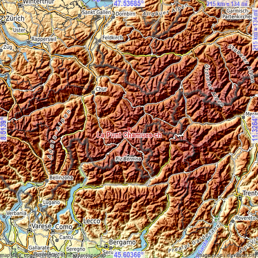
| \ | Map #1 | Topo.Map |
| Scale [m] | 1665..2890 m | × |
| Scale [ft] | 5463..9482 ft | × |
| Average | 2087.3 m = 6848 ft | × |
| Width | 6.72 km = 4.2 mi | 215 km = 133.6 mi |
| Height | 6.72 km = 4.2 mi | 214.9 km = 133.5 mi |
| ↑Max Latitude | 46.609068° | 47.53685° |
| Latitude at center | 46.57887° | 46.57887° |
| ↓Min Latitude | 46.548656° | 45.60366° |
| ← Min Longitude | 9.876205° | 8.5139° |
| Longitude center | 9.92015° | 9.92015° |
| →Max Longitude | 9.964095° | 11.3264° |
Nearby cities:
Cities around La Punt Chamues-ch sort by population:
• Davos elevation 1560 m
25.8 km,  345°
345°
• St. Moritz 1845 m
10.6 km,  213°
213°
• Poschiavo 1010 m
30.2 km,  159°
159°
• Samedan 1716 m
6.2 km,  215°
215°
• Lenzerheide 1471 m
31.8 km,  300°
300°
• Arosa 1801 m
28.9 km,  319°
319°
• Pontresina 1822 m
9.4 km,  188°
188°
• Celerina 1727 m
8.8 km, 212°
• Zuoz 1718 m
4 km,  49°
49°
• Zernez 1477 m
18.7 km,  44°
44°
• Silvaplana 1817 m
16.5 km, 215°
• Tiefencastel 891 m
27.6 km,  289°
289°
Multilingual:
 En español:
La Punt Chamues-ch elevación 1729 m.
 En France:
La Punt Chamues-ch élévation 1729 m.
 Auf Deutsch:
La Punt höhe über dem Meeresspiegel ist 1729 m.
 На русском:
La Punt Chamues-ch высота над уровнем моря 1729 м
Sources and notes:
- [note 1] Map square and city borders are not equal. Map elevation data is calculated only from area inside that square.
- [src 1] Elevation data from geonames database provided with same terms of usage.
- [src 2] The elevation map of La Punt Chamues-ch is generated using elevation data from NASA's 3 arcsec (90m) resolution SRTM data.
- [src 3] Base (background) map © OpenStreetMap contributors tiles are generated by Geofabrik and OpenTopoMap.
Copyright & License:
This La Punt Chamues-ch Elevation Map is licensed under CC BY-SA. You may reuse any part from this page, if you give a proper credit by linking to this URL:
 More info on terms of use page.