Zernez elevation
Zernez (Grisons, Region Engiadina Bassa / Val Müstair), Switzerland elevation is 1477 meters and Zernez elevation in feet is 4846 ft above sea level [src 1]. Zernez is a populated place (feature code) with elevation that is 929 meters (3048 ft) bigger than average city elevation in Switzerland.
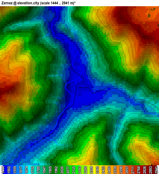
Below is the Elevation map of Zernez, which displays elevation range with different colors. Scale of the first map is from 1444 to 2941 m (4738 to 9649 ft) with average elevation of 1984.2 meters (=6510 ft) [note 1]
These maps also provides idea of topography and contour of this city, they are displayed at different zoom levels. More info about maps, scale and edge coordinates you can find below images.
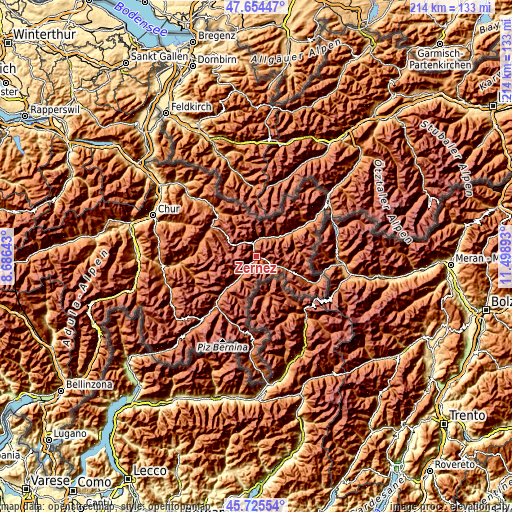
| \ | Map #1 | Topo.Map |
| Scale [m] | 1444..2941 m | × |
| Scale [ft] | 4738..9649 ft | × |
| Average | 1984.2 m = 6510 ft | × |
| Width | 6.7 km = 4.2 mi | 214.5 km = 133.3 mi |
| Height | 6.7 km = 4.2 mi | 214.5 km = 133.3 mi |
| ↑Max Latitude | 46.728751° | 47.65447° |
| Latitude at center | 46.69862° | 46.69862° |
| ↓Min Latitude | 46.668472° | 45.72554° |
| ← Min Longitude | 10.048735° | 8.68643° |
| Longitude center | 10.09268° | 10.09268° |
| →Max Longitude | 10.136625° | 11.49893° |
Nearby cities:
Cities around Zernez sort by population:
• Davos elevation 1560 m
22.7 km,  301°
301°
• St. Moritz 1845 m
29.2 km,  220°
220°
• Klosters Serneus 998 m
28.7 km,  317°
317°
• Samedan 1716 m
24.8 km, 222°
• Arosa 1801 m
32.9 km,  285°
285°
• Scuol 1224 m
19.1 km,  55°
55°
• Pontresina 1822 m
26.9 km,  212°
212°
• Celerina 1727 m
27.4 km, 220°
• Zuoz 1718 m
14.8 km, 223°
• Luzein 950 m
35.2 km,  314°
314°
• Silvaplana 1817 m
35.1 km, 220°
• La Punt Chamues-ch 1729 m
18.7 km, 224°
Multilingual:
 En español:
Zernez elevación 1477 m.
 En France:
Zernez élévation 1477 m.


Sources and notes:
- [note 1] Map square and city borders are not equal. Map elevation data is calculated only from area inside that square.
- [src 1] Elevation data from geonames database provided with same terms of usage.
- [src 2] The elevation map of Zernez is generated using elevation data from NASA's 3 arcsec (90m) resolution SRTM data.
- [src 3] Base (background) map © OpenStreetMap contributors tiles are generated by Geofabrik and OpenTopoMap.
Copyright & License:
This Zernez Elevation Map is licensed under CC BY-SA. You may reuse any part from this page, if you give a proper credit by linking to this URL:
 More info on terms of use page.