Safenwil elevation
Safenwil (Aargau, Bezirk Zofingen), Switzerland elevation is 475 meters and Safenwil elevation in feet is 1558 ft above sea level [src 1]. Safenwil is a populated place (feature code) with elevation that is 73 meters (240 ft) smaller than average city elevation in Switzerland.
Below is the Elevation map of Safenwil, which displays elevation range with different colors. Scale of the first map is from 377 to 709 m (1237 to 2326 ft) with average elevation of 507.8 meters (=1666 ft) [note 1]
These maps also provides idea of topography and contour of this city, they are displayed at different zoom levels. More info about maps, scale and edge coordinates you can find below images.
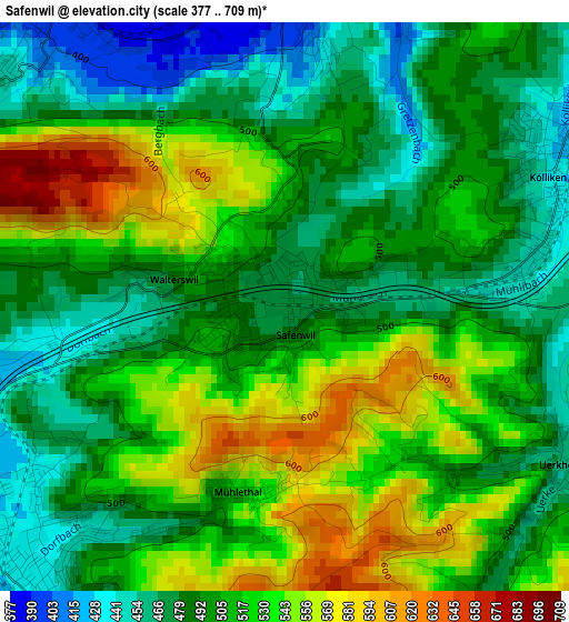
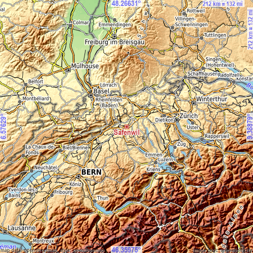
| \ | Map #1 | Topo.Map |
| Scale [m] | 377..709 m | × |
| Scale [ft] | 1237..2326 ft | × |
| Average | 507.8 m = 1666 ft | × |
| Width | 6.62 km = 4.1 mi | 212 km = 131.7 mi |
| Height | 6.62 km = 4.1 mi | 212 km = 131.7 mi |
| ↑Max Latitude | 47.351411° | 48.26631° |
| Latitude at center | 47.32163° | 47.32163° |
| ↓Min Latitude | 47.291832° | 46.35975° |
| ← Min Longitude | 7.938595° | 6.57629° |
| Longitude center | 7.98254° | 7.98254° |
| →Max Longitude | 8.026485° | 9.38879° |
Nearby cities:
Cities around Safenwil sort by population:
• Zofingen elevation 441 m
4.7 km,  216°
216°
• Oftringen 416 m
4.4 km,  258°
258°
• Oberentfelden 413 m
6.1 km,  51°
51°
• Schönenwerd 388 m
5.5 km,  15°
15°
• Strengelbach 433 m
6.2 km, 220°
• Kölliken 426 m
3.3 km,  66°
66°
• Niedergösgen 379 m
5.6 km,  4°
4°
• Muhen 430 m
5.7 km, 74°
• Schöftland 462 m
5.5 km,  108°
108°
• Obergösgen 392 m
5.4 km,  334°
334°
• Uerkheim 455 m
3.7 km,  123°
123°
• Staffelbach 486 m
6.1 km,  133°
133°
Multilingual:
 En español:
Safenwil elevación 475 m.
 En France:
Safenwil élévation 475 m.
 Auf Deutsch:
Safenwil höhe über dem Meeresspiegel ist 475 m.

Sources and notes:
- [note 1] Map square and city borders are not equal. Map elevation data is calculated only from area inside that square.
- [src 1] Elevation data from geonames database provided with same terms of usage.
- [src 2] The elevation map of Safenwil is generated using elevation data from NASA's 3 arcsec (90m) resolution SRTM data.
- [src 3] Base (background) map © OpenStreetMap contributors tiles are generated by Geofabrik and OpenTopoMap.
Copyright & License:
This Safenwil Elevation Map is licensed under CC BY-SA. You may reuse any part from this page, if you give a proper credit by linking to this URL:
 More info on terms of use page.