Saint-Prex elevation
Saint-Prex (Vaud, Morges District), Switzerland elevation is 379 meters and Saint-Prex elevation in feet is 1243 ft above sea level [src 1]. Saint-Prex is a populated place (feature code) with elevation that is 169 meters (554 ft) smaller than average city elevation in Switzerland.
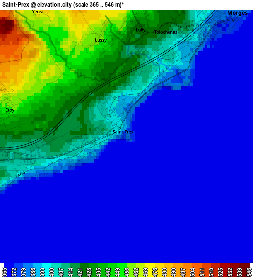
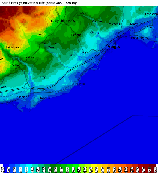
Below is the Elevation map of Saint-Prex, which displays elevation range with different colors. Scale of the first map is from 365 to 546 m (1198 to 1791 ft) with average elevation of 395.3 meters (=1297 ft) [note 1]
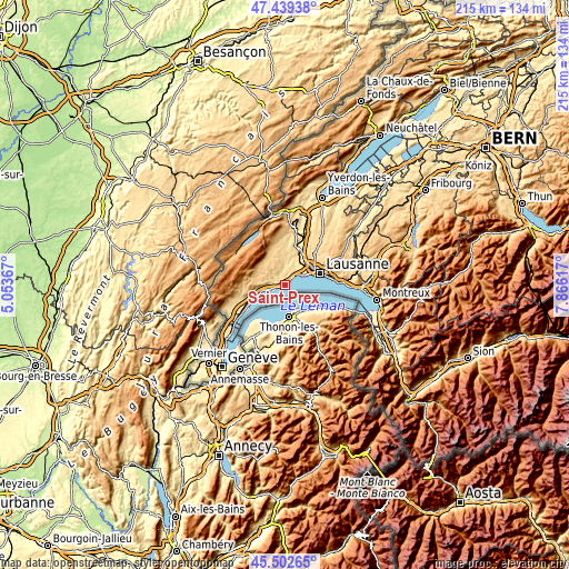
These maps also provides idea of topography and contour of this city, they are displayed at different zoom levels. More info about maps, scale and edge coordinates you can find below images.
| \ | Map #1 | Map #2 | Topo.Map |
| Scale [m] | 365..546 m | 365..735 m | × |
| Scale [ft] | 1198..1791 ft | 1198..2411 ft | × |
| Average | 395.3 m = 1297 ft | 420.5 m = 1380 ft | × |
| Width | 6.73 km = 4.2 mi | 13.46 km = 8.4 mi | 215.3 km = 133.8 mi |
| Height | 6.73 km = 4.2 mi | 13.46 km = 8.4 mi | 215.3 km = 133.8 mi |
| ↑Max Latitude | 46.509883° | 46.540119° | 47.43938° |
| Latitude at center | 46.47963° | 46.47963° | 46.47963° |
| ↓Min Latitude | 46.44936° | 46.419074° | 45.50265° |
| ← Min Longitude | 6.415975° | 6.372029° | 5.05367° |
| Longitude center | 6.45992° | 6.45992° | 6.45992° |
| →Max Longitude | 6.503865° | 6.547811° | 7.86617° |
Nearby cities:
Cities around Saint-Prex sort by population:
• Morges elevation 380 m
4.6 km,  40°
40°
• Ecublens 419 m
9.6 km,  55°
55°
• Colombier 531 m
8.7 km,  6°
6°
• Chavannes 399 m
10.2 km, 56°
• Préverenges 407 m
6.7 km,  49°
49°
• Rolle 389 m
9.9 km,  256°
256°
• Aubonne 512 m
5.5 km,  288°
288°
• Perroy 413 m
8.3 km, 260°
• Apples 630 m
8.4 km,  343°
343°
• Saint-Livres 610 m
6.4 km,  299°
299°
• Ballens 704 m
10.7 km,  321°
321°
• Saubraz 687 m
10.7 km, 292°
Multilingual:
 En español:
Saint-Prex elevación 379 m.
 En France:
Saint-Prex élévation 379 m.
 Auf Deutsch:
Saint-Prex höhe über dem Meeresspiegel ist 379 m.

Sources and notes:
- [note 1] Map square and city borders are not equal. Map elevation data is calculated only from area inside that square.
- [src 1] Elevation data from geonames database provided with same terms of usage.
- [src 2] The elevation map of Saint-Prex is generated using elevation data from NASA's 3 arcsec (90m) resolution SRTM data.
- [src 3] Base (background) map © OpenStreetMap contributors tiles are generated by Geofabrik and OpenTopoMap.
Copyright & License:
This Saint-Prex Elevation Map is licensed under CC BY-SA. You may reuse any part from this page, if you give a proper credit by linking to this URL:
 More info on terms of use page.