Seengen elevation
Seengen (Aargau, Bezirk Lenzburg), Switzerland elevation is 474 meters and Seengen elevation in feet is 1555 ft above sea level [src 1]. Seengen is a populated place (feature code) with elevation that is 74 meters (243 ft) smaller than average city elevation in Switzerland.
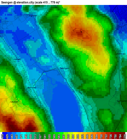
Below is the Elevation map of Seengen, which displays elevation range with different colors. Scale of the first map is from 415 to 778 m (1362 to 2552 ft) with average elevation of 531.6 meters (=1744 ft) [note 1]
These maps also provides idea of topography and contour of this city, they are displayed at different zoom levels. More info about maps, scale and edge coordinates you can find below images.
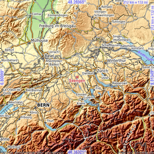
| \ | Map #1 | Topo.Map |
| Scale [m] | 415..778 m | × |
| Scale [ft] | 1362..2552 ft | × |
| Average | 531.6 m = 1744 ft | × |
| Width | 6.62 km = 4.1 mi | 212 km = 131.7 mi |
| Height | 6.62 km = 4.1 mi | 212 km = 131.7 mi |
| ↑Max Latitude | 47.354809° | 48.26965° |
| Latitude at center | 47.32503° | 47.32503° |
| ↓Min Latitude | 47.295234° | 46.36321° |
| ← Min Longitude | 8.163295° | 6.80099° |
| Longitude center | 8.20724° | 8.20724° |
| →Max Longitude | 8.251185° | 9.61349° |
Nearby cities:
Cities around Seengen sort by population:
• Wohlen elevation 418 m
5.9 km,  60°
60°
• Villmergen 422 m
4.1 km,  47°
47°
• Seon 438 m
4.4 km,  306°
306°
• Dottikon 416 m
7 km,  20°
20°
• Meisterschwanden 503 m
3.7 km,  154°
154°
• Sarmenstorf 535 m
3.5 km,  115°
115°
• Waltenschwil 431 m
6.9 km,  82°
82°
• Teufenthal 453 m
6.8 km,  273°
273°
• Boniswil 464 m
1.6 km,  236°
236°
• Egliswil 453 m
3.1 km,  328°
328°
• Dürrenäsch 580 m
3.7 km,  262°
262°
• Oberkulm 489 m
7 km,  245°
245°
Multilingual:
 En español:
Seengen elevación 474 m.
 En France:
Seengen élévation 474 m.


Sources and notes:
- [note 1] Map square and city borders are not equal. Map elevation data is calculated only from area inside that square.
- [src 1] Elevation data from geonames database provided with same terms of usage.
- [src 2] The elevation map of Seengen is generated using elevation data from NASA's 3 arcsec (90m) resolution SRTM data.
- [src 3] Base (background) map © OpenStreetMap contributors tiles are generated by Geofabrik and OpenTopoMap.
Copyright & License:
This Seengen Elevation Map is licensed under CC BY-SA. You may reuse any part from this page, if you give a proper credit by linking to this URL:
 More info on terms of use page.