Unterägeri elevation
Unterägeri (Zug), Switzerland elevation is 727 meters and Unterägeri elevation in feet is 2385 ft above sea level [src 1]. Unterägeri is a populated place (feature code) with elevation that is 179 meters (587 ft) bigger than average city elevation in Switzerland.
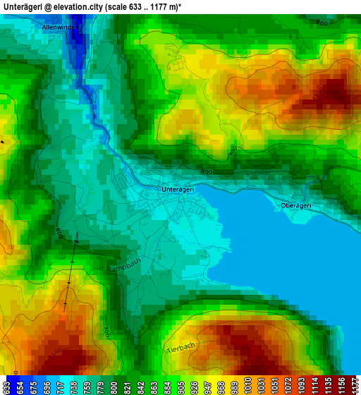
Below is the Elevation map of Unterägeri, which displays elevation range with different colors. Scale of the first map is from 633 to 1177 m (2077 to 3862 ft) with average elevation of 854.1 meters (=2802 ft) [note 1]
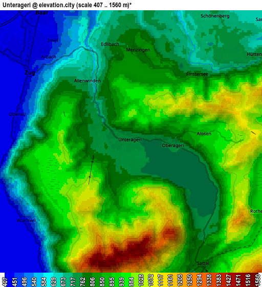
These maps also provides idea of topography and contour of this city, they are displayed at different zoom levels. More info about maps, scale and edge coordinates you can find below images.
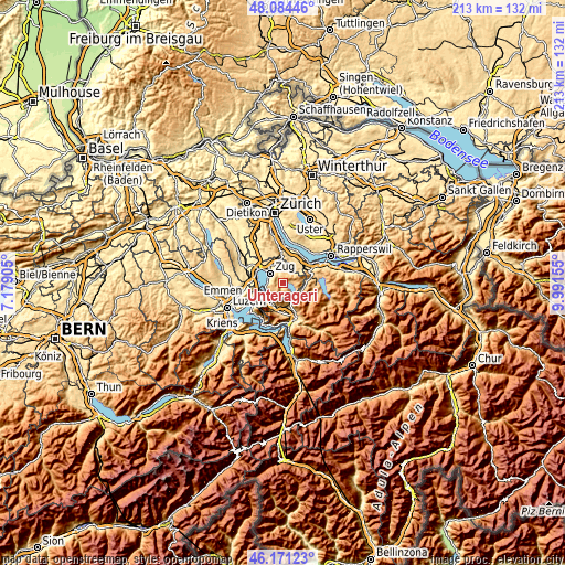
| \ | Map #1 | Map #2 | Topo.Map |
| Scale [m] | 633..1177 m | 407..1560 m | × |
| Scale [ft] | 2077..3862 ft | 1335..5118 ft | × |
| Average | 854.1 m = 2802 ft | 816.7 m = 2679 ft | × |
| Width | 6.65 km = 4.1 mi | 13.3 km = 8.3 mi | 212.7 km = 132.2 mi |
| Height | 6.65 km = 4.1 mi | 13.3 km = 8.3 mi | 212.7 km = 132.2 mi |
| ↑Max Latitude | 47.166336° | 47.196204° | 48.08446° |
| Latitude at center | 47.13645° | 47.13645° | 47.13645° |
| ↓Min Latitude | 47.106548° | 47.076628° | 46.17123° |
| ← Min Longitude | 8.541355° | 8.497409° | 7.17905° |
| Longitude center | 8.5853° | 8.5853° | 8.5853° |
| →Max Longitude | 8.629245° | 8.673191° | 9.99155° |
Nearby cities:
Cities around Unterägeri sort by population:
• Zug elevation 424 m
6.5 km,  307°
307°
• Baar 447 m
7.9 km,  327°
327°
• Cham 424 m
10.5 km,  298°
298°
• Arth 425 m
9.4 km,  209°
209°
• Steinhausen 425 m
10 km, 310°
• Goldau 517 m
10.3 km,  196°
196°
• Menzingen 806 m
4.6 km,  6°
6°
• Walchwil 479 m
6.5 km,  233°
233°
• Samstagern 628 m
9.5 km,  49°
49°
• Steinen 477 m
9.9 km,  168°
168°
• Rothenthurm 928 m
7.7 km,  117°
117°
• Sattel 811 m
7.1 km,  147°
147°
Multilingual:
 En español:
Unterägeri elevación 727 m.
 En France:
Unterägeri élévation 727 m.
 Auf Deutsch:
Unterägeri höhe über dem Meeresspiegel ist 727 m.

Sources and notes:
- [note 1] Map square and city borders are not equal. Map elevation data is calculated only from area inside that square.
- [src 1] Elevation data from geonames database provided with same terms of usage.
- [src 2] The elevation map of Unterägeri is generated using elevation data from NASA's 3 arcsec (90m) resolution SRTM data.
- [src 3] Base (background) map © OpenStreetMap contributors tiles are generated by Geofabrik and OpenTopoMap.
Copyright & License:
This Unterägeri Elevation Map is licensed under CC BY-SA. You may reuse any part from this page, if you give a proper credit by linking to this URL:
 More info on terms of use page.