Mbanza-Ngungu elevation
Mbanza-Ngungu (Bas-Congo), Democratic Republic of the Congo elevation is 735 meters and Mbanza-Ngungu elevation in feet is 2411 ft above sea level [src 1]. Mbanza-Ngungu is a populated place (feature code) with elevation that is 79 meters (259 ft) bigger than average city elevation in Democratic Republic of the Congo.
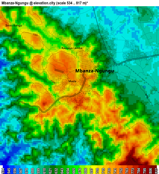
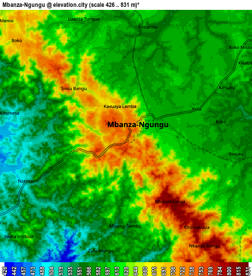
Below is the Elevation map of Mbanza-Ngungu, which displays elevation range with different colors. Scale of the first map is from 534 to 817 m (1752 to 2680 ft) with average elevation of 650.3 meters (=2134 ft) [note 1]
These maps also provides idea of topography and contour of this city, they are displayed at different zoom levels. More info about maps, scale and edge coordinates you can find below images.
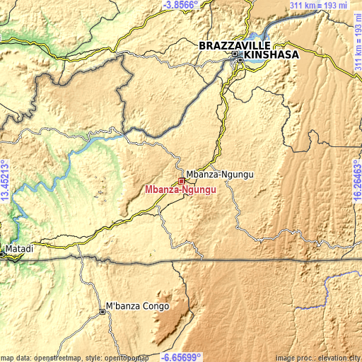
| \ | Map #1 | Map #2 | Topo.Map |
| Scale [m] | 534..817 m | 426..831 m | × |
| Scale [ft] | 1752..2680 ft | 1398..2726 ft | × |
| Average | 650.3 m = 2134 ft | 607.4 m = 1993 ft | × |
| Width | 9.73 km = 6 mi | 19.46 km = 12.1 mi | 311.4 km = 193.5 mi |
| Height | 9.73 km = 6 mi | 19.46 km = 12.1 mi | 311.4 km = 193.5 mi |
| ↑Max Latitude | -5.214608° | -5.170843° | -3.8566° |
| Latitude at center | -5.25837° | -5.25837° | -5.25837° |
| ↓Min Latitude | -5.302129° | -5.345885° | -6.65699° |
| ← Min Longitude | 14.814435° | 14.770489° | 13.45213° |
| Longitude center | 14.85838° | 14.85838° | 14.85838° |
| →Max Longitude | 14.902325° | 14.946271° | 16.26463° |
Nearby cities:
Cities around Mbanza-Ngungu sort by population:
• Kinshasa elevation 281 m
115.1 km,  25°
25°
• Masina 288 m
113.8 km, 31°
• Matadi 183 m
167.4 km,  247°
247°
• Boma 11 m
210.3 km, 251°
• Bandundu 322 m
353.3 km,  52°
52°
• Moanda 30 m
285.1 km, 254°
• Nioki 326 m
422.2 km, 48°
• Tshela 163 m
213.5 km,  277°
277°
• Mushie 325 m
338.3 km,  42°
42°
• Kasangulu 413 m
82.4 km,  24°
24°
• Bolobo 321 m
376.9 km, 23°
• Kasongo-Lunda 534 m
255.6 km,  122°
122°
Multilingual:
 En español:
Mbanza-Ngungu elevación 735 m.
 En France:
Mbanza-Ngungu élévation 735 m.
 Auf Deutsch:
Mbanza-Ngungu höhe über dem Meeresspiegel ist 735 m.

Sources and notes:
- [note 1] Map square and city borders are not equal. Map elevation data is calculated only from area inside that square.
- [src 1] Elevation data from geonames database provided with same terms of usage.
- [src 2] The elevation map of Mbanza-Ngungu is generated using elevation data from NASA's 3 arcsec (90m) resolution SRTM data.
- [src 3] Base (background) map © OpenStreetMap contributors tiles are generated by Geofabrik and OpenTopoMap.
Copyright & License:
This Mbanza-Ngungu Elevation Map is licensed under CC BY-SA. You may reuse any part from this page, if you give a proper credit by linking to this URL:
 More info on terms of use page.