Fundy Bay elevation
Fundy Bay (New Brunswick, Charlotte County), Canada elevation is 12 meters and Fundy Bay elevation in feet is 39 ft above sea level [src 1]. Fundy Bay is a populated place (feature code) with elevation that is 246 meters (807 ft) smaller than average city elevation in Canada.
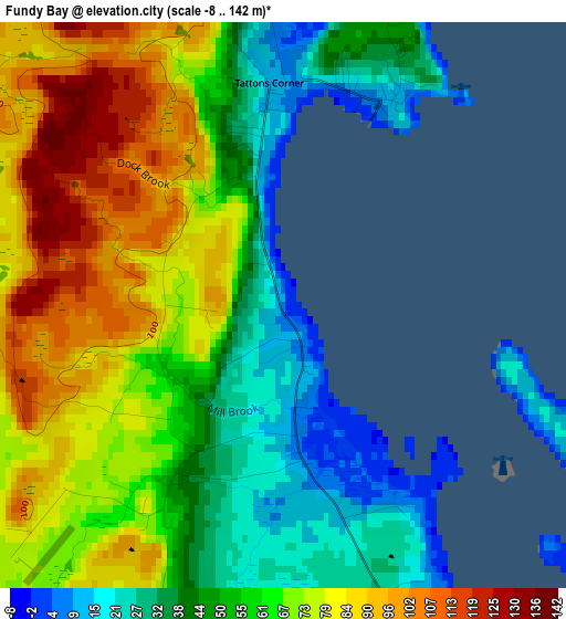
Below is the Elevation map of Fundy Bay, which displays elevation range with different colors. Scale of the first map is from -8 to 142 m (-26 to 466 ft) with average elevation of 61.6 meters (=202 ft) [note 1]
These maps also provides idea of topography and contour of this city, they are displayed at different zoom levels. More info about maps, scale and edge coordinates you can find below images.
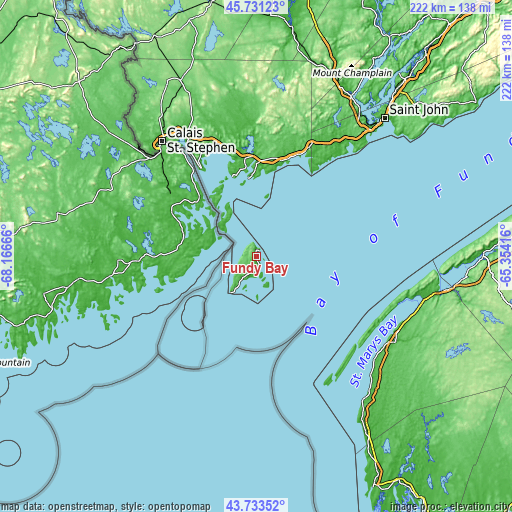
| \ | Map #1 | Topo.Map |
| Scale [m] | -8..142 m | × |
| Scale [ft] | -26..466 ft | × |
| Average | 61.6 m = 202 ft | × |
| Width | 6.94 km = 4.3 mi | 222.1 km = 138 mi |
| Height | 6.94 km = 4.3 mi | 222.1 km = 138 mi |
| ↑Max Latitude | 44.772206° | 45.73123° |
| Latitude at center | 44.741° | 44.741° |
| ↓Min Latitude | 44.709777° | 43.73352° |
| ← Min Longitude | -66.804355° | -68.16666° |
| Longitude center | -66.76041° | -66.76041° |
| →Max Longitude | -66.716465° | -65.35416° |
Nearby cities:
Cities around Fundy Bay sort by population:
• Saint John elevation 5 m
80.4 km,  42°
42°
• Fredericton 110 m
134.1 km,  3°
3°
• Oromocto 27 m
123.6 km,  10°
10°
• Yarmouth 26 m
113.2 km,  153°
153°
• Hampton 0 m
112.8 km, 39°
• Lincoln 7 m
129.6 km, 6°
• New Maryland 67 m
126.8 km, 3°
• Starlight Village 92 m
127 km,  359°
359°
• Digby 35 m
80.3 km,  99°
99°
• Saint Andrews 9 m
43.6 km,  328°
328°
• Middleton 20 m
135.1 km,  80°
80°
• Wells 64 m
97.8 km, 42°
Multilingual:
 En español:
Fundy Bay elevación 12 m.
 En France:
Fundy Bay élévation 12 m.
 Auf Deutsch:
Fundy Bay höhe über dem Meeresspiegel ist 12 m.

Sources and notes:
- [note 1] Map square and city borders are not equal. Map elevation data is calculated only from area inside that square.
- [src 1] Elevation data from geonames database provided with same terms of usage.
- [src 2] The elevation map of Fundy Bay is generated using elevation data from NASA's 3 arcsec (90m) resolution SRTM data.
- [src 3] Base (background) map © OpenStreetMap contributors tiles are generated by Geofabrik and OpenTopoMap.
Copyright & License:
This Fundy Bay Elevation Map is licensed under CC BY-SA. You may reuse any part from this page, if you give a proper credit by linking to this URL:
 More info on terms of use page.