Saint-Norbert elevation
Saint-Norbert (Quebec, Lanaudière), Canada elevation is 76 meters and Saint-Norbert elevation in feet is 249 ft above sea level [src 1]. Saint-Norbert is a populated place (feature code) with elevation that is 182 meters (597 ft) smaller than average city elevation in Canada.
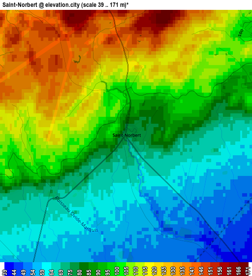
Below is the Elevation map of Saint-Norbert, which displays elevation range with different colors. Scale of the first map is from 39 to 171 m (128 to 561 ft) with average elevation of 92.5 meters (=303 ft) [note 1]
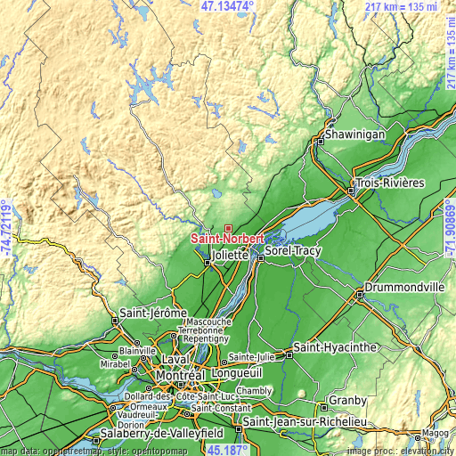
These maps also provides idea of topography and contour of this city, they are displayed at different zoom levels. More info about maps, scale and edge coordinates you can find below images.
| \ | Map #1 | Topo.Map |
| Scale [m] | 39..171 m | × |
| Scale [ft] | 128..561 ft | × |
| Average | 92.5 m = 303 ft | × |
| Width | 6.77 km = 4.2 mi | 216.6 km = 134.6 mi |
| Height | 6.77 km = 4.2 mi | 216.6 km = 134.6 mi |
| ↑Max Latitude | 46.199915° | 47.13474° |
| Latitude at center | 46.16949° | 46.16949° |
| ↓Min Latitude | 46.139048° | 45.187° |
| ← Min Longitude | -73.358885° | -74.72119° |
| Longitude center | -73.31494° | -73.31494° |
| →Max Longitude | -73.270995° | -71.90869° |
Nearby cities:
Cities around Saint-Norbert sort by population:
• Sorel-Tracy elevation 13 m
21 km,  132°
132°
• Joliette 57 m
19 km,  206°
206°
• Notre-Dame-des-Prairies 62 m
16.1 km, 214°
• Saint-Félix-de-Valois 123 m
8.5 km,  270°
270°
• Berthierville 9 m
14 km, 133°
• Saint-Thomas 28 m
17.2 km,  188°
188°
• Saint-Gabriel 190 m
15.4 km,  340°
340°
• Mandeville 188 m
22.1 km,  353°
353°
• Sainte-Béatrix 204 m
23.4 km,  278°
278°
• Saint-Ambroise 92 m
21.3 km,  240°
240°
• Sainte-Élisabeth 51 m
8.8 km,  198°
198°
• Maskinongé 14 m
23.7 km,  73°
73°
Multilingual:
 En español:
Saint-Norbert elevación 76 m.
 En France:
Saint-Norbert élévation 76 m.
 Auf Deutsch:
Saint-Norbert höhe über dem Meeresspiegel ist 76 m.

Sources and notes:
- [note 1] Map square and city borders are not equal. Map elevation data is calculated only from area inside that square.
- [src 1] Elevation data from geonames database provided with same terms of usage.
- [src 2] The elevation map of Saint-Norbert is generated using elevation data from NASA's 3 arcsec (90m) resolution SRTM data.
- [src 3] Base (background) map © OpenStreetMap contributors tiles are generated by Geofabrik and OpenTopoMap.
Copyright & License:
This Saint-Norbert Elevation Map is licensed under CC BY-SA. You may reuse any part from this page, if you give a proper credit by linking to this URL:
 More info on terms of use page.