Pont-Rouge elevation
Pont-Rouge (Quebec, Capitale-Nationale), Canada elevation is 104 meters and Pont-Rouge elevation in feet is 341 ft above sea level [src 1]. Pont-Rouge is a populated place (feature code) with elevation that is 154 meters (505 ft) smaller than average city elevation in Canada.
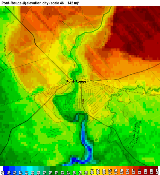
Below is the Elevation map of Pont-Rouge, which displays elevation range with different colors. Scale of the first map is from 46 to 142 m (151 to 466 ft) with average elevation of 103.4 meters (=339 ft) [note 1]
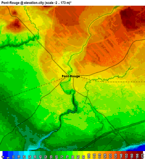
These maps also provides idea of topography and contour of this city, they are displayed at different zoom levels. More info about maps, scale and edge coordinates you can find below images.
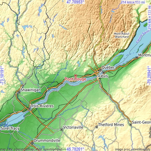
| \ | Map #1 | Map #2 | Topo.Map |
| Scale [m] | 46..142 m | -2..173 m | × |
| Scale [ft] | 151..466 ft | -7..568 ft | × |
| Average | 103.4 m = 339 ft | 97.2 m = 319 ft | × |
| Width | 6.7 km = 4.2 mi | 13.39 km = 8.3 mi | 214.3 km = 133.2 mi |
| Height | 6.7 km = 4.2 mi | 13.39 km = 8.3 mi | 214.2 km = 133.1 mi |
| ↑Max Latitude | 46.78478° | 46.814862° | 47.70953° |
| Latitude at center | 46.75468° | 46.75468° | 46.75468° |
| ↓Min Latitude | 46.724564° | 46.69443° | 45.78261° |
| ← Min Longitude | -71.739605° | -71.783551° | -73.10191° |
| Longitude center | -71.69566° | -71.69566° | -71.69566° |
| →Max Longitude | -71.651715° | -71.607769° | -70.28941° |
Nearby cities:
Cities around Pont-Rouge sort by population:
• La Haute-Saint-Charles elevation 151 m
28.9 km,  58°
58°
• Saint-Augustin-de-Desmaures 78 m
18.7 km,  94°
94°
• L'Ancienne-Lorette 27 m
26.5 km,  80°
80°
• Donnacona 60 m
8.5 km,  194°
194°
• Shannon 170 m
19.6 km,  44°
44°
• Sainte Catherine de la Jacques Cartier 159 m
12.3 km,  27°
27°
• Neuville 18 m
10.7 km,  126°
126°
• Portneuf 12 m
16.4 km,  244°
244°
• Cap-Santé 38 m
11.6 km,  217°
217°
• Saint-Marc-des-Carrières 47 m
28.1 km,  253°
253°
• Fossambault-sur-le-Lac 165 m
14.9 km,  24°
24°
• Saint-Antoine-de-Tilly 49 m
13.8 km,  137°
137°
Multilingual:
 En español:
Pont-Rouge elevación 104 m.
 En France:
Pont-Rouge élévation 104 m.
 Auf Deutsch:
Pont-Rouge höhe über dem Meeresspiegel ist 104 m.

Sources and notes:
- [note 1] Map square and city borders are not equal. Map elevation data is calculated only from area inside that square.
- [src 1] Elevation data from geonames database provided with same terms of usage.
- [src 2] The elevation map of Pont-Rouge is generated using elevation data from NASA's 3 arcsec (90m) resolution SRTM data.
- [src 3] Base (background) map © OpenStreetMap contributors tiles are generated by Geofabrik and OpenTopoMap.
Copyright & License:
This Pont-Rouge Elevation Map is licensed under CC BY-SA. You may reuse any part from this page, if you give a proper credit by linking to this URL:
 More info on terms of use page.