Metabetchouan-Lac-a-la-Croix elevation
Metabetchouan-Lac-a-la-Croix (Quebec, Saguenay/Lac-Saint-Jean), Canada elevation is 160 meters and Metabetchouan-Lac-a-la-Croix elevation in feet is 525 ft above sea level [src 1]. Metabetchouan-Lac-a-la-Croix is a populated place (feature code) with elevation that is 98 meters (322 ft) smaller than average city elevation in Canada.
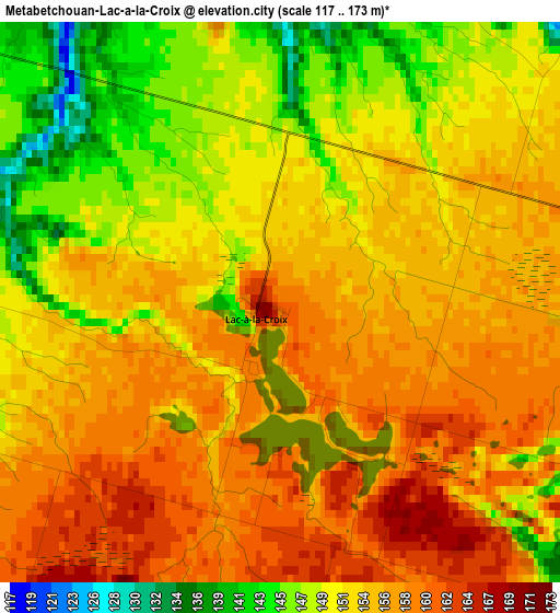
Below is the Elevation map of Metabetchouan-Lac-a-la-Croix, which displays elevation range with different colors. Scale of the first map is from 117 to 173 m (384 to 568 ft) with average elevation of 153.4 meters (=503 ft) [note 1]
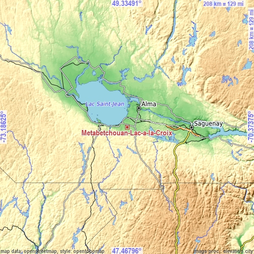
These maps also provides idea of topography and contour of this city, they are displayed at different zoom levels. More info about maps, scale and edge coordinates you can find below images.
| \ | Map #1 | Map #2 | Topo.Map |
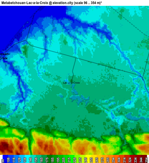
| Scale [m] | 117..173 m | 96..354 m | × |
| Scale [ft] | 384..568 ft | 315..1161 ft | × |
| Average | 153.4 m = 503 ft | 159.6 m = 524 ft | × |
| Width | 6.49 km = 4 mi | 12.97 km = 8.1 mi | 207.6 km = 129 mi |
| Height | 6.49 km = 4 mi | 12.97 km = 8.1 mi | 207.6 km = 129 mi |
| ↑Max Latitude | 48.439162° | 48.468308° | 49.33491° |
| Latitude at center | 48.41° | 48.41° | 48.41° |
| ↓Min Latitude | 48.380821° | 48.351625° | 47.46796° |
| ← Min Longitude | -71.823945° | -71.867891° | -73.18625° |
| Longitude center | -71.78° | -71.78° | -71.78° |
| →Max Longitude | -71.736055° | -71.692109° | -70.37375° |
Nearby cities:
Cities around Metabetchouan-Lac-a-la-Croix sort by population:
• Jonquière elevation 142 m
39.2 km,  88°
88°
• Alma 90 m
18.3 km,  31°
31°
• Roberval 113 m
35.4 km,  289°
289°
• Pointe-du-Lac 101 m
10 km,  358°
358°
• Saint-Bruno 150 m
11.5 km,  56°
56°
• Métabetchouan 237 m
18.1 km,  254°
254°
• Saint-Gédéon 112 m
10.1 km,  5°
5°
• Chambord 141 m
21.3 km,  277°
277°
• Saint-Ambroise 125 m
36.5 km, 64°
• L'Ascension-de-Notre-Seigneur 139 m
31.5 km,  15°
15°
• Saint-Prime 115 m
45 km,  295°
295°
• Saint-Nazaire 148 m
26.1 km,  40°
40°
Multilingual:
 En español:
Metabetchouan-Lac-a-la-Croix elevación 160 m.
 En France:
Métabetchouan–Lac-à-la-Croix élévation 160 m.
 Auf Deutsch:
Metabetchouan-Lac-a-la-Croix höhe über dem Meeresspiegel ist 160 m.
 На русском:
Metabetchouan-Lac-a-la-Croix высота над уровнем моря 160 м
Sources and notes:
- [note 1] Map square and city borders are not equal. Map elevation data is calculated only from area inside that square.
- [src 1] Elevation data from geonames database provided with same terms of usage.
- [src 2] The elevation map of Metabetchouan-Lac-a-la-Croix is generated using elevation data from NASA's 3 arcsec (90m) resolution SRTM data.
- [src 3] Base (background) map © OpenStreetMap contributors tiles are generated by Geofabrik and OpenTopoMap.
Copyright & License:
This Metabetchouan-Lac-a-la-Croix Elevation Map is licensed under CC BY-SA. You may reuse any part from this page, if you give a proper credit by linking to this URL:
 More info on terms of use page.