Thunder Bay elevation
Thunder Bay (Ontario, Thunder Bay District), Canada elevation is 188 meters and Thunder Bay elevation in feet is 617 ft above sea level [src 1]. Thunder Bay is a populated place (feature code) with elevation that is 70 meters (230 ft) smaller than average city elevation in Canada.
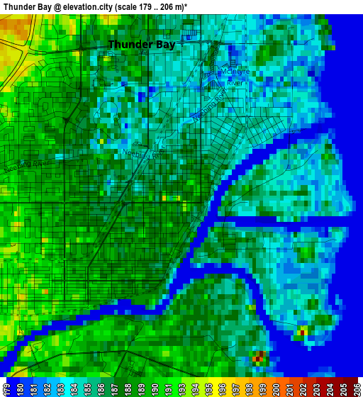
Below is the Elevation map of Thunder Bay, which displays elevation range with different colors. Scale of the first map is from 179 to 206 m (587 to 676 ft) with average elevation of 186.4 meters (=612 ft) [note 1]
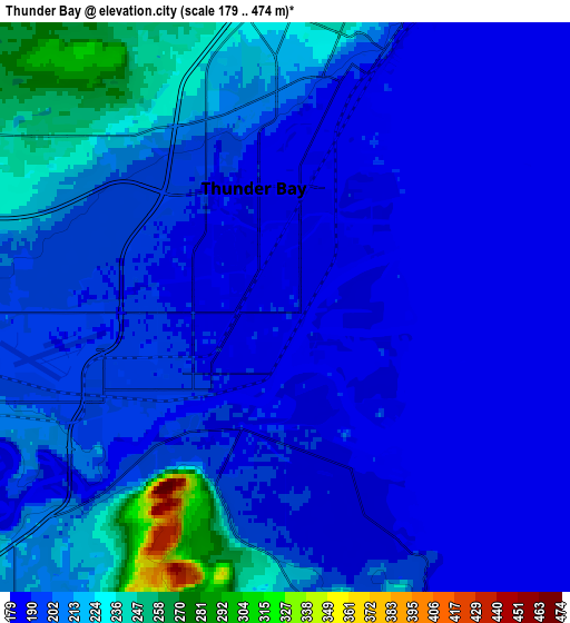
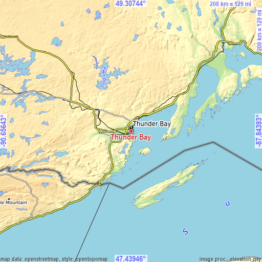
These maps also provides idea of topography and contour of this city, they are displayed at different zoom levels. More info about maps, scale and edge coordinates you can find below images.
| \ | Map #1 | Map #2 | Topo.Map |
| Scale [m] | 179..206 m | 179..474 m | × |
| Scale [ft] | 587..676 ft | 587..1555 ft | × |
| Average | 186.4 m = 612 ft | 200.4 m = 657 ft | × |
| Width | 6.49 km = 4 mi | 12.98 km = 8.1 mi | 207.7 km = 129.1 mi |
| Height | 6.49 km = 4 mi | 12.98 km = 8.1 mi | 207.7 km = 129.1 mi |
| ↑Max Latitude | 48.411198° | 48.44036° | 49.30744° |
| Latitude at center | 48.38202° | 48.38202° | 48.38202° |
| ↓Min Latitude | 48.352825° | 48.323613° | 47.43946° |
| ← Min Longitude | -89.294125° | -89.338071° | -90.65643° |
| Longitude center | -89.25018° | -89.25018° | -89.25018° |
| →Max Longitude | -89.206235° | -89.162289° | -87.84393° |
Nearby cities:
Cities around Thunder Bay sort by population:
• Dryden elevation 387 m
298.7 km,  301°
301°
• Greenstone 339 m
213.6 km,  45°
45°
• Atikokan 390 m
179.6 km,  283°
283°
• Marathon 179 m
211.3 km,  78°
78°
• Sioux Lookout 412 m
272.9 km,  313°
313°
• Neebing 234 m
26.9 km,  207°
207°
• Manitouwadge 331 m
263.1 km,  71°
71°
• Lappe 416 m
21.8 km,  340°
340°
Multilingual:
 En español:
Thunder Bay elevación 188 m.
 En France:
Thunder Bay élévation 188 m.
 Auf Deutsch:
Thunder Bay höhe über dem Meeresspiegel ist 188 m.

Sources and notes:
- [note 1] Map square and city borders are not equal. Map elevation data is calculated only from area inside that square.
- [src 1] Elevation data from geonames database provided with same terms of usage.
- [src 2] The elevation map of Thunder Bay is generated using elevation data from NASA's 3 arcsec (90m) resolution SRTM data.
- [src 3] Base (background) map © OpenStreetMap contributors tiles are generated by Geofabrik and OpenTopoMap.
Copyright & License:
This Thunder Bay Elevation Map is licensed under CC BY-SA. You may reuse any part from this page, if you give a proper credit by linking to this URL:
 More info on terms of use page.