Saint-Sauveur-des-Monts elevation
Saint-Sauveur-des-Monts (Quebec, Laurentides), Canada elevation is 216 meters and Saint-Sauveur-des-Monts elevation in feet is 709 ft above sea level [src 1]. Saint-Sauveur-des-Monts is a populated place (feature code) with elevation that is 42 meters (138 ft) smaller than average city elevation in Canada.
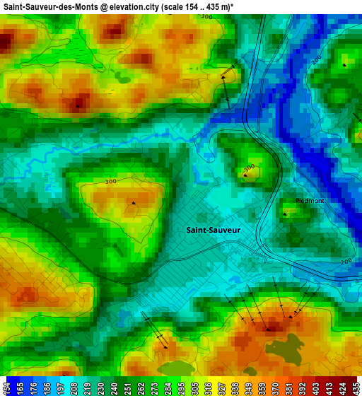
Below is the Elevation map of Saint-Sauveur-des-Monts, which displays elevation range with different colors. Scale of the first map is from 154 to 435 m (505 to 1427 ft) with average elevation of 265.5 meters (=871 ft) [note 1]
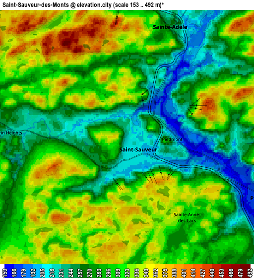
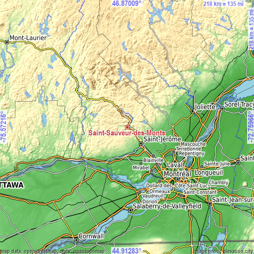
These maps also provides idea of topography and contour of this city, they are displayed at different zoom levels. More info about maps, scale and edge coordinates you can find below images.
| \ | Map #1 | Map #2 | Topo.Map |
| Scale [m] | 154..435 m | 153..492 m | × |
| Scale [ft] | 505..1427 ft | 502..1614 ft | × |
| Average | 265.5 m = 871 ft | 298.2 m = 978 ft | × |
| Width | 6.8 km = 4.2 mi | 13.6 km = 8.5 mi | 217.6 km = 135.2 mi |
| Height | 6.8 km = 4.2 mi | 13.6 km = 8.5 mi | 217.6 km = 135.2 mi |
| ↑Max Latitude | 45.930654° | 45.96121° | 46.87009° |
| Latitude at center | 45.90008° | 45.90008° | 45.90008° |
| ↓Min Latitude | 45.86949° | 45.838882° | 44.91283° |
| ← Min Longitude | -74.209855° | -74.253801° | -75.57216° |
| Longitude center | -74.16591° | -74.16591° | -74.16591° |
| →Max Longitude | -74.121965° | -74.078019° | -72.75966° |
Nearby cities:
Cities around Saint-Sauveur-des-Monts sort by population:
• Saint-Jérôme elevation 95 m
18.3 km,  136°
136°
• Sainte-Adèle 246 m
6.1 km,  24°
24°
• Prévost 166 m
7.4 km,  119°
119°
• Saint-Sauveur 254 m
1.8 km,  215°
215°
• Saint-Hippolyte 254 m
12.2 km,  72°
72°
• Terrasse-des-Pins 178 m
8.7 km, 117°
• Morin-Heights 240 m
6.4 km,  270°
270°
• Saint-Adolphe-d'Howard 374 m
14.9 km,  299°
299°
• Val-Morin 335 m
11.2 km,  353°
353°
• Piedmont 184 m
2.6 km,  90°
90°
• Lac-Connelly 216 m
15 km, 90°
• Val-David 325 m
15.3 km, 345°
Multilingual:
 En español:
Saint-Sauveur-des-Monts elevación 216 m.
 En France:
Saint-Sauveur-des-Monts élévation 216 m.
 Auf Deutsch:
Saint-Sauveur-des-Monts höhe über dem Meeresspiegel ist 216 m.
 На русском:
Saint-Sauveur-des-Monts высота над уровнем моря 216 м
Sources and notes:
- [note 1] Map square and city borders are not equal. Map elevation data is calculated only from area inside that square.
- [src 1] Elevation data from geonames database provided with same terms of usage.
- [src 2] The elevation map of Saint-Sauveur-des-Monts is generated using elevation data from NASA's 3 arcsec (90m) resolution SRTM data.
- [src 3] Base (background) map © OpenStreetMap contributors tiles are generated by Geofabrik and OpenTopoMap.
Copyright & License:
This Saint-Sauveur-des-Monts Elevation Map is licensed under CC BY-SA. You may reuse any part from this page, if you give a proper credit by linking to this URL:
 More info on terms of use page.