Sainte-Catherine elevation
Sainte-Catherine (Quebec, Montérégie), Canada elevation is 25 meters and Sainte-Catherine elevation in feet is 82 ft above sea level [src 1]. Sainte-Catherine is a populated place (feature code) with elevation that is 233 meters (764 ft) smaller than average city elevation in Canada.
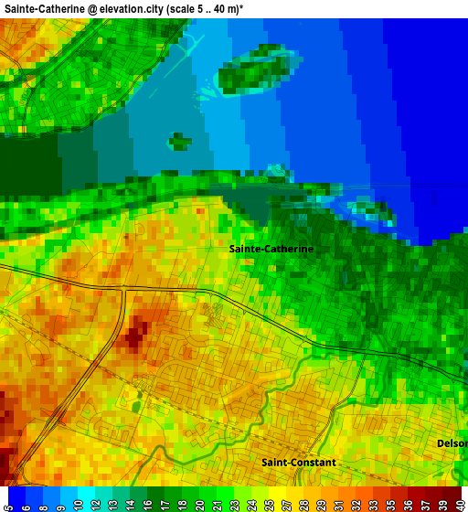
Below is the Elevation map of Sainte-Catherine, which displays elevation range with different colors. Scale of the first map is from 5 to 40 m (16 to 131 ft) with average elevation of 19.9 meters (=65 ft) [note 1]
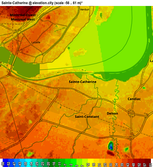
These maps also provides idea of topography and contour of this city, they are displayed at different zoom levels. More info about maps, scale and edge coordinates you can find below images.
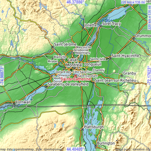
| \ | Map #1 | Map #2 | Topo.Map |
| Scale [m] | 5..40 m | -56..61 m | × |
| Scale [ft] | 16..131 ft | -184..200 ft | × |
| Average | 19.9 m = 65 ft | 23 m = 75 ft | × |
| Width | 6.86 km = 4.3 mi | 13.72 km = 8.5 mi | 219.6 km = 136.5 mi |
| Height | 6.86 km = 4.3 mi | 13.72 km = 8.5 mi | 219.6 km = 136.5 mi |
| ↑Max Latitude | 45.430928° | 45.461759° | 46.37886° |
| Latitude at center | 45.40008° | 45.40008° | 45.40008° |
| ↓Min Latitude | 45.369215° | 45.338334° | 44.40405° |
| ← Min Longitude | -73.626425° | -73.670371° | -74.98873° |
| Longitude center | -73.58248° | -73.58248° | -73.58248° |
| →Max Longitude | -73.538535° | -73.494589° | -72.17623° |
Nearby cities:
Cities around Sainte-Catherine sort by population:
• Brossard elevation 17 m
10.7 km,  58°
58°
• Notre-Dame-de-Grâce 84 m
8.9 km,  343°
343°
• Côte-Saint-Luc 47 m
9.7 km,  318°
318°
• Saint-Constant 26 m
3.9 km,  160°
160°
• La Prairie 8 m
6.8 km,  74°
74°
• Westmount 52 m
9.4 km,  351°
351°
• Candiac 25 m
5.5 km,  109°
109°
• Delson 27 m
4.5 km,  144°
144°
• Montréal-Ouest 48 m
7.8 km, 318°
• Saint-Raymond 50 m
7.7 km, 344°
• Saint-Mathieu 36 m
10.6 km,  150°
150°
• Saint-Philippe-de-La Prairie 33 m
9.5 km,  120°
120°
Multilingual:
 En español:
Sainte-Catherine elevación 25 m.
 En France:
Sainte-Catherine élévation 25 m.
 Auf Deutsch:
Sainte-Catherine höhe über dem Meeresspiegel ist 25 m.

Sources and notes:
- [note 1] Map square and city borders are not equal. Map elevation data is calculated only from area inside that square.
- [src 1] Elevation data from geonames database provided with same terms of usage.
- [src 2] The elevation map of Sainte-Catherine is generated using elevation data from NASA's 3 arcsec (90m) resolution SRTM data.
- [src 3] Base (background) map © OpenStreetMap contributors tiles are generated by Geofabrik and OpenTopoMap.
Copyright & License:
This Sainte-Catherine Elevation Map is licensed under CC BY-SA. You may reuse any part from this page, if you give a proper credit by linking to this URL:
 More info on terms of use page.