Saint-Canut elevation
Saint-Canut (Quebec, Laurentides), Canada elevation is 68 meters and Saint-Canut elevation in feet is 223 ft above sea level [src 1]. Saint-Canut is a populated place (feature code) with elevation that is 190 meters (623 ft) smaller than average city elevation in Canada.
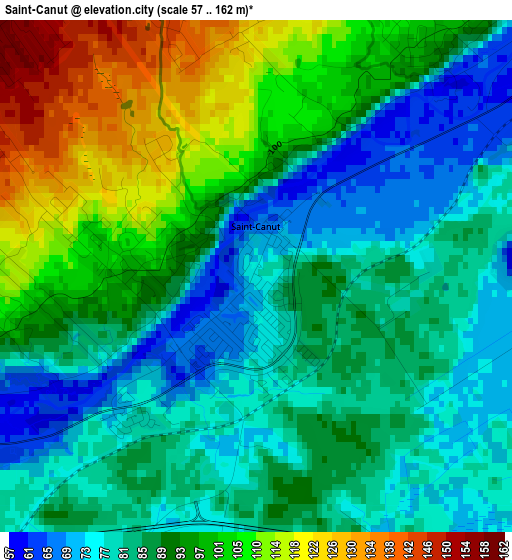
Below is the Elevation map of Saint-Canut, which displays elevation range with different colors. Scale of the first map is from 57 to 162 m (187 to 531 ft) with average elevation of 90.4 meters (=297 ft) [note 1]
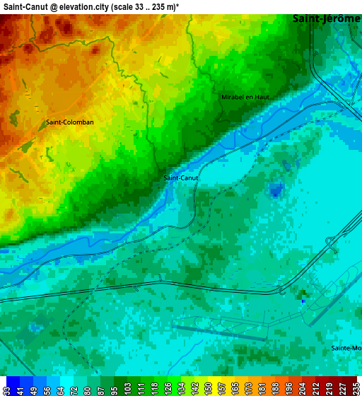
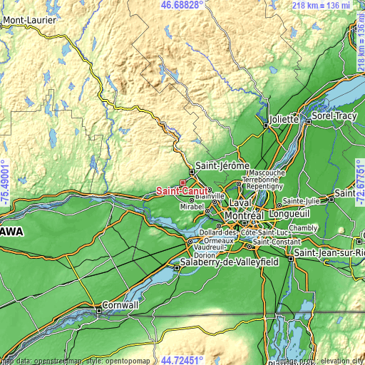
These maps also provides idea of topography and contour of this city, they are displayed at different zoom levels. More info about maps, scale and edge coordinates you can find below images.
| \ | Map #1 | Map #2 | Topo.Map |
| Scale [m] | 57..162 m | 33..235 m | × |
| Scale [ft] | 187..531 ft | 108..771 ft | × |
| Average | 90.4 m = 297 ft | 102.1 m = 335 ft | × |
| Width | 6.82 km = 4.2 mi | 13.65 km = 8.5 mi | 218.4 km = 135.7 mi |
| Height | 6.82 km = 4.2 mi | 13.65 km = 8.5 mi | 218.3 km = 135.6 mi |
| ↑Max Latitude | 45.745695° | 45.776354° | 46.68828° |
| Latitude at center | 45.71502° | 45.71502° | 45.71502° |
| ↓Min Latitude | 45.684328° | 45.653619° | 44.72451° |
| ← Min Longitude | -74.127705° | -74.171651° | -75.49001° |
| Longitude center | -74.08376° | -74.08376° | -74.08376° |
| →Max Longitude | -74.039815° | -73.995869° | -72.67751° |
Nearby cities:
Cities around Saint-Canut sort by population:
• Saint-Jérôme elevation 95 m
9.6 km,  40°
40°
• Blainville 73 m
16.5 km,  108°
108°
• Mirabel 70 m
7.2 km,  179°
179°
• Prévost 166 m
16.9 km,  0°
0°
• Lachute 70 m
20.6 km,  249°
249°
• Saint-Sauveur 254 m
20.5 km,  338°
338°
• Saint-Joseph-du-Lac 63 m
21.2 km,  161°
161°
• Lac-Alouette 99 m
14.9 km, 40°
• Terrasse-des-Pins 178 m
16.7 km, 4°
• Piedmont 184 m
20.9 km,  349°
349°
• Sainte-Sophie 73 m
18.2 km,  51°
51°
• Saint-Colomban 149 m
4.3 km,  298°
298°
Multilingual:
 En español:
Saint-Canut elevación 68 m.
 En France:
Saint-Canut élévation 68 m.
 Auf Deutsch:
Saint-Canut höhe über dem Meeresspiegel ist 68 m.

Sources and notes:
- [note 1] Map square and city borders are not equal. Map elevation data is calculated only from area inside that square.
- [src 1] Elevation data from geonames database provided with same terms of usage.
- [src 2] The elevation map of Saint-Canut is generated using elevation data from NASA's 3 arcsec (90m) resolution SRTM data.
- [src 3] Base (background) map © OpenStreetMap contributors tiles are generated by Geofabrik and OpenTopoMap.
Copyright & License:
This Saint-Canut Elevation Map is licensed under CC BY-SA. You may reuse any part from this page, if you give a proper credit by linking to this URL:
 More info on terms of use page.