Rivière-Rouge elevation
Rivière-Rouge (Quebec, Laurentides), Canada elevation is 240 meters and Rivière-Rouge elevation in feet is 787 ft above sea level [src 1]. Rivière-Rouge is a populated place (feature code) with elevation that is 18 meters (59 ft) smaller than average city elevation in Canada.
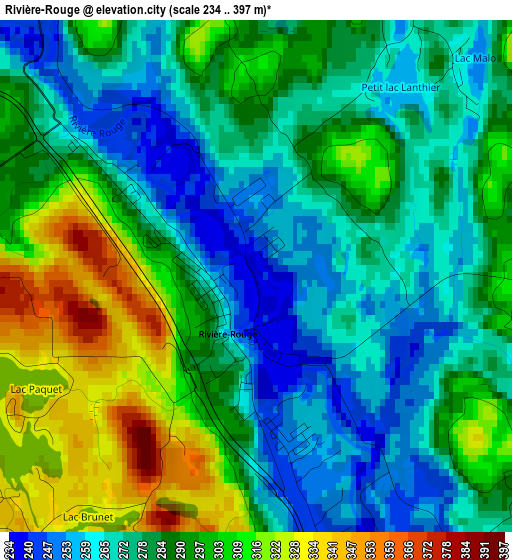
Below is the Elevation map of Rivière-Rouge, which displays elevation range with different colors. Scale of the first map is from 234 to 397 m (768 to 1302 ft) with average elevation of 286 meters (=938 ft) [note 1]
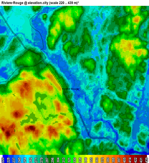
These maps also provides idea of topography and contour of this city, they are displayed at different zoom levels. More info about maps, scale and edge coordinates you can find below images.
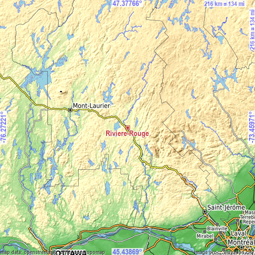
| \ | Map #1 | Map #2 | Topo.Map |
| Scale [m] | 234..397 m | 220..439 m | × |
| Scale [ft] | 768..1302 ft | 722..1440 ft | × |
| Average | 286 m = 938 ft | 295.5 m = 969 ft | × |
| Width | 6.74 km = 4.2 mi | 13.47 km = 8.4 mi | 215.6 km = 134 mi |
| Height | 6.74 km = 4.2 mi | 13.47 km = 8.4 mi | 215.6 km = 134 mi |
| ↑Max Latitude | 46.447078° | 46.477349° | 47.37766° |
| Latitude at center | 46.41679° | 46.41679° | 46.41679° |
| ↓Min Latitude | 46.386485° | 46.356164° | 45.43869° |
| ← Min Longitude | -74.909905° | -74.953851° | -76.27221° |
| Longitude center | -74.86596° | -74.86596° | -74.86596° |
| →Max Longitude | -74.822015° | -74.778069° | -73.45971° |
Nearby cities:
Cities around Rivière-Rouge sort by population:
• Mont-Laurier elevation 226 m
50.7 km,  286°
286°
• Mont-Tremblant 257 m
31.3 km,  136°
136°
• Sainte-Agathe-des-Monts 375 m
60.6 km,  132°
132°
• Saint-Adolphe-d'Howard 374 m
64.7 km, 140°
• Ferme-Neuve 219 m
54.6 km,  305°
305°
• La Conception 202 m
32.3 km,  156°
156°
• Lac-Simon 245 m
30.4 km, 161°
• Labelle 223 m
18 km,  145°
145°
• La Minerve 280 m
19.2 km,  195°
195°
• Saint-Donat-de-Montcalm 401 m
50.6 km,  102°
102°
• Val-David 325 m
65.7 km, 130°
• Notre-Dame-du-Mont-Carmel 235 m
47.5 km, 200°
Multilingual:
 En español:
Rivière-Rouge elevación 240 m.
 En France:
Rivière-Rouge élévation 240 m.
 Auf Deutsch:
Rivière-Rouge höhe über dem Meeresspiegel ist 240 m.

Sources and notes:
- [note 1] Map square and city borders are not equal. Map elevation data is calculated only from area inside that square.
- [src 1] Elevation data from geonames database provided with same terms of usage.
- [src 2] The elevation map of Rivière-Rouge is generated using elevation data from NASA's 3 arcsec (90m) resolution SRTM data.
- [src 3] Base (background) map © OpenStreetMap contributors tiles are generated by Geofabrik and OpenTopoMap.
Copyright & License:
This Rivière-Rouge Elevation Map is licensed under CC BY-SA. You may reuse any part from this page, if you give a proper credit by linking to this URL:
 More info on terms of use page.